Section 7: US Route 6 to NY Route 32 (Town of Woodbury)
Quick Facts
Distance: 11.35 miles (10.75 miles using seasonal Long Path route)
Parks: Harriman State Park, West Point
Maps: Interactive Map, Harriman-Bear Mountain Trails (map 119), West Hudson Trails (map 114)
Print-Friendly Version: Link
General Description
This section is the last of the three within Harriman State Park, and is by far the most rugged. The Long Path climbs four peaks, often on steep grades both up and down. The exertion is worth the effort because of views of dramatic geology, especially in the U-shaped valley between Howell and Brooks Mountains. The trail frequently borders West Point Military Reservation. The last part of this section is outside of Harriman State Park and generally follows suburban and rural roads, but a seasonal Long Path route has been established through West Point Military Reservation as footpath option during certain parts of the year.
Access
Take the New York State Thruway to Exit 16, Harriman. Continue east on US Route 6. Or take the Palisades Interstate Parkway to Exit 18, and continue west on Route 6. The section starts at a parking area in a narrow, unmarked loop on the north side of Route 6. Entry by car is one way from the east side of the loop, about 1.2 miles west of the Long Mountain Circle.
Parking
0.00 Parking area off Route 6. (41.315976°, -74.050148°)
3.85 There is parking along NY Route 293 near Barnes Lake (0.2 mi north of US Route 6), about 0.25 mi south of where the Long Path crosses the road. (41.326418°, -74.082527°)
6.45 Near the end of Estrada Road (pay attention to the 'No Parking' signs and do not block the gate). (41.320196°, -74.106322°)
11.60 Intersection of Evans Drive and NY Route 32, about 0.2 miles south of the Long Path's crossing of Route 32. (41.360910°, -74.107742°)
Trail Description
0.00 The Long Path leaves the pavement of the parking area loop road at the interpretive kiosk honoring Raymond H. Torrey and the Long Path. It heads north into the woods on a wide gravel road. The road becomes grassy as it passes through oak forest with open, short and shrubby understory. The descent into a hollow steepens as traffic noises fade.
0.30 Pass an old woods road going down to the left. Immediately thereafter, the Popolopen Gorge Trail (red square on white) leaves to the right. The Long Path turns left after this and begins to climb toward the summit of Long Mountain.
0.75 The Long Path reaches the summit of Long Mountain, the site of the Torrey Memorial. There is a spectacular 360-degree view from the summit with Bear Mountain visible to the east and Turkey Hill Lake directly below.
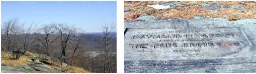
View from Long Mountain and Torrey Memorial. 2001 [TODD SCHREIBMAN]
0.80 The Long Path continues past the Torrey Memorial and starts a gradual descent from Long Mountain. In another 500 feet, the trail turns left and descends through a series of long switchbacks.
1.25 The trail intersects an old woods road to the left and crosses Deep Hollow Brook (the crossing can be difficult after a heavy rain). It then turns right and continues on a path alongside the stream. Meet a second stream paralleling the trail on the left. Shortly thereafter, the trail turns left at an opening in the woods and crosses the stream on rocks. It then ascends and approaches a cleared swath along the West Point boundary. The trail follows the boundary line, with some detours to the left and back again, for about half a mile. The trail eventually leaves the boundary permanently and heads left to top out at a knoll with lots of blueberries.
2.30 Reach the summit of Howell Mountain. The trail briefly continues its gentle descent on a curve, slabbing a rise to the right. Then, it abruptly turns left and begins a steep plunge into Brooks Hollow. The Long Path traverses a flat terrace before another left turn over the edge completes the descent, this time with switchbacks.
2.70 Cross the outlet stream from Lake Massawippa in the middle of Brooks Hollow, a classic U-shaped post-glacial valley. Its broad, flat floor with several intermittent streambeds, curves upward on both sides at a rapidly increasing pitch. Once across the stream, the trail turns left and goes upstream for a short distance before continuing across the valley floor. It reaches the valley wall and the trail begins a steep ascent of Brooks Mountain, principally by two long switchbacks. The second switchback becomes gentler in grade as it merges with the southwest trending crest of Brooks Mountain. Once on the crest, the grade is gently uphill with views of the steeply plunging valley to the left.
3.35 The ridge ends suddenly at a rocky knob. The Long Path turns to descend steeply to the left at first and then curves to the right around the end of the ridge. It reaches and climbs out of the small valley to views of Lake Massawippa a few hundred feet downhill to the left. The trail next undulates up and down through laurel and then blueberry, the dominant understory plants.
3.85 Reach NY Route 293 near a stream. Cross the road at the end of the guardrail, re-enter the woods, and start ascending.
4.05 The trail crosses a power line. The trail now ascends, often steeply, up the shoulder of Blackcap Mountain. Once attained, it follows the ridge crest southwest, closely paralleling the West Point boundary, until the trail descends toward Route 6.
4.55 Reach the southern trailhead of the seasonal Long Path. The seasonal Long Path on West Point property is closed May 1 through August 15 and during fall hunting season, and it is marked with aqua/white blazes. Please stay on the marked trail to avoid active military training exercises. If following the seasonal route, see turn-by-turn details at the end of this section description.
4.75 The trail crosses another power line, a small stream, and a stand of mountain laurel.
5.30 The trail approaches US Route 6 and turns west along the highway. The next blazes are about 30 feet inside the woods bordering the road, next to a chain-link fence.
5.60 Just before a small stream the trail turns left, leaves the woods, and turns right to cross a road (OP Charlie Road) near a West Point entrance gate. Continue through the wide grassy berme along Route 6. The trail veers to the right and crosses a clearing on a diagonal to the northwest. At the opposite side of the clearing, there is a telephone pole at the end of an abandoned paved road (the old Route 6).
5.85 Continue along the abandoned paved road.
6.45 Reach a barricade across the road with a small vehicle turnaround just beyond, on the right. The trail continues straight ahead on what is now known as Estrada Road, a quiet residential street, past several houses. Thomas Estrada-Palma, the first president of Cuba (1902-06), lived here from 1879 to 1902 while he headed a junta that financed the Cuban Revolution.
7.40 Continue straight, staying on Estrada Road. In 200 feet, in sight of the New York State Thruway, turn right onto Abrams Road. Pass Stone Gate Road on the right.
8.20 At a T-intersection, go right on Smith Clove Road (Orange County Route 9) and head away from the Thruway.
8.70 Pass a golf course entrance on right.
8.80 Turn left on Pine Hill Road. On the south side of Smith Clove Road opposite Pine Hill Road is the northern trailhead of the seasonal Long Path. Look for the aqua/white blazes between the golf course parking lot and The Gatehouse historic building.
9.40 Cross the Thruway and follow Pine Hill Road downhill as it curves.
9.70 Follow Pine Hill Road under the railroad.
9.80 Just before Pine Hill Road crosses Woodbury Creek, the Long Path turns right on a gravel road and gas-pipeline right-of-way, which runs between the railroad tracks and Woodbury Creek.
10.70 Cross a seasonal stream.
11.30 Pass underneath a railroad trestle (formerly the Graham Line of the Erie Railroad, now the Metro-North Port Jervis Line), go down the embankment, and cross Woodbury Creek. Note there is no formal crossing here and the water can be deep and fast, so prepare accordingly. After crossing the creek, turn right and climb to Route 32, which it crosses (use caution, as Route 32 is a very busy highway).
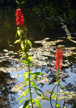
Cardinal flowers along the Woodbury Creek. 2010 [JAKOB FRANKE]
11.35 Section 7 ends about 100 ft north of the trestle, where the Long Path reaches a driveway and immediately turns left to climb an embankment. Note that the Highlands Trail (teal diamond blazes) joins the Long Path here after following Route 32 from the north, coaligning with the Long Path into Section 8.
Seasonal Long Path
4.55 Reach the southern trailhead of the seasonal Long Path. The seasonal Long Path on West Point property is closed May 1 through August 15 and during fall hunting season, and it is marked with aqua/white blazes. Please stay on the marked trail to avoid active military training exercises. If the seasonal route is closed, see turn-by-turn details above.
5.40 Cross OP Charlie Road.
6.75 Cross Proctoria Road, and descend on a series of switchbacks.
7.10 Cross Proctoria Road a second time.
7.60 Cross the outlet stream of Frederick Lake.
8.20 Reach the northern trailhead of the seasonal Long Path between a golf course parking lot and The Gatehouse historic building. Continue straight onto Pine Hill Road.
8.80 Cross the Thruway and follow Pine Hill Road downhill as it curves.
9.10 Follow Pine Hill Road under the railroad.
9.20 Just before Pine Hill Road crosses Woodbury Creek, the Long Path turns right on a gravel road and gas-pipeline right-of-way, which runs between the railroad tracks and Woodbury Creek.
10.10 Cross a seasonal stream.
10.70 Pass underneath a railroad trestle (formerly the Graham Line of the Erie Railroad, now the Metro-North Port Jervis Line), go down the embankment, and cross Woodbury Creek. Note there is no formal crossing here and the water can be deep and fast, so prepare accordingly. After crossing the creek, turn right and climb to Route 32, which it crosses (use caution, as Route 32 is a very busy highway).
10.75 Section 7 ends about 100 ft north of the trestle, where the Long Path reaches a driveway and immediately turns left to climb an embankment.
Comment: Please be relevant, civil, non-commercial.
The journey of....
LP seasonal route?
LP Seasonal Route
GM's Day 7 of Long Path