Ruin

Overlook Mountain

NYNJTC maintained: 
1
Summary: 

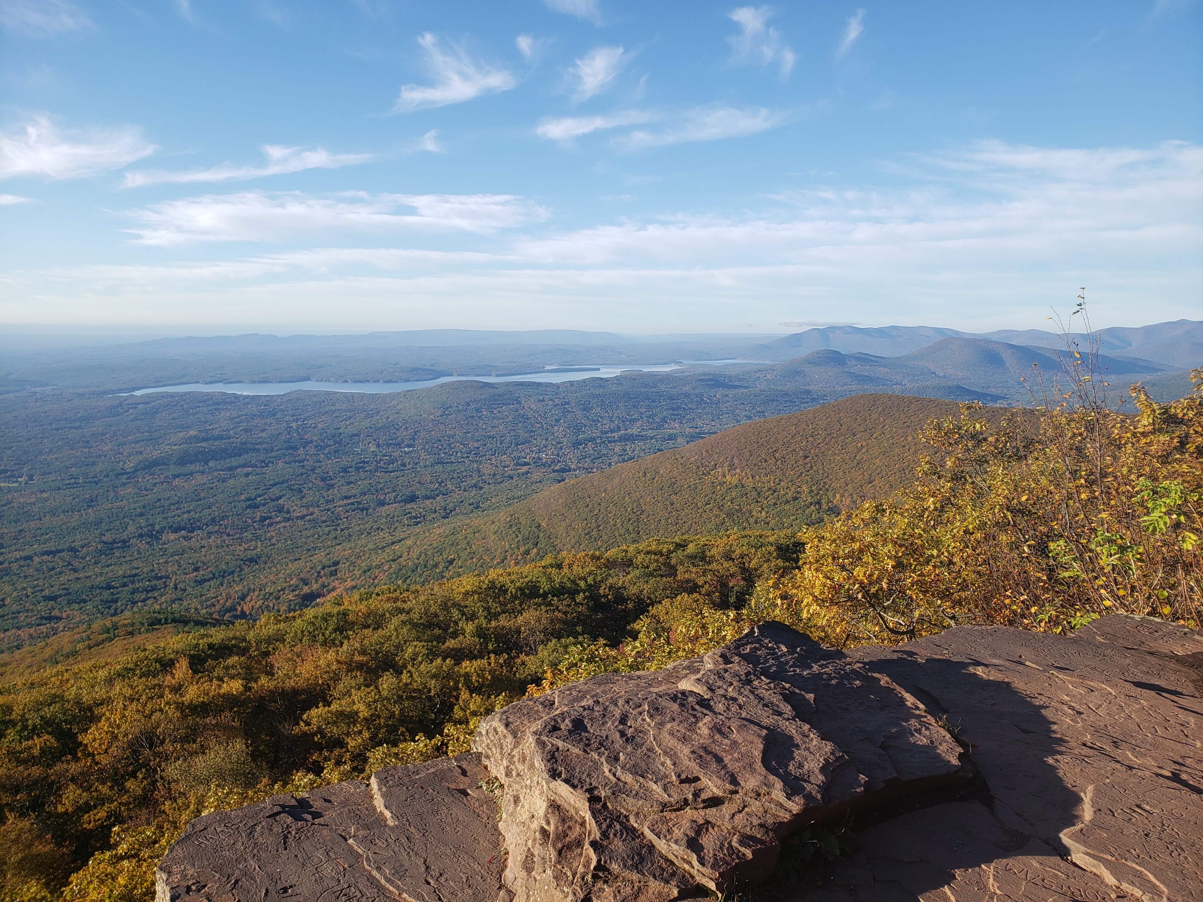
This hike climbs to the Overlook Fire Tower, with spectacular views.

3 hours
Moderate
5 miles
Route type: 
Out and back
Allowed on leash
Historic feature
Views
Historic: 
Catskill Park
Catskills
NY
Ulster
04/02/2024
Driving: 

Take the New York State Thruway to Exit 19 and proceed west on N.Y. Route 28 for 5.9 miles. Turn right and head north on N.Y. Route 375 for 2.9 miles, then turn right onto Mill Hill Road. In 0.5 mile, turn right onto Rock City Road. In 0.6 mile, cross Glasco Turnpike and continue on Meads Mountain Road for 2.0 miles to the parking area at the trailhead. GPS address: 334 Meads Mountain Road, Woodstock, NY 12498.

From the parking area, follow the red-blazed Overlook Spur Trail that ascends Overlook Mountain on a gravel road. You’ll be climbing about 1,300 feet in elevation in the next 2.3 miles, with many views of the surrounding mountains as you climb. 

HOTW Count: 
1

Mount Defiance/Mountain Bike Trail Shorter Loop from Shepherd Lake

West-facing view from Mount Defiance - Photo by Daniel Chazin
NYNJTC maintained: 
1
Summary: 

This loop hike climbs Mount Defiance, with broad west-facing views, and returns on a single-track mountain bike trail.

3 hours
Moderate
4 miles
Route type: 
Circuit
Allowed on leash
Historic feature
Fees
Swimming
Views
Cliffs
Historic: 
Ringwood State Park
Ramapo Mountains
NJ
Passaic
115 North Jersey Trails East
01/15/2021
01/01/2023
Driving: 


Take Skyline Drive to its northwestern terminus at Greenwood Lake Turnpike (County Route 511). Turn right, continue for 1.5 miles, and turn right onto Sloatsburg Road. Continue for 2.1 miles and turn right onto Morris Road. In 1.3 miles, just before the entrance to the Skylands section of Ringwood State Park, turn left onto Shepherd Lake Road and proceed for 0.8 mile to Shepherd Lake. Past the entrance booth, bear left and park in the designated parking area (a parking fee is charged from Memorial Day to Labor Day). NOTE: Shepherd Lake is a popular destination on summer weekends, and the parking area can fill up early in the day.

From the parking area, follow the paved path down to the beach on Shepherd Lake. Continue past the boat launch parking area and the boat house, with the lake on your left. Just beyond the boat house, you’ll notice a kiosk, where an orange-blazed trail begins. Continue on a gravel road along the lake, following both the orange blazes and the red-on-white blazes of the Ringwood-Ramapo Trail.  As you continue along the trail, you may hear gunshot sounds in the distance.

HOTW Count: 
1

Kennedy Dells County Park

Historic: 
Complete: 
Yes
Crum Creek flowing over a breached dam - Photo credit: Daniel Chazin
NYNJTC maintained: 
0

Owned in the early 1900s by the well-known movie producer Adolph Zukor, this 179-acre park offers a fitness trail, hiking trails, horseback riding, a horse corral, nature study, soccer, and cross-country skiing.


Hiking
Bridle path
X-C skiing
Dogs on leash
3 miles
179 acres
Lat/Lon: 
41.168625, -73.988881
New City
Rockland
NY
Cluster/Park: 
Park

Only a small portion of this 179-acre park is developed for active recreation.  Most of the park consists of wooded areas and open fields.  Hiking trails loop around the park, and a 2.4-mile circular hike is possible.  The western boundary of the park is the scenic Crum Creek, paralleled by a trail, and an old road leads down to ruins of a stone dam, stone arches that once supported a bridge over the creek, and a stone pumphouse.


There are two major trails in the park -- the 1.4-mile white-blazed Bridle Path, and the 1.4-mile unblazed Fitness Trail.  These trails can be combined to make a 2.4-mile loop hike around the perimeter of the park.  Although the Bridle Trail is open to equestrian use, it is primarily frequented by canines (accompanied by the owners and other family members). A section of the Bridle Path parallels scenic Crum Creek, the western boundary of the park, and an old road leads down to the remains of a stone dam (now breached), a road bridge over the creek (all that remains are the stone-arch abutments) and a stone pumphouse (with ruins of the machinery still inside). The park features nearly level topography, so the hikes are all easy. Click here for a description of a loop hike in the park.

Use the Web Map link on this site for a trail map.


To reach the park, take NY 304 to Main Street in New City and follow Main Street north for about one mile, past the County Court House, to the park entrance on the left.  GPS Coordinates: 41.168625, -73.988881

Public Transportation: Rockland Coaches

Fees: 
None
Last Update: 
01/28/2017
Modified By: 
Phil McLewin
Landowner: 
County

Leon Levy Preserve

Historic: 
Complete: 
Yes
What remains of the Black Mansion Photo: Jane Daniels
NYNJTC maintained: 
1

Haboring a variety of wildlife, the Leon Levy Preserve has 25-foot high cliffs, extensive wetlands, and hardwood forests. 

Hiking
Bridle path
X-C skiing
Dogs on leash
5 miles
383 acres
Lat/Lon: 
41.260874, -73.530020
Lewisboro
Westchester
NY
Cluster/Park: 
Park
The Leon Levy Preserve is tranquil, scenic, and, adding to the charm of the place, includes a mansion in ruins. The preserve is named in memory of its principal benefactor, Leon Levy. His love of Lewisboro and for nature came together in the purchase of watershed property that local residents had been trying to protect since 1996. Levy, a Wall Street investor, founder of Oppenheimer Funds, and major philanthropist, died in 2003. A family foundation, his widow, Shelby White, and his brother, Jay, provided $5 million of the $8.3 million purchase, completed in 2005.
 

The carriage roads on this former estate have become hiking trails and are wide enough to allow walking two or three abreast. Extensive stonework is apparent on the many at-grade raised roadbeds. 

From I-684, take Exit 6 (Route 35) and turn east. Continue 9.1 miles and turn right at the traffic light onto Route 123 just before the New York-Connecticut line. Continue south 0.3 mile and just after the sign for the preserve, turn right into the parking lot .

No public transportation

Last Update: 
11/10/2016
Modified By: 
Jane Daniels
Landowner: 
Municipality
Manager: 
Town of Lewisboro

Cranberry Lake Preserve

Historic: 
Complete: 
Yes
Quarry at Cranberry Lake Photo: Jane Daniels
Crusher Wall at Cranberry Lake Preserve  Photo: Jane Danielsr
A small quarry Photo: Jane Daniels
Along the shore of Cranberry Lake Oreserve Photo: Jane Daniels
NYNJTC maintained: 
1

Watershed lands are on two sides of Cranberry Lake Preserve. This quiet oasis in suburban Westchester County is also the site of the quarry operations to supply stone to build the Kensico Dam, completed in 1917.

Hiking
No dogs
6 miles
190 acres
Lat/Lon: 
41.075128, -73.756070
Valhalla
Westchester
NY
Cluster/Park: 
Park

Cranberry Lake Preserve

The trail system at the preserve is designed with a novice hiker in mind. The Red and Yellow trails at are loops which allow visitors to follow only one color and return to their starting point. The History Trail is also a loop, often co-aligned with one of those trails. The Blue Trail is no longer a loop because a boardwalk section across South Pond was removed when it became unsafe. Trails that start at the Nature Center lead downhill to the lake. Conneting trails are blazed white or orange. 
From the Bronx River Parkway at the Kensico Dam in Valhalla, take Route 22 north. Once past the dam, make the first right turn onto Old Orchard Street and again the first right to enter the preserve.
 
No public transportation
Last Update: 
11/05/2016
Modified By: 
Jane Daniels
Landowner: 
County
Manager: 
Westchester County Parks
Region - Maintenance: 

Appalachian National Scenic Trail

Complete: 
Yes
New Jersey Boardwalk on the Appalachian Trail - Photo Moe Lemire
Appalachian Trail near Bellevale, NY - Photo Marie-Pierre Castermans
NYNJTC maintained: 
1

A beautiful 162-mile segment of the Appalachian Trail passes through the New York-New Jersey region.


Hiking
X-C skiing
Accessible
Dogs on leash
162 miles
Lat/Lon: 
41.244185, -74.287035
Multiple locations /NY/NJ
Orange
US
Cluster/Park: 
Park

The Appalachian Trail is one of the longest continuously marked footpath in the world, measuring roughly 2,180 miles in length. The Trail goes through fourteen states along the crests and valleys of the Appalachian mountain range from the southern terminus at Springer Mountain, Georgia, to the Trail’s northern terminus at Katahdin, Maine. 

An overview map of the trail along its entire length is available from the National Park “Appalachian National Scenic Trail” web page. 

The AT is uniformly marked with a 2" x 6" white-painted, vertical blaze.

For detailed descriptions of hikes along the AT in NY and NJ click the "Choose another experience" button on this web site.  In the search field enter "Appalachian Trail."  The majority of these are loop hikes in conjunction with other trails.  For AT-only hikes click here. The database includes a few AT hikes in nearby sections of Pennsylvania and Connecticut. 

Two of the few wheelchair accessible sections from Georgia to Maine are in this region:


Driving:

Parking is available in all the parks listed on this site that host a segment of the AT.   One spot identified on this web page is where the AT crosses NY-17A  near Warwick, NY.  GPS Coordinates: 41.244185, -74.287035.

On the Appalachian Trail Region page look for the link “Parking along the AT.”  It features parking areas organized by state.

Public Transportation:

Hike descriptions that include the AT will indicate if public transportation (train or bus) is available to a particular trailhead. 

The AT crosses the Metro-North Railroad’s Harlem Line at the Appalachian Trail station (just off N.Y. Route 22, between Pawling and Wingdale) -- the only train station located directly at an AT crossing anywhere along the 2,180-mile-long trail!  Limited service is provided at the Appalachian Trail station, with trains stopping there only on Saturdays, Sundays and holidays (the station, which is little more than a low-level platform, is not wheelchair accessible).  At other times, hikers may board trains at Pawling (to the south) or Harlem Valley-Wingdale (to the north).  Trains run north to Wassaic and south to Grand Central Terminal in New York City.


Fees: 
Some times and places; check with park
Last Update: 
02/26/2017
Modified By: 
Phil McLewin

Taxter Ridge Park Preserve

Historic: 
Complete: 
Yes
Chimney from Woodycrest Photo: Jane Daniels
NYNJTC maintained: 
1

In the midst of heavily traveled highways and bordered by residential areas, Taxter Ridge Park Preserve is a large green oasis providing enjoyable hiking though beautiful woods. 


Hiking
Dogs on leash
2 miles
190 acres
Lat/Lon: 
41.059352, -73.846266
Town of Greenburgh
Westchester
NY
Cluster/Park: 
Park

Considered by some to be the gateway to Westchester County, Taxter Ridge Park Preserve is an excellent example of how concerned citizens rallied to protect a large tract of open space in southern Westchester County. The horse-shoe shaped park has a landscape featuring natural rock ledges, woodlands, streams, wetlands and old growth forest. The 190 acre park is jointly owned by New York State, Westchester County and the Town of Greenburgh with the latter providing maintance.


There are three blazed trails in the preserve:

Hike in from parking on Mt Pleasant Lane and follow an easy trail (blue blaze) through wooded forest for 1.4 miles. The trail passes by a 250 year-old oak tree and a deep ravine.

From parking on Sheldon Avenue in Tarrytown, hike a more challenging trail (orange blaze) for 0.9 mile that meanders up and down hills. Initially it is on a graded woods road. A bit after it becomes a single track, until it meets the blue-blazed trail from Mt Pleasant Lane.  Sections away from the NYS Thruway are quiet.

A third 0.2-mile trail (yellow blaze) from Taxter Road in Greenburgh is not open, but will lead from a proposed parking lot to be built but as of 2016 funds are still lacking. 


To reach the Sheldon Avenue trailhead (at end of a dead end road)

  • From westbound I-87-I287 take the Route 119 Exit (last exit before toll). Turn left onto Route 119 and when it ends at Route 9, turn left again just past the east bound I-87/I287 exit/ entrance ramp. Turn left on Walter Avenue. Go left again on Sheldon Avenue and follow it 0.5 mile to the end.  
  • From east bound I-87/I-287, stay in the right hand lane when approaching the tolls of the Tappan Zee Bridge. Take Exit 9, Route 9 and turn left at the bottom of the ramp. Take the next left and follow the directions above from.
  • GPS Coordinates: 41.059242,-73.84747

The Mt. Pleasant Lane trailhead (on-street parking in a cul-de-sac)

  • From Route 9 in Tarrytown, turn east on East Sunnyside Lane which is opposite the road to Sunnyside historic site. Go 0.6 mile and make a slight left onto Taxter Road. Take the first left onto Pine Lane and left again to Mt. Pleasant Lane. Park in the cul-de-sac near the sign.
  • GPS coordinates: 41.048751,-73.849461

No public transportation

Fees: 
None
Last Update: 
11/09/2016
Modified By: 
Jane Daniles
Landowner: 
Partnership
Manager: 
Town of Greenburgh

Paterson Great Falls National Historical Park

Historic: 
Complete: 
Yes
NYNJTC maintained: 
0

The park commemorates “The Cradle of American Industry."

Hiking
Accessible
Dogs on leash
35 acres
Lat/Lon: 
40.9144289, -74.1802668
Paterson
Passaic
NJ
Cluster/Park: 
Park

The Great Falls of the Passaic River, located in Paterson, N.J., is the site of an early, successful initiative to establish a “national manufactory” in post-revolutionary America.  As part of the Mercantilist vision of Alexander Hamilton, the country’s first Secretary of the Treasury, Paterson become America’s earliest planned industrial city with the incorporation of the Society for Establishing Useful Manufactures (S.U.M.) in 1791.

Great Falls in Winter (NPS photo)The National Park Service offers Guided Introductory Tours seasonally -- it takes roughly one hour and covers one mile.  See the Park's website link in Contact Information on this site for a schedule, follow the "Plan a Visit" tab. 

“Trails” largely consist of city sidewalks with uneven surfaces.  A pictorial map of the park (use Web Map link on this site)  identifies such major features as the Great Falls, mills (both standing and in ruins), the S.U.M. Hydroelectric Station, the upper, middle and lower raceways, street names (for navigation), smaller local parks, cultural centers, several public parking areas, and (important in an urban setting) public restrooms. 

The self-guided Mill Mile tour starts introduces visitors to the remarkable history, geology, social and cultural importance of the area. 

An on-line brochure describing the 10-stop tour – which includes a map -- is available, as is a free downloadable audio tour app (from I-Tunes and Google Play Store) and a number to call using a cell phone along the way.   The Tour is an educational project of the Hamilton Partnership for Paterson.  

To complement a visit with a more woodsy hiking experience, Rifle Camp Park and Garret Mountain Reservation, two interconnected Passaic County parks just a short drive from the mill district, have a combined trail network of 13 miles on roughly 800 acres of parkland. 


From I-80 West, take Exit 57 B-A. Follow the Downtown Paterson signs. Turn left at second light onto Cianci Street, and left at first light onto Market Street for 1/4 mile. Turn right onto Spruce. Go one block and turn right onto McBride Avenue Extension, then immediately left into Great Falls Overlook parking area.

From I-80 East, take Exit 57 B, circle onto Grand Street exit. At end of exit ramp turn left onto Grand. At second light on Grand turn right onto Spruce Street. At second light on Spruce bear right onto McBride Avenue Extension, then turn immediately left into the Great Falls Overlook parking area.

NJ Transit Bus Route 161 connects the 42nd Street Port Authority Bus Terminal with Paterson, stopping near the NJ Transit train station.


Fees: 
None
Last Update: 
06/26/2017
Modified By: 
Phil McLewin
Landowner: 
NPS
Manager: 
973.523.5295; [email protected]

Mount Beacon Park

Historic: 
Complete: 
Yes
View from North Mount Beacon - Photo credit: Daniel Chazin
NYNJTC maintained: 
0

Spectacular views reward a steep climb to the historic summit of Mount Beacon.

Hiking
Mountain biking
Dogs on leash
2 miles
234 acres
Lat/Lon: 
41.493669, -73.959846
Beacon
Dutchess
NY
Cluster/Park: 
Park

Mount Beacon Park

Mount Beacon can be seen from miles around and is the northern gateway to the Hudson Highlands. In 1995 and 1998 Scenic Hudson, the City of Beacon and the Town of Fishkill purchased these lands which were threatened by development.

The mountain has a long history, beginning with its use for signal fires during the Revolutionary War. From 1902 to the late 1970s, it was the site of the famous Mount Beacon Incline Railway, which visitors rode to the Beaconcrest Hotel and Casino for dining, dancing and outstanding views.

The Casino Trail (Red blaze, 2.0 miles) begins at the parking area Kiosk and gains 2,000 feet in elevation, passing several viewpoints in its climb to the summit.  

A Yellow-blazed trail turns north from its junction with Casino Trail and climbs to the Fishkill Ridge.

By linking with White and Blue blazed trails to the Scofield Ridge and the Wilkinson Memorial Trail, the hiker can do a strenuous 8.0-mile circular walk.

Use Web Map link for a trail map.

From NY Route 9D, look for Bob's Corner Store in Beacon. Turn east onto Howland Avenue. then immediately turn right into the parking area for Scenic Hudson's Mount Beacon Park.  GPS Coordinates:  41.493669, -73.959846

Public Transportation: Metro-North Hudson Line to Beacon station -- walk uphill to trailhead

Fees: 
None
Last Update: 
01/16/2017
Modified By: 
Phil McLewin
Landowner: 
Private

Yellow-Silver/Schuber/Cannonball Trail/Bear Swamp Lake Loop

MacMillan Reservoir - Photo by Daniel Chazin
NYNJTC maintained: 
1
Summary: 

This loop hike traverses less-used portions of the reservation, climbing to a viewpoint over Bergen County and the Manhattan skyline and passing several lakes.

5 hours
Moderate to Strenuous
9 miles
Route type: 
Circuit
Allowed on leash
Views
Waterfall
Historic: 
Ramapo Valley County Reservation
Ramapo Mountains
NJ
Bergen
115 North Jersey Trails East
06/06/2008
11/14/2018
Driving: 

Take N.J. Route 17 to U.S. Route 202 in Mahwah. Turn left at the bottom of the ramp, proceed south on Route 202 for two miles, and turn right into the Ramapo Valley County Reservation parking area.

Bus: 

Short Line offers bus service from Port Authority Bus Terminal in New York City to Ramapo College, which is located about a mile to the north of the park entrance on Route 202. For schedule information, go to www.shortlinebus.com. Only limited service is available on weekends.

The hike begins at a kiosk in the southwest corner of the parking area. Just ahead, you'll notice a triple-black-square-on-yellow blaze on a tree, which marks the start of the Vista Spur Trail. Follow the black-square-on-yellow blazes as they descend wooden steps, join a wide dirt road, and continue ahead to cross the Ramapo River on a steel truss bridge.

Reference/Source: 
Bergen Record: Hike of the Week