1. New York City to NY-NJ State Line
Section 1: New York City to NY-NJ State Line
Quick Facts
Distance: 14.1 miles
Parks: GWB Northwalk, Palisades Interstate Park
Maps: Interactive Map, Hudson Palisades Trails (maps 108 and 109)
Print-Friendly Version: Link
General Description
After crossing the George Washington Bridge, the Long Path follows the crest of the spectacular Palisades Escarpment on the western bank of the Hudson River near New York City, wandering between the cliff edge and the Palisades Interstate Parkway. The route affords stunning views of the basaltic face of the Palisades, the Hudson River and the City of New York and its suburbs. The trail passes through rich forests, with occasional streams and swamps. Old roads, rock walls and foundations along the route are remnants of past settlement along the Palisades. Several side trails lead down to the Shore Trail along the Hudson River. These allow the hiker to make a number of interesting circuits. The trail is generally wide and nearly level (except for some steep sections near the New York-New Jersey border). Unfortunately, the trail is almost always within sound of the Palisades Interstate Parkway. In 1971, this section of the Long Path was designated a National Recreational Trail by Secretary of the Interior, Roger C. B. Morton.
Access
From New York: Take the A train to the 175th Street station.
From New Jersey: Take any road, including the Palisades Interstate Parkway, I-95, NJ 4 and US 1-9, that leads to the George Washington Bridge (GWB). The trail starts on the New York side of the GWB.
By public transportation: Take any bus to the GWB bus terminal and walk over the bridge.
Parking
1.50 Fort Lee Historic Park, just south of the bridge (metered parking). (40.85181°, -73.96245°)
1.55 Street parking along Hudson Terrace (free on Sundays and holidays; meters on other days). (40.85430°, -73.96322°)
2.95 Allison Park (when open). (40.86978°, -73.95259°)
4.85 Rockefeller Lookout (20-minute limit). (40.89225°, -73.94119°)
8.05 Alpine Lookout (20-minute limit). (40.93013°, -73.92690°)
9.80 Alpine headquarters PIPC. (40.95337°, -73.92067°)
11.85 Parking, 0.2 mile from the Long Path, along Route 9W in Alpine near overpass leading to Women's Federation Monument. (40.97989°, -73.91352°)
12.60 State Line Lookout (metered parking) (40.98888°, -73.90662°)
Parking is also available at Ross Dock and the Englewood and Alpine Boat Basins on the Hudson River (metered parking in season); side trails lead up to the Long Path.
Trail Description
0.00 The Long Path starts in New York City at the 175th Street subway station in Washington Heights (Manhattan). Once at the station, exit to Fort Washington Avenue at either W 175th Street or W 177th Street, and head north (uptown) on Fort Washington Avenue.
0.05 The Long Path would follow the Southwalk across the George Washington Bridge, but the Southwalk is closed for construction as of 2023, so it temporarily follows the Northwalk to cross the Hudson River. Continue past W 178th Street under the GWB roadway and past the GWB Bus Station.
0.15 Turn left onto W 180th Street.
0.25 Cross Cabrini Boulevard and enter the Northwalk. Note that while the Southwalk is under construction, the Northwalk has both pedestrian and bike traffic. Follow the Northwalk across the Hudson River.
1.50 Reach the western end of the George Washington Bridge, climb a flight of stairs (the Northwalk does continue ahead along a long ramp), turn right onto the top of the ramp and then immediately turn right again and climb another short flight of stairs. The Long Path continues on a wide gravel road, bearing left at a fork.
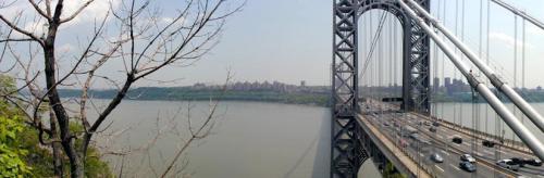
Manhattan and the George Washington Bridge. 2001 [TODD SCHREIBMAN]
2.05 At the last of several signs for "Trail to River," the Carpenter's Trail (blue on top and white on the bottom) heads right, leading to the Shore Trail (white). The Long Path continues to the left on a narrower track near the cliff edge. In 300 feet, a side trail (white on top and blue on the bottom) leads left to a footbridge over the Palisades Interstate Parkway. The Long Path continues on past the former site of an old mounted cannon from the Spanish-American War. The trail then goes by several old stone walls and crosses a stream.
2.70 The trail passes a gas station (water, vending machines, food, phone) on the left and then crosses a stream after a short while.
2.95 The trail passes to the left of the iron fence surrounding Allison Park to reach the entrance to Allison Park. This park was developed by the trustees of the Estate of William O. Allison (1849-1924), who was born and spent his life nearby.* When open, the park offers water, restrooms, phone, and overlooks. The Long Path continues along the paved access road to the park, passes the entrance road to Sisters of St. Joseph of Peace, and enters a narrow strip of woods near the Parkway. It briefly follows the Parkway's shoulder before heading back toward the edge of the Palisades' cliffs on what becomes an abandoned asphalt drive.
3.65 The trail descends steps to Palisade Avenue, turns right, turns left at the corner and goes up another set of steps to the right. Nearby, the Dyckman Hill Trail (yellow) starts down the Palisades to the Englewood boat basin, leaving the Long Path, which turns left to follow the cliff edge. Views across the river include the Henry Hudson Bridge over the Harlem River and Manhattan's Inwood Hill Park. The medieval-looking monastery is the Metropolitan Museum of Art's Cloisters.
4.30 As the Long Path turns left, an unmarked trail straight ahead leads to the High Tom promontory with its magnificent views up the river.
4.80 The Long Path reaches Rockefeller Lookout and its tremendous views. Not long after, it crosses a small stream and briefly follows an old gravel road. There are many fine river views. Clinton Point, reached by a short walk toward the right away from the Long Path immediately after it passes an open area, is one of the best viewpoints. Just after the trail crosses another stream, reach the fence for the Greenbrook Sanctuary on the right of the trail.
6.65 The trail crosses the entrance road to the Greenbrook Sanctuary. The Sanctuary, open to interested parties by membership, preserves a splendid example of the forests and other habitats that once ranged along the top of the Palisades. The Long Path continues along the Sanctuary's fence, twice plunging below the grade of the Parkway to cross over streams that run through woodland swamps.
7.50 The Huyler's Landing Trail (red), which connects to the Shore Trail (white) at the Hudson's edge, leads right at a very sharp angle shortly after leaving the Sanctuary fence. The Long Path then returns to the edge of the Palisades.
8.00 Reach Alpine Lookout, with many fine views. The trail runs past the lookout point and enters the woods at the end of the cliff-edge railing. It then passes a series of old stone walls and foundations and travels briefly on an old road as it meanders between the Parkway and the cliff edge. It is never far from either, but there are plenty of river views.
9.40 A tunnel leaves to the left under Palisades Interstate Parkway to US Route 9W. The Closter Dock Trail (orange) joins from the left and continues jointly with the Long Path for the next 0.2 mile.
9.60 The trail uses a tunnel to pass below Alpine Approach Road. Immediately after the tunnel, the Closter Dock Trail (orange blazes) leads right and down the hill to the Alpine Boat Basin. The Long Path shifts left at this point and exits the woods. (For reverse direction, a sign reading "Path to River" shows where the Long Path leaves the paved road and enters the woods.)
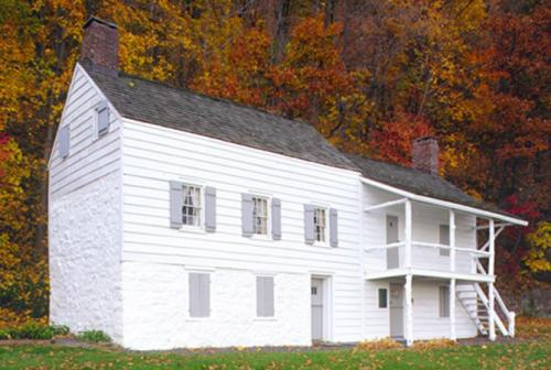
Blackledge-Kearny house at Alpine Boat Basin. 2001 [MICHAEL WARREN]
=
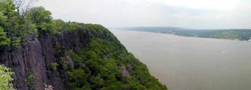
View from the Palisades. 2001 [TODD SCHREIBMAN]
9.80 The trail passes the headquarters of the New Jersey section of Palisades Interstate Park. There are water, telephone, bathroom facilities, and information about the Park and Greenbrook Sanctuary in the Park Commission headquarters building. The Long Path enters the woods on a wide path at the north end of the headquarters parking lot, past the building. Once in the woods, it goes through a variety of hardwood and hemlock forests that afford river views, some quite fine.
11.55 The trail reaches the end of a dirt road - the abandoned portion of Ruckman Road. To the right is an overlook above the Hudson (with a concrete block wall). The Long Path turns left on Ruckman Road and, in another 50 feet, turns right on a gravel road into well-developed forest. A short distance beyond, another gravel road leads right to run along the cliff edge. This road, not part of the Long Path, ends in about 900 feet at the terminus of a great split off the main face of the Palisades. With its many splendid views, it makes a worthwhile excursion.
11.75 The trail turns right on a narrow gravel road.
11.85 The Long Path reaches a second gravel road. The left branch, marked with blue-and-white rectangles, leads to a footbridge over the Parkway to parking on 9W and to the Bergen Boy Scouts Council's Camp Alpine. To the right, these markers run concurrently with the Long Path.
11.90 Reach a clearing with stone monument shaped like a castle, a reminder of the preservation works of the New Jersey State Federation of Women's Clubs. They played an instrumental part in creating Palisades Interstate Park at the beginning of the 20th century. Beyond the clearing, the trail descends on rock steps.
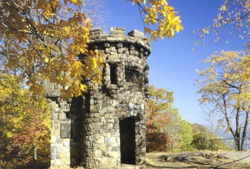
Women's Federation Monument. 2001 [MICHAEL WARREN]
12.10 The blue-and-white trail, now called the Forest View Trail, leaves to the right and descends to the river to connect with the Shore Trail (white). The Long Path continues ahead to cross a stream on a bridge and begin an ascent on steps to reach the concrete access road to State Line Lookout. (This road was originally part of US Route 9W).
12.20 Cross the road, and continue on cross-country Ski Trail A, which is marked with aqua blazes.
12.50 Turn right on Ski Trail F.
12.60 The State Line Lookout snack bar, with restrooms, food, water, phone, and bookstore, is on the right. The concession is open all year. Beyond the snack bar is Point Lookout on top of Indian Head, the highest point in the New Jersey section of Palisades Interstate Park. The trail turns left just before reaching the snack bar, and reaches the old Route 9W in 150 yards. Turn left on the road.
12.80 The Long Path bears right into the woods on Ski Trail E, just past the end of the rock wall along the roadside.
13.30 Continue straight ahead as cross-country Ski Trail E turns left. In another 300 feet, the Long Path turns right, up four steps, and continues on a narrower path. It turns right at a chain-link fence marking the New Jersey-New York state boundary (to the left, there is a stone boundary monument placed in 1882). The trail descends along the fence on stone steps, turns left, and passes through a gate in the fence to enter New York. It continues to descend on steps, often quite steeply, close to the edge of the cliffs.
13.60 The steps end and the Long Path turns left to descend more gradually to a stream crossing.
13.75 The Shore Trail (white) goes right and follows the stream for 0.75 mile to a beautiful cascade and remnants of Lawrence Garden (or Italian Garden, designed after a garden in Amalfi). The Long Path turns left to follow the stream uphill, ascending gently but steadily. Another unmarked trail leaves to the left 0.2 mile farther along the Long Path as the ascent ends.
14.10 The Long Path reaches US Route 9W at the entrance road to Lamont-Doherty Earth Observatory, just north of the New Jersey-New York state line. To continue, turn right on the entrance road, then turn left at the guard house.
Previous Section: None
Next Section: Section 2
* William O. Allison was a native of the small group of small fishing villages that developed at the base of the Palisades during the 19th century. He was born in Undercliff Village in 1849 and became a successful journalist in his early twenties. He started a trade journal (the Oil, Paint, and Drug Reporter) and became very successful at acquiring more trade journals, making him a wealthy man. In his later years, he interviewed old-timers from the Undercliffs, but a large part of his historical collection burned along with his mansion in 1903. The trustees of his estate established Allison Park, and some of the land he owned is now a part of the Flat Rock Brook Nature Center in Englewood.