The Hudson Highlands
The Long Path makes its first foray into genuine mountains as it passes through the Hudson Highlands. It is the first time that the trail reaches higher than 1000 feet elevation above sea level. As part of its journey north through this region, it traverses the length of two major New York State Parks, Harriman, one of the oldest, and Schunemunk Mountain, one of the newest. It also enters a part of New York State that is steeped in Trail Conference history. Many of the trails created by the Trail Conference in its infancy are contained in Harriman and Bear Mountain State Parks. The very first section of the Appalachian Trail lies in Harriman and that first section crosses the Long Path near Island Pond Mountain in Section 6. There are many, many trails throughout the Harriman and Bear Mountain State Parks, making endless loop possibilities incorporating portions of the Long Path.

Turkey Hill Lake from Long Mountain. 2001 [JAKOB FRANKE]
5. Mt. Ivy to Lake Skannatati
Section 5: Mt. Ivy to Lake Skannatati
Quick Facts
Distance: 9.4 miles
Parks: Burgess Meredith Park, Cheesecote Mountain Town Park, Harriman State Park
Maps: Interactive Map, Harriman-Bear Mountain Trails (map 118)
Print-Friendly Version: Link
General Description
The Long Path heads north along the Palisades Interstate Parkway for about a mile, crosses the South Branch of Minisceongo Creek, turns west, and climbs up the side of Cheesecote Mountain before descending past Cheesecote Pond and Letchworth Village Cemetery. The trail briefly follows Call Hollow Road before turning west into Harriman State Park. Harriman State Park is a stunningly beautiful preserve of lakes, hemlock and hardwood forest, historical trails and sites, wetlands, mountains and ridges. On the portion of its route through the Park covered in this section, the Long Path keeps largely to gentle grades until it reaches Lake Skannatati.
Access
This section begins in the parking lot of South Mountain County Park on the east side of NY Route 45, near Exit 13 of the Palisades Interstate Parkway. The trail turns west off Call Hollow Road, about 1 mile west of Exit 114 of the Palisades Interstate Parkway. The section ends at a fishermen's access parking area beside Lake Skannatati on Seven Lakes Drive, about 0.75 miles north of Kanawauke Circle.
Parking
0.00 Parking area off NY Route 45, 0.15 miles south of US Route 202. (41.18434°, -74.03635°)
2.60 Cheesecote Lane in Pomona, off North Ridge Road (3-4 cars). (41.20788°, -74.04574°) A 0.1-mile unmarked path leads to the Long Path near Cheesecote Pond.
3.60 Along Call Hollow Road. (41.21814°, -74.04881°)
9.40 Lake Skannatati parking area. (41.24198°, -74.10243°)
Camping
5.65 Big Hill Shelter
Trail Description
0.00 Turn right (north) from the parking lot of South Mountain County Park onto NY Route 45
0.15 At the intersection of NY Route 45 and US Route 202, turn left (west) on Route 202.
0.20 At the next light turn right at the pedestrian crossing. It pays to wait for the light; traffic can be very heavy on Rte 202. Once on the northside of Rte 202, turn left. Be careful, you have to cross Thiells Mt. Ivy Road, which also is an off-ramp for the northbound Palisades Interstate Parkway. Proceed west along the northside of Rte 202, and immediately after passing underneath the Parkway, turn right. The trail goes into the woods for a moment, then emerges to cross the on and off ramps of the Parkway southbound lanes. Be careful: traffic moves fast here!
0.40 The trail makes a short right-left jog and enter the woods at a small pine grove. The turn is indistinctly marked. The trail follows a narrow strip of land between the Palisades Interstate Parkway on the right and a chain-link fence on the left.
0.60 The trail passes under a power line and continues north along the narrow strip.
1.20 The route becomes very swampy as you reach a corner in the chain-link fence. It veers to the left away from the trail.
1.35 The trail turns right onto a grassy woods road, and in a few hundred feet turns left to continue on the bank of the South Branch of Minisceongo Creek.
1.55 Walk along the top of a stone arch over the South Branch of the Minisceongo Creek that carries the creek under the Parkway. Continue along a small tributary stream for approximately 75 yards. Cross the stream, turning away from the Parkway, to intersect a woods road. Turn right onto the road and ascend gently through a hardwood forest along a hill slope. You are entering Cheesecote Park in the Town of Haverstraw.
1.70 The trail turns left and heads up the hill. The grade moderates and the trail continues uphill, with many turns along the way.
2.00 Turn left on a grassy woods road and continue uphill. The road changes from grass to cinders. For the next 1.6 miles until Call Hollow Road, many dirt roads diverge from the road that the Long Path follows. However, the trail stays with the largest and most developed road as it twists and turns.
2.45 Reach the crest of a knob on the shoulder of Cheesecote Mountain and begin to descend, still on the woods road.
2.55 Reach Cheesecote Pond and turn left. The trail goes along the side of the pond, keeping the pond on the right. Turning right there is a camping area (permit required).
2.70 Reach a large turnaround at the southwest corner of the pond. The trail bears left and uphill for a short distance, away from the pond. It then begins a steady descent and changes to a rough cobble base.
3.00 Bear left at a Y-intersection and follow the steeper road downhill.
3.40 Shortly after crossing a power line right-of-way, the trail reaches Letchworth Village Cemetery. The Long Path turns left and skirts the cemetery, then turns left again at an intersection of gravel roads. The grade levels off.
3.60 Reach Call Hollow Road and turn left along the pavement.
3.70 Turn right, leaving the road, and re-enter woods. The trail crosses Horse Chock Brook. The bridge across Horse Chock Brook that had been wiped out by Irene in 2011 has been rebuilt in March 2013 by an Eagle Scout. After crossing the brook, make a short ascent up the slope to meet a woods road. The trail turns left to follow the road.
4.25 After a brief drop into the valley of an intermittent stream, the Long Path veers right on a narrow track to ascend the valley while the woods road continues left across the valley. The trail crosses the stream and a rock wall as it continues to climb.
4.50 Reach a crest. From here it is a short drop and rise to the crest of another small knoll.
4.65 The Long Path reaches the dirt road of an AT&T buried telephone cable right-of-way. Cross the road and enter the woods on the other side. After 250 feet, turn right onto an old woods road headed toward a stream. Cross the stream (last sure water before Big Hill Shelter) and turn left as the trail begins a gradual climb.
5.00 Continue climbing over open rock with a seasonal view of the Hudson behind you.
5.10 Pass a small swamp on the left. It may be dry in summer.
5.25 After passing some small glacial erratics, the Long Path enters mountain laurel, turns left and begins a gradual downhill.
5.40 Turn left as the trail drops downhill.
5.45 Reach an intersection with the Suffern-Bear Mountain Trail (SBM) (yellow). The Long Path and SBM continue jointly over ledges to climb up to Big Hill Shelter. The woods road leading left from this junction leads to Second Reservoir.
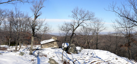
Big Hill Shelter. 2008 [JAKOB FRANKE]
5.70 Arrive at Big Hill Shelter. Built in 1927, this stone shelter has three fireplaces. The Long Path veers right at the shelter as the SBM continues straight ahead. The Long Path follows a fire road back to the AT&T right-of-way.
5.85 Cross AT&T right-of-way and continue through laurel.
5.95 Begin a short climb up a grassy slope.
6.10 Turn right onto a woods road.
6.15 Cross an intermittent stream on the rocks and contour around a small hill.
6.40 The trail passes just to the north of a 727 plane crash site. Northwest Airlines flight 6231, chartered by the Football Baltimore Colts, took off from JFK airport to pick up the team in Buffalo, NY. During take off an ice storm caused their instruments to provide inaccurate airspeed readings, the plane stalled and crashed here in Harriman Park on December 1, 1974. All 3 crew members [Captain John B. Lagorio, First Officer & Co-Pilot Walter A. (Jim) Zadra, and Second Officer James (Jim) F. Cox, Jr.] lost their lives. This tragic accident drove changes in airline training throughout the world, making flying safer for everyone. Please do not remove items from this site, as it is a memorial to those who lost their lives here.
6.60 After passing through a boulder field, turn right on an old woods road. The trail passes under a telephone line and then through a red pine grove before descending through a swamp, crossing its outlet on a wooden bridge. The trail goes up and down through a hardwood forest rich in oak. Note: The USGS Thiells topographic map of the area from mile 7.15 to mile 8.00 is well out-of-date and shows incorrect road locations.
7.05 The Long Path makes a left turn uphill. Straight ahead, an unmarked trail leads in 0.15 miles to St. John's-in-the-Wilderness Church, the site of the hiking community's annual Palm Sunday pilgrimage.
7.55 Turn right and, in 250 feet, cross a grassy road. (In the opposite direction, one must bear right a bit when crossing the road.) The trail becomes wide and grassy as it approaches Lake Welch Drive.
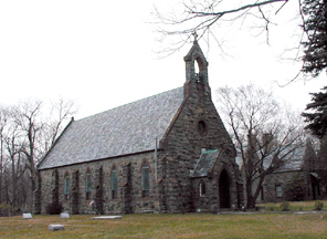
St. Johns-in-the-Wilderness Church . 2001 [TODD SCHREIBMAN]
7.70 Cross Lake Welch Drive near its intersection with St. John's Road (formerly Johnsontown Road).The Long Path ascends on an old woods road, at first steeply and with several turns, through open, glade-like forest.
7.90 Bear right, still heading uphill, as another woods road goes left. In 200 feet, the trail turns left on a narrow path as the woods road continues straight ahead. After crossing a rock wall, the trail reaches an open knoll with an old stone foundation on the left and cellar holes on both sides of the trail. This was the site of the Charles Conklin farm. Once past the foundation, the trail enters brushier woods and begins to descend.
8.25 The Beech Trail (blue) starts to the right. A few hundred feet farther on, an unmarked trail goes off to the right as the Long Path bears left and begins to descend to an intermittent stream.
8.80 Cross the rocky outlet stream of a large marsh that is all but hidden to the right. The trail continues on a grassy woods road.
8.90 Reach Rockland County Route 106 (also known as Gate Hill Road or Old Route 210), turn right and follow the road for 250 feet. The trail then crosses the road and heads diagonally uphill into the woods. Not long after, it makes a left turn onto a woods road. Cross under a telephone line. Two additional left turns bring the trail past the south end of Lake Askoti.
9.35 Reach Seven Lakes Drive. Turn right, cross the bridge over the outlet of Lake Askoti and enter the woods on the opposite side of the road, across the guard rail. The trail descends along the stream and swings to the right, passing Lake Skannatati on the left.
9.40 The trail reaches a paved parking lot beside the lake. To continue, follow the shore of Lake Skannatati north through the parking lot.
Previous Section: Section 4
Next Section: Section 6
6. Lake Skannatati to US Route 6
Section 6: Lake Skannatati to US Route 6
Quick Facts
Distance: 10.15 miles
Parks: Harriman State Park
Maps: Interactive Map, Harriman-Bear Mountain Trails (map 119)
Print-Friendly Version: Link
General Description
This section of the trail continues through Harriman State Park. The Long Path crosses many woods roads and other trails within the park, making possible various loop hikes. The trail traverses hemlock forests and rhododendron groves, and passes by large swamps. It then climbs and follows along the long, linear ridge of Stockbridge Mountain. Upon descending from the mountain, the trail passes another swamp before reaching US Route 6.
Access
To reach the beginning of the section from the New York State Thruway, take Exit 15 (Suffern). Continue north on NY Route 17 to Sloatsburg. Just north of the village, turn right onto Seven Lakes Drive. This section starts at the fishing access parking lot off of Seven Lakes Drive at Lake Skannatati, about 0.75 mile north of Kanawauke Circle. From the Palisades Interstate Parkway, take Exit 15, go west on Gate Hill Road and Rockland County Route 106 to Kanawauke Circle, and then go north for 0.75 mile on Seven Lakes Drive.
Parking
0.00 Lake Skannatati parking area. (41.241979°, -74.102427°)
5.75 Tiorati Circle picnic area, about 0.5 mile east of the Long Path crossing of Arden Valley Road (fee charged seasonally). (41.275190°, -74.089036°)
10.15 Parking area off Route 6. (41.315976°, -74.050148°)
Camping
4.45 Cohasset Shelter
8.00 Stockbridge Shelter
Trail Description
0.00 The section begins at the Lake Skannatati parking area off Seven Lakes Drive. Follow the shore of Lake Skannatati north through the parking area. At the northeast end of the lake, where the Arden-Surebridge Trail (A-SB) (red triangle on white) starts on the right, turn left into the woods and follow the north shore of the lake. About halfway along the north shore, the Long Path veers away from the lake, goes over a small ridge and drops back to the west arm of the lake. After undulating up and down along the lake's western shore, the trail crosses the lake's swampy inlet stream and begins a series of longer ups and downs.
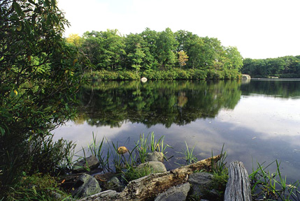
Lake Skannatati. 2001 [MICHAEL WARREN]
1.25 The Long Path turns left and joins a woods road, the route of the Dunning Trail (yellow). In 250 feet, the Long Path turns right on a footpath, as the Dunning Trail continues along the woods road. The Long Path goes over a grassy ledge perched on a hill slope and passes a shaft of the abandoned Hogencamp Mine, one of the largest iron mines inside the Park boundary. Stone foundations on the side of the trail are remnants of this mining community.
1.40 The trail turns right near an overhanging rock, known as Cape Horn, to continue up an old stone-lined road. After passing through a saddle, the trail begins to descend through forest rich in hemlock and mountain laurel. It joins an old woods road, the continuation of the Surebridge Mine Road.
2.00 Reach Times Square, the junction of the Long Path, the A-SB Trail (red triangle on white) and the Ramapo-Dunderberg Trail (red dot on white). The Long Path continues west jointly with the A-SB Trail on the Surebridge Mine Road through fairly level terrain.
2.10 The Long Path and the A-SB Trail turn left, leaving Surebridge Mine Road, and rise gently through a forest of hemlock and white pine. Surebridge Swamp becomes visible below on the right. The trail now alternates through laurel, hardwoods, hemlocks and large rhododendrons.
2.60 The Lichen Trail (blue L on a white square) starts to the left as the Long Path and A-SB continue on a downgrade to pass a swampy area on the right. The trails approach and veer away from a hemlock swamp and then run along the swamp's intermittent outlet stream before crossing the stream. The descent ends as the combined trails begin to pass a marsh on the right.
2.90 The White Bar Trail (horizontal white rectangle) starts to the left. In another 30 feet, the Long Path turns right as the A-SB continues straight ahead along the side of a marsh. The Long Path crosses an outlet stream and runs between the marsh and a steep, hemlock-covered slope. Upon reaching the head of the marsh, which becomes a wooded swamp, the trail follows an inlet stream. The trail then turns left and uphill, away from the stream.
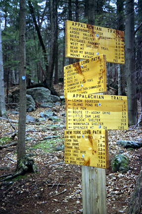
3.60 Cross the Appalachian Trail (vertical white 2x6 rectangle) in a slight dip at a prominent signpost. The sign has distances to various landmarks on both the Long Path and Appalachian Trail routes. The Long Path now rises to a broad knob, dips to a marsh, and climbs a knoll.
Appalachian Trail Junction. 2001 [ED WALSH]
4.30 The trail reaches the top of the knoll and begins to descend, passing a partial view of Upper Lake Cohasset on the way down.
4.45 Pass Cohasset Shelter (no water), on the left as the descent continues. This shelter was built in 1937 for the girls' camps on Upper Lake Cohasset. The trail crosses Surebridge Mine Road and, in another 0.25 mile, crosses a stream leading from a marsh on the right to Upper Lake Cohasset. The trail now crosses a series of intermittent streams and boulder fields as it approaches the road.
5.75 Cross Arden Valley Road at a horseshoe bend. The Long Path jogs left to cross the pavement opposite a wide woods road. Follow this woods road as it passes to the left of a beautiful hardwood swamp.
6.15 After the swamp ends, the Long Path climbs to the left as the woods road continues straight ahead to the AT and the Ramapo-Dunderberg Trail. The trail now ascends to the long ridge of Stockbridge Mountain. Once on the bedrock outcrop of the ridge, the trail follows the gentle ups and downs of the crest northeast.
7.80 The trail passes under a large cantilevered rock, known as Hippo Rock, which juts toward the trail from the west.
7.90 The Menomine Trail (yellow), which leads to the Silvermine picnic area, leaves to the right in a valley.
8.00 The trail reaches the Stockbridge Shelter, which is a handsome rock-and-mortar structure with a plank floor. It sits on a rock outcrop with a fine view to the south. No water is available.
8.30 The Long Path drops steeply over a boulder slope. The Cave Shelter is set into an overhang near the base of its rock face. It is damp and hardly an inviting place to spend the night. Again, no water is available. From here, the trend is downhill to US Route 6. As the descent progresses, trees get larger and form a closed canopy; blueberry becomes more dominant in the understory.
9.10 The trail turns left and passes to the left of a small knob that is the point of a large saddle. After crossing from the right to the left side of a valley and back again, the trail climbs out of the valley. It reaches and turns left on a woods road to US Route 6.
10.00 The trail crosses US Route 6 and continues up the exit road from the parking area on the north side of Route 6. (This road is the old Route 6, used until 1967, when the present road was opened to traffic).
10.15 The section ends shortly after the pavement widens to allow parking. There is kiosk here with a description and map of the Long Path. To continue, turn left and enter the woods.
Previous Section: Section 5
Next Section: Section 7
7. US Route 6 to NY Route 32 (Town of Woodbury)
Section 7: US Route 6 to NY Route 32 (Town of Woodbury)
Quick Facts
Distance: 11.35 miles (10.75 miles using seasonal Long Path route)
Parks: Harriman State Park, West Point
Maps: Interactive Map, Harriman-Bear Mountain Trails (map 119), West Hudson Trails (map 114)
Print-Friendly Version: Link
General Description
This section is the last of the three within Harriman State Park, and is by far the most rugged. The Long Path climbs four peaks, often on steep grades both up and down. The exertion is worth the effort because of views of dramatic geology, especially in the U-shaped valley between Howell and Brooks Mountains. The trail frequently borders West Point Military Reservation. The last part of this section is outside of Harriman State Park and generally follows suburban and rural roads, but a seasonal Long Path route has been established through West Point Military Reservation as footpath option during certain parts of the year.
Access
Take the New York State Thruway to Exit 16, Harriman. Continue east on US Route 6. Or take the Palisades Interstate Parkway to Exit 18, and continue west on Route 6. The section starts at a parking area in a narrow, unmarked loop on the north side of Route 6. Entry by car is one way from the east side of the loop, about 1.2 miles west of the Long Mountain Circle.
Parking
0.00 Parking area off Route 6. (41.315976°, -74.050148°)
3.85 There is parking along NY Route 293 near Barnes Lake (0.2 mi north of US Route 6), about 0.25 mi south of where the Long Path crosses the road. (41.326418°, -74.082527°)
6.45 Near the end of Estrada Road (pay attention to the 'No Parking' signs and do not block the gate). (41.320196°, -74.106322°)
11.60 Intersection of Evans Drive and NY Route 32, about 0.2 miles south of the Long Path's crossing of Route 32. (41.360910°, -74.107742°)
Trail Description
0.00 The Long Path leaves the pavement of the parking area loop road at the interpretive kiosk honoring Raymond H. Torrey and the Long Path. It heads north into the woods on a wide gravel road. The road becomes grassy as it passes through oak forest with open, short and shrubby understory. The descent into a hollow steepens as traffic noises fade.
0.30 Pass an old woods road going down to the left. Immediately thereafter, the Popolopen Gorge Trail (red square on white) leaves to the right. The Long Path turns left after this and begins to climb toward the summit of Long Mountain.
0.75 The Long Path reaches the summit of Long Mountain, the site of the Torrey Memorial. There is a spectacular 360-degree view from the summit with Bear Mountain visible to the east and Turkey Hill Lake directly below.
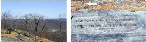
View from Long Mountain and Torrey Memorial. 2001 [TODD SCHREIBMAN]
0.80 The Long Path continues past the Torrey Memorial and starts a gradual descent from Long Mountain. In another 500 feet, the trail turns left and descends through a series of long switchbacks.
1.25 The trail intersects an old woods road to the left and crosses Deep Hollow Brook (the crossing can be difficult after a heavy rain). It then turns right and continues on a path alongside the stream. Meet a second stream paralleling the trail on the left. Shortly thereafter, the trail turns left at an opening in the woods and crosses the stream on rocks. It then ascends and approaches a cleared swath along the West Point boundary. The trail follows the boundary line, with some detours to the left and back again, for about half a mile. The trail eventually leaves the boundary permanently and heads left to top out at a knoll with lots of blueberries.
2.30 Reach the summit of Howell Mountain. The trail briefly continues its gentle descent on a curve, slabbing a rise to the right. Then, it abruptly turns left and begins a steep plunge into Brooks Hollow. The Long Path traverses a flat terrace before another left turn over the edge completes the descent, this time with switchbacks.
2.70 Cross the outlet stream from Lake Massawippa in the middle of Brooks Hollow, a classic U-shaped post-glacial valley. Its broad, flat floor with several intermittent streambeds, curves upward on both sides at a rapidly increasing pitch. Once across the stream, the trail turns left and goes upstream for a short distance before continuing across the valley floor. It reaches the valley wall and the trail begins a steep ascent of Brooks Mountain, principally by two long switchbacks. The second switchback becomes gentler in grade as it merges with the southwest trending crest of Brooks Mountain. Once on the crest, the grade is gently uphill with views of the steeply plunging valley to the left.
3.35 The ridge ends suddenly at a rocky knob. The Long Path turns to descend steeply to the left at first and then curves to the right around the end of the ridge. It reaches and climbs out of the small valley to views of Lake Massawippa a few hundred feet downhill to the left. The trail next undulates up and down through laurel and then blueberry, the dominant understory plants.
3.85 Reach NY Route 293 near a stream. Cross the road at the end of the guardrail, re-enter the woods, and start ascending.
4.05 The trail crosses a power line. The trail now ascends, often steeply, up the shoulder of Blackcap Mountain. Once attained, it follows the ridge crest southwest, closely paralleling the West Point boundary, until the trail descends toward Route 6.
4.55 Reach the southern trailhead of the seasonal Long Path. The seasonal Long Path on West Point property is closed May 1 through August 15 and during fall hunting season, and it is marked with aqua/white blazes. Please stay on the marked trail to avoid active military training exercises. If following the seasonal route, see turn-by-turn details at the end of this section description.
4.75 The trail crosses another power line, a small stream, and a stand of mountain laurel.
5.30 The trail approaches US Route 6 and turns west along the highway. The next blazes are about 30 feet inside the woods bordering the road, next to a chain-link fence.
5.60 Just before a small stream the trail turns left, leaves the woods, and turns right to cross a road (OP Charlie Road) near a West Point entrance gate. Continue through the wide grassy berme along Route 6. The trail veers to the right and crosses a clearing on a diagonal to the northwest. At the opposite side of the clearing, there is a telephone pole at the end of an abandoned paved road (the old Route 6).
5.85 Continue along the abandoned paved road.
6.45 Reach a barricade across the road with a small vehicle turnaround just beyond, on the right. The trail continues straight ahead on what is now known as Estrada Road, a quiet residential street, past several houses. Thomas Estrada-Palma, the first president of Cuba (1902-06), lived here from 1879 to 1902 while he headed a junta that financed the Cuban Revolution.
7.40 Continue straight, staying on Estrada Road. In 200 feet, in sight of the New York State Thruway, turn right onto Abrams Road. Pass Stone Gate Road on the right.
8.20 At a T-intersection, go right on Smith Clove Road (Orange County Route 9) and head away from the Thruway.
8.70 Pass a golf course entrance on right.
8.80 Turn left on Pine Hill Road. On the south side of Smith Clove Road opposite Pine Hill Road is the northern trailhead of the seasonal Long Path. Look for the aqua/white blazes between the golf course parking lot and The Gatehouse historic building.
9.40 Cross the Thruway and follow Pine Hill Road downhill as it curves.
9.70 Follow Pine Hill Road under the railroad.
9.80 Just before Pine Hill Road crosses Woodbury Creek, the Long Path turns right on a gravel road and gas-pipeline right-of-way, which runs between the railroad tracks and Woodbury Creek.
10.70 Cross a seasonal stream.
11.30 Pass underneath a railroad trestle (formerly the Graham Line of the Erie Railroad, now the Metro-North Port Jervis Line), go down the embankment, and cross Woodbury Creek. Note there is no formal crossing here and the water can be deep and fast, so prepare accordingly. After crossing the creek, turn right and climb to Route 32, which it crosses (use caution, as Route 32 is a very busy highway).
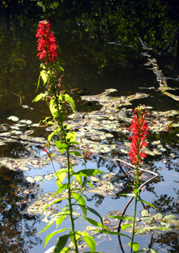
Cardinal flowers along the Woodbury Creek. 2010 [JAKOB FRANKE]
11.35 Section 7 ends about 100 ft north of the trestle, where the Long Path reaches a driveway and immediately turns left to climb an embankment. Note that the Highlands Trail (teal diamond blazes) joins the Long Path here after following Route 32 from the north, coaligning with the Long Path into Section 8.
Seasonal Long Path
4.55 Reach the southern trailhead of the seasonal Long Path. The seasonal Long Path on West Point property is closed May 1 through August 15 and during fall hunting season, and it is marked with aqua/white blazes. Please stay on the marked trail to avoid active military training exercises. If the seasonal route is closed, see turn-by-turn details above.
5.40 Cross OP Charlie Road.
6.75 Cross Proctoria Road, and descend on a series of switchbacks.
7.10 Cross Proctoria Road a second time.
7.60 Cross the outlet stream of Frederick Lake.
8.20 Reach the northern trailhead of the seasonal Long Path between a golf course parking lot and The Gatehouse historic building. Continue straight onto Pine Hill Road.
8.80 Cross the Thruway and follow Pine Hill Road downhill as it curves.
9.10 Follow Pine Hill Road under the railroad.
9.20 Just before Pine Hill Road crosses Woodbury Creek, the Long Path turns right on a gravel road and gas-pipeline right-of-way, which runs between the railroad tracks and Woodbury Creek.
10.10 Cross a seasonal stream.
10.70 Pass underneath a railroad trestle (formerly the Graham Line of the Erie Railroad, now the Metro-North Port Jervis Line), go down the embankment, and cross Woodbury Creek. Note there is no formal crossing here and the water can be deep and fast, so prepare accordingly. After crossing the creek, turn right and climb to Route 32, which it crosses (use caution, as Route 32 is a very busy highway).
10.75 Section 7 ends about 100 ft north of the trestle, where the Long Path reaches a driveway and immediately turns left to climb an embankment.
Previous Section: Section 6
Next Section: Section 8
8. NY Route 32 (Town of Woodbury) to Heritage Trail in Monroe
Section 8: NY Route 32 (Town of Woodbury) to Heritage Trail in Monroe
Quick Facts
Distance: 8.85 miles
Parks: Schunemunk State Park, Gonzaga Park, Heritage Trail
Maps: Interactive Map, West Hudson Trails (map 114)
Print-Friendly Version: Link
General Description
The Highlands Trail is co-aligned with the Long Path for the entirety of this section. The Long Path proceeds for a short distance just inside the woods on the south side of the right-of-way of the Metro-North Port Jervis Line, before beginning a steep ascent of Schunemunk Mountain. Schunemunk (pronounced "skun-uh-munk") is a northeast-southwest trending ridge, with steep sides and a nearly level top. The mountain was formerly owned by the Star Expansion Company. In 1996, the Open Space Institute acquired 2,100 acres of land on the mountain (including most of its ridgetop), and it transferred this parcel to the State of New York in 2003, securing its lasting protection and ensuring public access for future generations. Schunemunk State Park was New York's 163rd state park. Upon reaching the Jessup Trail, the Long Path turns south, and while the height of the ridge becomes lower, it still affords many fine views. The trail soon enters private lands. Hunting is allowed on these lands (as well as on the northern portion of Schunemunk Mountain); hikers should be aware of the dates of the various hunting seasons and plan accordingly. At the southwest end of the mountain, the trail enters Gonzaga Park and the continues toward the Heritage Trail in the Town of Monroe. The trail follows a mix of local roads and footpaths through privately-owned woods and pass along Orange-Rockland Lake. This section ends in a commuter parking lot adjacent to NY Route 17 (future Interstate 86).
Access
Take the New York State Thruway north to Exit 16, Harriman. Continue north on NY Route 32. Approximately 1.8 miles north of the "Woodbury Police" sign in the Village of Highland Mills, you will pass under a high railroad trestle painted black. The Long Path leaves the west side of the road about 100 feet north of the trestle.
Parking
0.00 At the intersection of Evans Drive and NY Route 32, about 0.2 mile south of the railroad trestle. (41.36085°, -74.10769°)
6.55 In Gonzaga Park, about 1.0 mile from Exit 130 of Route 17. (41.35669°, -74.17556°)
8.80 Monroe commuter parking area at Exit 129 of Route 17. (41.34678°, -74.19807°)
Trail Description
0.00 The Long Path crosses NY Route 32 across from a driveway, about 100 feet north of the high railroad trestle that goes over the road. Note that the Highlands Trail (teal diamond blazes) joins the Long Path here after following Route 32 from the north; the Highlands Trail heads northeast to Storm King Mountain, and southwest through Sterling Forest State Park to eventually reach the Delaware River in Riegelsville, NJ. The trail climbs a wooded embankment on rock steps, crosses under a railroad trestle on a gravel road and turns right to climb rock steps and a steep embankment (watch for poison ivy) to the grade of the tracks. The trail continues between a fence and an earth embankment for about 300 ft. At the end of the fence the trail crosses the earth berm, then makes a quick right and follows the bottom of the berm. After a short distance the trail climbs up onto the berm which runs along the railroad. The Long Path/Highlands Trail soon drops off the berm, goes up and down a bit, then turns away from the railroad.
0.45 The trail reaches a woods road and turns left. Almost immediately, just before reaching a gully, the trail turns right into the woods, soon reaching another woods road. Follow this second road to the right as it begins a meandering ascent of Schunemunk Mountain, crossing several stone walls along the way.
0.85 The trail turns left onto a narrow track and heads uphill. It now ascends steadily, first steeply, then more gradually, passing several good viewpoints, including one at Little Knob.
1.70 Reach High Knob. This open ridgetop has fine views up and down the valley and of the Hudson River to the north. The trail continues on the top of this flat ridge and then goes left on rocks forming the west side of the ridge. It descends to approach the head of the valley between High Knob and the main ridge to the west. As the gap between the ridges closes, the trail drops into the woods to cross two small rocky ravines before ascending a boulder-strewn slope to the opposite ridge. On the low ridge between the two ravines an unmarked trail goes right, and shortly afterwards, another unmarked trail goes left.
2.30 The Long Path/Highlands Trail crosses the old Woodbury Park trail. Traces of red blazes are still visible.
2.70 The trail crosses Dark Hollow Brook and climbs to the main ridge of Schunemunk Mountain.
2.90 The Long Path/Highlands Trail reaches the Jessup Trail (yellow) near the top of the ridge and turns left (south). The orange-blazed trail straight ahead is the Western Ridge Trail, the former route of the Long Path.
View from the co-aligned Long Path/Highlands Trail on Schunemunk. 2012 [JAKOB FRANKE]
3.35 An unmarked side trail on the right leads to a woods road that descends to Mountain Lodge Road in about 0.6 mile. Many other unmarked trails intersect the trail in the next three miles.
3.55 The trail passes an antenna park and leaves Schunemunk State Park. After bearing left at a fork, the trail curves to the left and heads towards the eastern side of the ridge. It emerges onto an open rock ledge, with views to the east.
4.40 The trail turns sharply right and soon crosses a small stream.
4.50 The trail climbs to the crest of the western side of the ridge and reaches a panoramic west-facing viewpoint.
4.60 The trail reaches another west-facing viewpoint and bears left, reentering the woods.
4.80 Pass a limited east-facing viewpoint and then a broader west-facing viewpoint.
5.05 The trail climbs to another panoramic west-facing viewpoint. It then descends steeply to a col and climbs rock ledges. For the next mile, the trail follows undulating terrain, with a number of ups and downs.
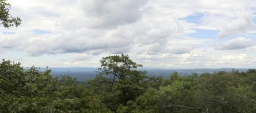
6.05 The trail emerges on a rock ledge, with panoramic views on both sides of the ridge – both to the east and to the west. The Shawangunks and the Catskills are visible to the northwest. From this viewpoint – the last one along the ridge – the trail descends steadily on a woods road.
6.40 Bear right at a fork, leaving the main woods road and continuing to descend on a narrower road.
6.55 Reach paved Seven Springs Road, which is closed to vehicular traffic. The Long Path/Highlands Trail continues across Seven Springs Road (a yellow-blazed spur turns right onto the road and ends in 0.1 mile at a gate, with the parking lot of Gonzaga Park* on the right). The trail descends slightly, crosses a small drainage area, and passes by a spring house. Shortly thereafter there is a small cemetery on the right. The trail soon reaches an old woods road which it follows to the right for a few hundred feet to an AT&T powerline cable right-of-way. The trail turns left here, crosses a couple of stone walls, and reaches Seven Springs Mountain Road (Orange County Route 44) and the entrance of Gonzaga Park.
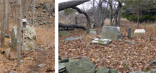
Spring house and Davison Cemetery in Gonzaga Park. 2014 [JAKOB FRANKE]
6.80 Cross County Route 44 and continue on Seven Springs Road.
7.25 Turn right into the woods, passing several stone walls and interesting low rock ledges. Near NY Route 208 there are foundations of an old homestead.
8.00 Cross Route 208 and enter the woods near Orange-Rockland Lake.
8.20 Reach the lake and follow its shoreline.
8.40 Reach Museum Village Road, turn left, and follow the road, crossing Route 17/Interstate 86.
8.75 Turn left onto Orange and Rockland Road and then turn right into a commuter parking lot.
8.85 Once in the parking lot, make a U-turn to find the Heritage Trail, a paved rail-trail. This is the end of Long Path Section 8.
Previous Section: Section 7
Next Section: Section 9
* Gonzaga Park is a 216-acre former Jesuit retreat that was acquired by Orange County in 2001 and has since been developed as a county park. The park is located in the towns of Blooming Grove, Monroe, and Woodbury, and there still are a few of the original buildings on the site, including a chapel.