3. Nyack to Long Clove
Section 3: Nyack to Long Clove
Quick Facts
Distance: 8.85 miles
Parks: Mountainview Nature Park, Nyack Beach State Park, Hook Mountain State Park, Rockland Lake State Park
Maps: Interactive Map, Hudson Palisades Trails (maps 110 and 111)
Print-Friendly Version: Link
General Description
The first two miles of this section are suburban and the trail frequently runs along roads or near houses. After leaving US Route 9W, the Long Path ascends Hook Mountain. Its bare summit affords splendid views up and down the Hudson River. The trail then continues through woodlands and along ridges, passing an old cemetery and old quarries.
Access
Take the New York State Thruway to Exit 11, Mountainview Avenue.
By public transportation: The Red and Tan Lines buses 9W and 9A give access to many points along the trail from US Route 9W.
Parking
0.00 Strip shopping centers along NY Route 59 may provide parking. (Unlocated)
2.10 Christian Herald Road at US Route 9W. (41.11008°, -73.92744°)
5.75 Landing Road (limited, tends to fill up on weekends). (41.14358°, -73.91232°)
6.35 Golf course parking lot (fee in season).
8.85 Southeast side of US Route 9W, across from Landmark Drive, formerly known as Long Clove Road (limited parking). (41.17449°, -73.94458°)
Trail Description
0.00 The section begins where Waldron Avenue/Mountainview Avenue crosses NY Route 59. There is a traffic light at the intersection. The Long Path continues north on Mountainview Avenue and heads uphill to the bridge over the New York State Thruway. This is a busy commercial area with food and phones widely available. Once across the Thruway, Mountainview Avenue passes a driveway on the right.
0.25 The trail turns right into woodland after passing the driveway. Next, the trail crosses a road from an apartment complex and ascends the steep pitch on the other side. It quickly bears right and passes through a narrow strip of woods with housing complexes on both sides. At the next junction, continuing eastward on a woods road leads to a corner of Oak Hill Cemetery where there are spectacular views of the Tappan Zee, one of the widest parts of the Hudson. The trail turns left instead and climbs the woods road on a series of switchbacks to a water tank.
0.70 Now on the level, the trail continues northward along a stone wall. It skirts another garden apartment complex on the left through adjoining woodland. An unmarked trail drops down on the right to the Nyack High School, but continue on the level. Finally, the trail turns downhill on an old driveway and reaches Christian Herald Road.
1.70 Turn right onto Christian Herald Road.
2.10 The Long Path turns left onto US Route 9W at a traffic light.
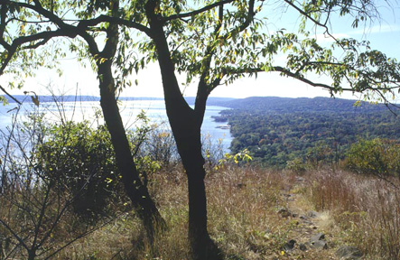
View from Hook Mountain [MICHAEL WARREN]
2.50 Leave US Route 9W through a gap in the guardrail. After about 20 feet, the trail turns right into the woods and moves diagonally away from the road. In another 250 feet, reach the southern junction of the Boulders Loop Trail (white), which leaves downhill. The trails are co-aligned for 0.1 mile before the Boulders Loop Trail leaves to the right, descending downhill through the woods toward Nyack Beach State Park (the complete Boulders Loop Trail is 2.8 miles). This Boulders Loop Trail also allows for a circular hike using the Long Path and River Trail at the base of Hook Mountain. Continuing uphill, views of the Hudson River and the Tappan Zee Bridge appear, and the trail begins the often steep and rocky climb up Hook Mountain.
3.25 The open, rocky summit of Hook Mountain affords a tremendous view up and down the Hudson River with the Palisades visible to the south on the right bank of the river. The trail now descends through dry woods. Many fine views occur as the trail trends downward along a broad woods road on the west side of Hook Mountain's ridge. As the trail approaches the recreation areas of Rockland Lake State Park, it passes an old stone wall and several unmarked trails leave on both sides. After a final steep descent, reach Landing Road. Turning right, Landing Road will meet the Shore Path. It can be used for a circular hike over and around Hook Mountain. Turning left leads to Rockland Lake State Park and US Route 9W.
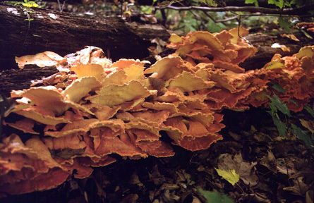
Chicken mushroom (Laetiporus sulphureus) [JAKOB FRANKE]
5.75 The Long Path crosses Landing Road and begins to climb. It quickly passes a tiny, old cemetery, the Wells Family Cemetery, with faded headstones from the 19th century. After passing the cemetery, the trail begins to go up and down, following the crest of the ridge. There are several beautiful views, some from precipices, of Croton Point Park on the other side of the Hudson River. The trail passes tennis courts and a stone wall to the left.
6.35 An unmarked trail leads left to the parking lot of the State Park golf course. When open, the concession provides water, phone and food. The Long Path continues along the ridge, often changing from upward to downward, with views through the trees both to the left and to the right.
8.45 The Long Path reaches the Treason Trail (white) on the right. This trail leads down to the Shore Path. The Long Path veers left, crosses under a power line beneath which there is a railroad tunnel, and descends to US Route 9W.
8.85 The trail reaches Route 9W just east of its intersection with NY Route 304. To continue, cross Route 9W and follow Landmark Drive, an abandoned town road formerly known as Long Clove Road.