Capital District
These northern sections of the Long Path slope down from the edge of the Catskills into the Mohawk River Valley. The hills of the western sections give way to gentle rises and falls shaped by glaciers and water punctuated by sharp cliffs of escarpments formed by tilted rock layers. Most of the lands have been settled for a long time and have remained productive farm or forest. Much of the trail passes through nature that has been coerced by civilization to behave in certain ways, either by being farmed for generations, or used as a managed forest for the supply of lumber.
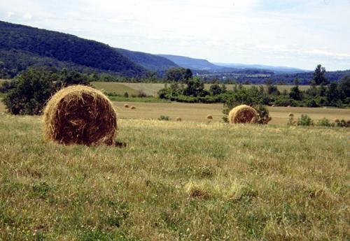
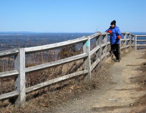
Field near East Berne. 2001 [ED WALSH]
32. Middleburgh to Lawton Hollow Road
Section 32: Middleburgh to Lawton Hollow Road
Quick Facts
Distance: 10.6 miles
Parks: Cotton Hill State Forest, Dutch Settlement State Forest
Maps: Interactive Map
Print-Friendly Version: Link
General Description
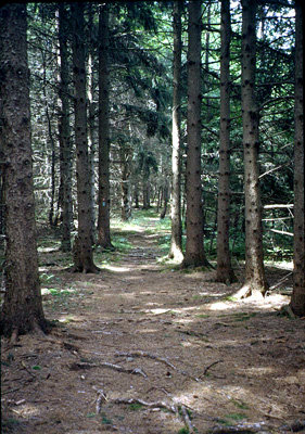
After leaving Middleburgh, the Long Path ascends the Cliffs. The trail route follows the edge of the cliffs, where there are spectacular views across and down the Schoharie Valley. Caution is required at all viewpoints, as they drop right off. Beyond the cliffs, the trail crosses the head of “The Gorge” and traverses through Cotton Hill State Forest and Dutch Settlement State Forest. The hike through Cotton Hill is a pleasant variety of trail and old woods roads. The forest varies from hemlock to red and white pine. As you enter each section of the forest, a climb to a high point is required. The Cotton Hill sections revolve around the northeast corner of Schoharie County. The section ends spectacularly after the trail crosses Canady Hill, with great open views to the Catskills and Partridge Run and Cole Hill in Albany County. The eastern and western ends of this section follow private property, while the middle 5 miles are on state land.
Access
Take the New York State Thruway to Exit 21 (Catskill). Take NY Route 23 west about 8 miles to NY Route 145. Take NY Route 145 west about 30 miles to the Village of Middleburgh. The trail section begins at the intersection of Route 145 and Route 30 in the Village of Middleburgh.
Parking
0.00 Village of Middleburgh (town park; elementary school). (Unlocated)
0.35 Straub Lane, at end of MT Path cul-de-sac. (Unlocated)
4.75 Durfee Road, in shale pit. (42.62752°, -74.28854°)
6.10 Treadlemire Road, at snowplow turn-around. (42.62352°, -74.27377°)
8.10 Cotton Hill Road (on shoulder). (42.62127°, -74.24890°)
10.50 Canady Hill Road (on shoulder). (Unlocated)
Camping
4.40 - 5.80 Cotton Hill State Forest is entered at mile 3.95, at first the the state land is thin strip of land. At around mile 4.4 the state land widens out to allow legal camping. Camping is allowed in the Cotton Hill State Forest 150 feet away from the trail, water and road.
6.30 Cotton Hill Lean-to, 0.2 mi east of Treadlemire Road.
Camping is allowed in the Dutch Settlement State Forest 150 feet away from the trail, water and road.
Trail Description
0.00 The trail turns east on NY Route 145 on the sidewalks through the Village of Middleburgh.
0.35 Past the blinking traffic light, the trail turns left from Main Street onto Straub Lane. Follow Straub Lane (which becomes MT Path) past the Cliffside Senior Apartments complex and several new homes toward the base of the Cliffs and cul-de-sac, where there is room to park a couple of cars.
0.75 From the cul-de-sac, the trail departs to the right on a dirt road to a shale pit on the left. The trail leaves the dirt road to the left for a steep ascent above the shale pit and enters a recently logged area, crosses several logging roads and continues to climb. A lemon squeeze is encountered in the cliff to reach the top. (To avoid the squeeze, continue on the dirt road which swings around the cliffs and reconnects to the trail at the top.) Just below the lemon squeeze is an eastern cedar tree that has been dated to be about 500 years old, the oldest cedar in New York and maybe the whole Northeast.
1.10 Once at the top, the best views of the village, Vroman’s Nose and Vromansland are captured. Continue north along the cliffs on an all-purpose trail.
1.40 A four-way intersection is reached. The woods road to the right leads back down to the cul-de-sac via "The Gorge," making for a short loop hike. The LP follows on the level to the left and continues along the cliffs edge.
1.65 There are spectacular views across the Schoharie Valley all along the escarpment. The forest is mixed with hemlock, red and white pine, and some hardwoods.
2.05 The trail intersects a series of logging roads and turns right to “The Gorge” side on property owned by the Trail Conference.
2.15 At an oak tree with a carved arrow, the trail turns onto another woods road to the left and ascends.
2.40 The trail levels to reach a "T" intersection with an old snowmobile trail. Turn left and ascend the ridge. As it rises to the 1700 foot high point, the trail crosses an old logging road and connects with the main all-purpose ridge trail.
2.80 After some level ridge walking, the trail descends slightly passing an old flagstone quarry. Pass a logging road to the right and then one to the left.
3.15 The LP turns right and leaves the ridge trail to descend to the head of "The Gorge." There is a quick right-left jog as the trail crosses an older woods road and continues to descend along a spring on the left and a recent logged area on the right.
3.50 The trail crosses three streams. Between the streams are views north through an open field.
3.75 Cross the third stream and ascend to the Cotton Hill State Forest through a logged area.
3.95 Reaching the state forest boundary corner, the trail turns left to follow a narrow strip of state land. On the left is an old “stump fence” that was constructed when the land was cleared many years ago.
4.30 Cross under power lines with a view left toward an old farmstead. The trail continues north through hemlocks.
4.75 The trail crosses Durfee Road. A shale pit parking area is to the right. Continue uphill through a red and white pine forest on the right and hardwoods on the left.
4.90 At the top of the hill, the trail bears right, connects with a woods road, and soon descends.
5.00 The trail “Ts” into another woods road and turns left. On the right is an old well that was built to be used by forest firefighters in the 1930's to fill their “Indian Fire Pumps” that they would carry on their backs. If the fire got out of control, the firefighters could seek refuge in the well.
5.10 The trail “Ts” into another woods road and turns right and descends to yet another “T”. Turn left and follow the road between stonewalls, passing a snowmobile trail to the right, to the state forest boundary and private property.
5.40 The trail turns right leaving the woods road and descends to a gorge. At the gorge edge, the trail bears left and follows the gorge through hemlocks ascending to Treadlemire Road.
5.80 Turn left and follow Treadlemire Road uphill passing several houses.
6.10 On the right is a small parking area and snowplow turn-around where the trail exits the back and enters the Dutch Settlement State Forest on a woods road. In 300 feet, the LP turns left from the road to wind through a narrow crevice in a rock out-crop which resembles elephant skin. Linking back to the logging road, the trail turns left and ascends steeply.
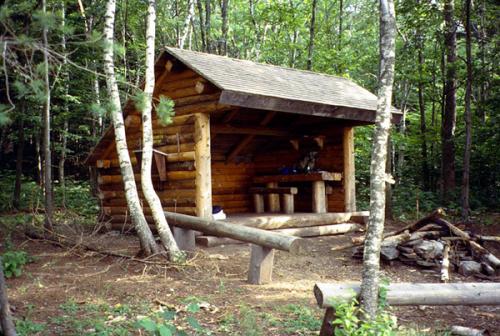
Cotton Hill lean-to. 2001 [ED WALSH]
6.30 The trail turns left from the logging road and follows a north-western escarpment to a lean-to with views to northern Schoharie County.
6.40 Cross Cotton Hill (a.k.a. Babcock 2) with an elevation of 2114 feet. To the left, about 52 paces, are the USGS survey monument and a radio/communications tower.
6.95 Descend along the north border of state land and turn left crossing a stone wall at the corner boundary. Soon the trail bears right, descends slightly, and then levels again.
7.40 Reach a woods road, turn right and emerge at an old farmstead clearing and a DEC access road. This road is the boundary between state land on the left and private land on the right.
7.80 A snowmobile trail comes in on the left. Continue straight and pass another firefighter well on the left; the road bears to the right to reach Cotton Hill Road.
8.10 Cross Cotton Hill Road and descend to the right and cross a foot bridge over a tributary of Fox Creek. Follow the stream down for a short distance and then climb the bank to reach an old woods road. Ascend to the right along this road through a white and red pine forest.
8.55 The trail leaves the road, turning right and climbing steeply. (Watch close for a big turn arrow.) At the top of the hill, the trail continues south along Cotton Hill’s eastern boundary. The trail soon begins to descend.
8.90 Before reaching another boundary corner, the trail crosses a DEC access road that leads out to Brooky Hollow Road. At the corner, the trail turns left and stays on the state land.
9.10 The Long Path bears right and descends along the state forest boundary. While descending the trail enters private land. Camping, fires, etc. are prohibited beyond this point.
9.30 Turn left. The trail crosses a small stream and levels out.
9.40 Cross another small stream and ascend steeply through the woods to a woods road, which is 100 feet below the top of Canady Hill. Turn right and follow this road.
9.90 The trail turns left off the woods road and climbs over the hill.
9.95 Continue downhill following the right side of a hedgerow, then crossing the hedgerow to reach a grassy field drive which leads out to Canady Hill Road.
10.30 This area is very wet during the spring, but unavoidable.
10.50 The Long Path turns right onto Canady Hill Road.
10.60 This section ends at the intersection of Canady Hill and Lawton Hollow Roads. Note that the next section continues south on Canady Hill Road except during hunting season, when a section of Long Path through private property is closed and a roadwalk detour starting on Lawton Hollow Road is necessary.
Previous Section: Section 31
Next Section: Section 33
33. Lawton Hollow Road to Switz Kill
Section 33: Lawton Hollow Road to Switz Kill
Alerts
- The description has been updated with a major relocation through the Partridge Run area that was established in summer 2023.
Quick Facts
Distance: 12.45 miles
Parks: Partridge Run Wildlife Management Area
Maps: Interactive Map
Print-Friendly Version: Link
General Description
Section 33 of the Long Path mostly follows a mix of old ski trails and snowmobile trails and newer footpaths through both Partridge Run Wildlife Management Area and Partridge Run State Forest. The walking is not difficult and there is little elevation gain, just small ups and downs. The exceptions are at the beginning and end of the section, where the Long Path must climb up to the plateau of Partridge Run. The first 0.3 miles and the last 0.2 miles are on paved roads. Some of the park trails are also accessible by vehicle, but are little used. The trail passes through many reforestation areas, primarily of Norway spruce and red pine. There are also several ponds and lakes along the way. Views are limited, but more numerous when the leaves are down. Because skiers and snowmobilers share the trails in the winter, there are a number of wet areas, particularly in the beginning of the section.
Access
Take the New York State Thruway to Exit 22 in Selkirk. Turn right on NY Route 144 and go south to NY Route 396. Turn right on Route 396 and follow it 6 miles to South Bethlehem, where Route 396 ends. The road becomes Albany County Route 301 here. Follow Route 301 west another 6 miles to its terminus at NY Route 443 in Clarksville. Turn left on Route 443 and follow it 11 miles to the village of Berne. Continue on Route 443 another 3 miles to West Berne. In West Berne, turn left on Albany County Route 9. Follow Route 9 for about a mile until it makes a sharp left. Continue straight ahead on Bradt Hollow Road. Follow Bradt Hollow Road for about 3 miles, where it intersects Lawton Hollow Road. Turn right on Lawton Hollow Road and follow it for 1.55 miles to the intersection of of Canady Hill Road.
Parking
0.30 East shoulder of Canady Hill Road. (Unlocated)
2.30 Off Bradt Hollow Road. (42.58265°, -74.20622°)
6.15 Tubbs Pond. (42.56730°, -74.18128°)
6.90 Fawn Lake. (42.56185°, -74.16544°)
7.90 Partridge Run Road and Ravine Road (Albany County Route 6). (42.56118°, -74.15094°)
8.40 End of Partridge Run Road. (Unlocated)
9.50 Shale Forest Road. (Unlocated)
12.45 Switz Kill Road and Gifford Hollow Road. (42.57715°, -74.11854°)
Camping
Camping is allowed in Partridge Run, but only in the reforestation areas, not in the Wildlife Management Areas, and 150 feet away from the trail or water source. There is a lean-to 150 yards straight ahead at the right turn to reach Gifford Hollow Road (12.05 mi).
Trail Description
0.00 This section starts at the intersection of Canady Hill and Lawton Hollow Roads, continuing south on Canady Hill Road. Note that during hunting season, the regular route of the Long Path described here is closed and a roadwalk detour starting on Lawton Hollow Road is necessary. This roadwalk detour is described at the bottom of this section description.
0.30 Turn left and enter the woods on private land, just prior to reaching a house on the right and the intersection of Bassler Road. The trail follows a stone wall for some distance.
0.50 The trail leaves the woods road, crosses a small drainage and then starts uphill through the woods.
0.85 Near the top of the hill the trail intersects a snowmobile trail and follows it for a short distance. The trail leaves the snowmobile trail and starts downhill.
1.40 Cross a small drainage, turn left on an old road for a short distance, then turn right heading uphill.
2.10 Reach the top of the hill and turn right.
2.30 The Long Path enters the Partridge Run Wildlife Management Area, with the boundary marked in yellow paint. The trail continues straight on the Nordic ski trail, bordering an area that was clear-cut several years ago. Reach an intersecting trail and bear right. In a short distance another ski trail connects from the right. The Long Path leaves the ski trail on the left through a brushy area and into fairly open woods following stone walls and logging roads. The trail emerges back on the ski trail at the iron gate on High Point Road.
2.85 Reach High Point Road at a gate, and turn left (east) and uphill. Soon pass a small parking area on the right.
2.95 Turn right off the road into the woods shortly after the parking area. The trail meanders through second growth red pines, then turns left to cross the remnants of a stone wall. After crossing the wall, the trail turns right at the border of a mature red pine plantation with open woods.
3.15 Reach an old logging road and turn left (south). Descend to cross a seasonal stream that is rarely more than a couple inches deep, then reach a large, first growth pine and turn left up a small hill. The trail parallels the side of the hill for a short distance and then descends through open woods and down to the left of a stone wall that parallels the logging road.
3.30 At the end of the stone wall, reach the Bradt Hill Ski Trail and turn left, heading uphill. In about 0.1 mile, turn right into the woods for a short distance to avoid a wet area before rejoining the ski trail.
3.45 Turn left off the Bradt Hill Ski Trail, staying uphill near the edge of a large red pine plantation with some remarkably large trees and attractive, open woods. Turn right where the trail approaches two very large pines and a logging road.
3.55 Reach junction with white-blazed spur trail that proceeds 0.05 mile to a parking area across Bradt Hill Road. Turn right and cross remnants of a stone wall, then turn left past some very large pines.
3.60 Reach Bradt Hill Road and turn right to follow along the road, soon passing the gate for the end of the Bradt Hill Ski Trail on the right.
3.65 Turn left off the road into the woods, cross the remnants of a stone wall, and turn left to wind through large white and red pine.
3.75 Reach a gap in the stone wall and turn right. The trail parallels the wall for a short distance before heading into more second growth red pine, some of which are very large.
4.00 Reach the Blue Ski Trail, a logging road, and turn right. This area is marked for logging, so there may be limited blazes over the next 0.1 mile. This trail will remain intact and safe through the logging activity, which is anticipated in winter 2024.
4.10 Reach the Yellow Ski Trail and turn left, following a small "Trail" sign and a sign for Beaver Road. Note that from this junction to mile 5.65, the Long Path is in Partridge Run State Forest instead of the Wildlife Management Area. The Yellow Ski Trail, which occasionally includes blue markers as well, proceeds along a winding logging road through large, red pine trees. The trail parallels a stone wall on two sides of an old field and then heads downhill, then turns right at a junction where an unmarked logging road continues straight.
4.50 Turn right at a junction with an unmarked logging road, then quickly turn left up into the woods after a large balsam tree within view of the trail junction. The trail angles away from the Yellow Ski Trail and soon bears left.
4.70 Reach a gap in a stone wall and turn right, paralleling the stone wall with a line of large maples.
4.85 Turn left and downhill away from the stone wall, around a very large pine, then proceeds to the right through an open area and more woods.
4.95 Cross an intersection with a logging road/horse trail that was also the former Long Path route prior to this 2023 relocation. The trail winds through large pines, across a seasonal stream with stepping stones, and past a number of large, old trees. It eventually crosses another seasonal seep and stream and proceeds around a plateau and uphill to follow a stone wall below pine plantation marked for eventual cutting activity. The trail soon heads downhill and makes a sharp left turn approaching Beaver Road.
5.65 Cross a junction with the old Horse Trail near its junction with gravel Beaver Road, and proceed straight to reach the road. Turn left (north) to follow Beaver Road.
5.85 Turn right off the road and follow a snowmobile trail downhill through a mature stand of spruce and pine.
6.15 Reach Tubbs Pond, turn right, cross the outlet of the pond to the right on a foot bridge, and reach the Tubbs Pond parking area. The trail follows the cinder Tubbs Pond access road.
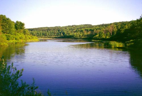
Tubbs Pond. 2001 [ED WALSH]
6.55 Reach intersection with Fawn Lake Road, turn right and follow it as it parallels Fawn Lake on the right.
6.90 Reach the end of the road and Fawn Lake parking. The trail turns left on a woods road and descends along a gorge following Fawn Lake’s outlet stream. To the left are the remnants of a 1930s deer management area.
7.35 Reach a trail intersection. The trail to the left leads to White Birch Pond. The Long Path turns right, crosses a stream on a bridge, and heads east toward White Birch Pond Road.
7.60 Reach White Birch Pond Road and turn right.
7.80 The trail jogs left on Ravine Road (Albany County Route 6), then right on Partridge Run Road. There is room to park several cars.
8.10 A path leads right about 100 feet to a waterfall along the stream.
8.35 Partridge Run Road bears right and crosses the stream. The Long Path bears left away from the stream, reaches a parking and picnic area at the end of the road, then continues straight ahead through a gate on a gravel road. The trail passes a small pond on the right.
8.75 Intersect a snowmobile trail that goes left. Continue right on the gravel road, intersecting another trail in 500 feet. The trail left leads to Wood Duck Pond. The Long Path bears right.
9.15 Reach a shale road (Kingfisher Road), and turn right.
9.50 Turn left, reach a parking area and continue on a snowmobile trail.
9.70 Reach the crest of the hill and turn right to descend. There are views of the Blackhead Range here when the leaves are down. The trail swings left to reach the eastern escarpment, then left again to follow it.
10.05 Following Partridge Run’s eastern escarpment north, there is a view across Gifford Hollow to Cole Hill.
10.35 The trail bears left, switchbacks uphill beneath a rock ledge, then continues north on the escarpment.
10.60 Reach an old woods road and turn right.
10.90 The trail turns right on another woods road and descends down to a level area before climbing again.
11.10 Reach the bottom of the hill, turn right and enter a hemlock grove, gently climbing again.
11.25 Turn left on another faint woods road, leave Partridge Run and begin descending to the Switz Kill. The trail enters private property.
11.40 The trail turns right and descends through the woods. It emerges on an overgrown field and continues east, following a hedgerow. Watch for the blazes to be sure you are in the correct field. At the end of the first field, cross a stream in a hedgerow and follow the hedgerow across a second field.
12.05 The trail almost reaches the east edge of the field and turns right onto a field drive to reach Gifford Hollow Road. Straight ahead at the turn, about 150 yards, is a lean-to built by Adam Forti from Boy Scout Troop 79 as an eagle scout project in 2011-2012. The fire place at the lean to was built by Eagle Scout Joe Staubach from Troop 79. The campsite is maintained by Troop 79 and the landowner.

Lean-to at mile 12.05. 2012 [MARK TRAVER]
12.25 Reach Gifford Hollow Road and turn left.
12.45 Gifford Hollow Road intersects Switz Kill Road (Albany County Route 1), where this section ends. Turn right on Switz Kill Road to continue.
During hunting season, the beginning of the Long Path in this section is closed. Follow the roadwalk detour, which is 0.4 mile longer, as described below:
0.00 At the intersection of Canady Hill and Lawton Hollow Roads, turn left (east) on Lawton Hollow Road.
1.10 Reach a shale bank on the left, with room to park a couple of cars. This is the Albany County boundary line. The trail continues east on Lawton Hollow Road.
1.70 Turn right onto gravel Bradt Hollow Road and head uphill. In approximately 0.6 mile, the trail enters Partridge Run Wildlife Management Area.
2.45 Turn right off the road onto a woods road. There is room to park several cars here, but the parking area is accessible only during the dry season. Just beyond the parking area, follow a snowmobile trail over a knoll, then descend into the woods following the northern boundary of Partridge Run Wildlife Management Area.
2.70 Reach the regular route of the Long Path near the boundary of the WMA. Turn left (south) and follow the description from mile 2.30 above (be sure to add 0.4 mile to each mileage entry to account for the increased length of this roadwalk detour).
Previous Section: Section 32
Next Section: Section 34
34. Switz Kill to East Berne
Section 34: Switz Kill to East Berne
Alerts
- No current alerts.
Quick Facts
Distance: 9.2 miles
Parks: Cole Hill State Forest
Maps: Interactive Map
Print-Friendly Version: Link
General Description
This section of the Long Path is a pleasant blend of ski trails in the state forest, road walking and woodland trails. The Long Path leaves the valley of the Switz Kill and goes along Willsie Road to the top of Cole Hill, where it follows a series of recently constructed ski trails through a mature forest. There are views from Cole Hill, and the trail passes several beaver ponds that have the feeling of the Adirondacks. Past Cole Hill, the Long Path goes along public roads, with a view of the Catskills in the distance. Upon reaching the Doppler weather tower for the Albany region, the trail reenters the woods and begins a gradual descent through land that was once farmed. The Long Path passes through a field, crosses Joslyn School Road, and descends through a pine forest. It then crosses Fox Creek and finally emerges on NY Route 443.
Access
Take the New York State Thruway to Exit 22 (Selkirk). Turn right on NY Route 144, and continue south to NY Route 396. Turn right on Route 396 and follow it for 6 miles to South Bethlehem, where Route 396 ends and the road becomes Albany County Route 301. Continue on Route 301 west another 6 miles to its end at NY Route 443 in Clarksville. Turn left on Route 443 and follow it 11 miles to the village of Berne. About a mile west of Berne, turn left on Albany County Route 1 and follow it south about 4 miles to Gifford Hollow Road.
Parking
0.00 Switz Kill Road (Albany County Route 1) and Gifford Hollow Road. (42.57715°, -74.11854°)
3.10 Turnoff on right side of Irish Hill Road. (42.59720°, -74.11107°)
4.15 Willsie Road. (42.59349°, -74.10602°)
5.10 Cole Hill Road. (42.59456°, -74.09527°)
7.00 Woodstock Road at weather station. (42.58694°, -74.06354°)
9.20 Stage Road, near the intersection with NY Route 443, about 0.1 mile east of the trail. ( 42.60218°, -74.04600°)
Camping
2.75 Camping is allowed in Cole Hill State Forest 150 feet away from the trail and from water.
Trail Description
0.00 The Long Path leaves the Switz Kill Valley at the intersection of Switz Kill Road and Gifford Hollow Road and begins to climb following Switz Kill Road.
0.65 Reach Willsie Road, turn left and head uphill, following paved Willsie Road. Near the top of the hill, there is a view back to Partridge Run and the Catskills.
2.10 The trail reaches the southern boundary of Cole Hill State Forest and enters the woods on the left across from a small parking area. It proceeds westward, descending to a small stream and crosses it on a bridge. Beyond the stream, the trail ascends, gradually swinging towards the northwest and then turning to the north at the top of the slope. It then enters a reforested area and passes through alternate fields of pine and spruce, each separated by mixed hardwoods and stone walls. After the fourth stone wall, the trail turns right (east) on a fire access road to join a cross country ski trail.
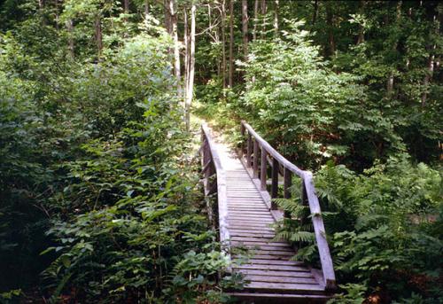
Bridge in Cole Hill State Forest. 2001 [ED WALSH]
3.10 The trail crosses Irish Hill Road. There is a parking area at the north side of this crossing. The trail is mostly marked in the standard aqua paint blazes, but there are also DEC ski trail markers and red trail markers.
3.25 The Long Path reaches a 2015 clear-cut area and turns left on an intersecting trail. After a short distance, it turns right, crosses a stone wall, and follows the top of an escarpment.
3.45 Reach an overlook over the escarpment, with views west over the Switz Kill Valley to Partridge Run. Just past the overlook, cross another stone wall and turn left on an old woods road.
3.75 Reach the boundary of the state forest, where the trail turns right. Remain within the forest, as a woods road to the left leads into private property.
4.05 Begin to descend. Turn left on yet another ski trail, then turn right and continue to descend to Willsie Road.
4.15 Cross Willsie Road and re-enter the woods. In another 500 feet, the trail turns left, and then turns right to begin a series of corduroy, stepping stones and a foot bridge.The trail begins a gradual ascent and turns left.
4.50 The Long Path passes through a deep forest known locally as the “Avenue of the Pines.” At the far end of this forest, there is an opening in the woods, with a view to an abandoned beaver pond. This old pond is now a wetland filled with marsh grass.
Avenue of the Pines. 2001 [ED WALSH]
4.70 Reach another beaver pond in a beautiful pine forest, a wonderful lunch spot. Here, the Long Path turns left and crosses a substantial bridge. The scene here is quite reminiscent of the Adirondacks. Beyond the beaver pond, the trail climbs steeply to a hemlock grove, briefly turns left on an old woods road, and then ascends to Cole Hill Road.
5.05 Turn right and continue uphill on paved Cole Hill Road. There is a parking area here. In the future, it is anticipated that the Long Path will be rerouted through the woods in this area, but for the present, it follows public roads for about 2 miles.
5.45 Reach the crest of Cole Hill Road, with views south toward the Blackhead Range and Windham High Peak in the Catskills. As you continue on Cole Hill Road, the view opens up to include Mt. Hayden, Mt. Pisgah, Richmond Mountain, Ashland Pinnacle and Huntersfield Mountain, the route of the Long Path as it heads northwest from the Catskills to Schoharie County.
5.90 Turn left on Woodstock Road, and pass Woodstock Lake Campground, a large private campground and RV park, to the right.
6.75 Reach intersection with Filkins Hill Road to the left, but continue straight on Woodstock Road.
6.95 As Woodstock Road turns right, the Long Path continues straight ahead on a gravel road that leads to a weather station.
7.10 Pass the National Weather Service's Albany Region Doppler radar tower on the right. This tower tracks and warns of severe storms. Vehicles may not be driven beyond this point. The Long Path descends from Stafford Hill on a narrow woods road, with a rock ledge on the left at the bottom of the hill.
7.40 Continue straight ahead on an older woods road, as the road that the Long Path has been following turns left. In 500 feet, bear right at a fork, and begin a gradual descent through dense foliage.
7.65 Reach an intersection, with a gravel road to the right, and a level ATV track to the extreme left. The Long Path crosses both roads and descends slightly to the left. If you are going in the opposite direction, continue straight ahead across the gravel roads. You will know that you are following the correct route if you pass between the “Posted” signs of two different landowners. After a slight descent, the trail bears right, following an old woods road.
7.80 The Long Path crosses a seasonal wet area on stepping-stones, and then turns left across level terrain. In 0.2 miles, the trail begins a gradual descent, and then intersects a stone wall that it follows downhill, descending more steeply.
8.40 Turn right along a row of pines above a stone wall and a logging road, parallel to the edge of a field.
8.60 Turn left to enter the field and head downhill to a hedgerow of mature trees parallel to Joslyn School Road. There are very nice views of the farm and a pond, as well as views across the road to Pinnacle Mountain.
8.70 At the northern end of the hedgerow, reach Joslyn School Road and turn left (north) to follow the road. In 100 feet, turn right to cross Joslyn School Road across from a driveway to a barn, then turn left to follow the field edge parallel to the road. At the edge of the field, turn right onto a farm road then quickly turn left into the woods in about 20 feet. The trail parallels Joslyn School Road for a short distance before turning right through large red pines.
8.90 Turn left at log steps and soon follow a field edge with nice views to the west over the field. Descend to cross a wide, planked bog bridge, then follow another field edge along the top of an old stone wall. Some of the stones in the wall can shift as you walk on them. The trail then turns away from the field.
9.10 Cross a snowmobile bridge over Fox Creek, then turn left along the edge of a field to climb toward NY Route 443.
9.20 Climb a short set of stairs to reach NY Route 443, where this section ends. Cross the road and then follow the edge of a driveway to continue on the next section.
Previous Section: Section 33
Next Section: Section 35
35. East Berne to John Boyd Thacher State Park
Section 35: East Berne to John Boyd Thacher State Park
Alerts
- The description has been updated with a relocation north of the John Boyd Thacher State Park Visitor Center that was established in summer 2023.
Quick Facts
Distance: 10.95 miles
Parks: John Boyd Thacher State Park
Maps: Interactive Map
Print-Friendly Version: Link
General Description
This section of the Long Path starts pleasantly as it passes through farm country. The section begins where the Long Path crosses NY Route 443 and follows a grassy road past a farm house to reach Stage Road. For the next mile the trail continues though fields and forests until it reaches Sawmill Road. The trail then continues along local roads to John Boyd Thacher State Park. The Long Path follows a series of trails through the park, emerging on the cliffs of the Helderberg Escarpment at the overlook on the north side of NY Route 157. Here, there are spectacular views northeast into Vermont. This ridge is made up of a core of limestone in which were found many fossils during the early days of geology in the 1800s. These fossils are known worldwide for their sequence from the Silurian to the Devonian eras. Early studies in this area helped lay the foundations for modern paleontology and geology. The Long Path then turns north and descends on the historic Indian Ladder Trail under the base of the cliffs, continues north through the park along the escarpment, and then heads in a generally northwest direction through the woods. The section ends at the north end of the park in the parking lot off Old Stage Road.
Access
Take the New York State Thruway to Exit 22 (Selkirk). Turn right on NY Route 144 and continue south to NY Route 396. Turn right on Route 396 and follow it 6 miles to South Bethlehem, where Route 396 ends and the road becomes Albany County Route 301. Follow Route 301 west another 6 miles to its end at NY Route 443 in Clarksville. Turn left on Route 443 and follow it west about 5 miles to the second intersection with Stage Road, 1.5 miles from the intersection of NY 443/85.
Parking
0.00 Stage Road, near the intersection with NY Route 443, about 0.1 mile east of the trail. (42.60218°, -74.04600°)
3.50 John Boyd Thacher State Park parking area on Beaver Dam Road. (42.63870°, -74.01524°)
4.55 Lower Paint Mine Picnic Area (about 0.2 miles off the trail). (42.65111°, -74.01632°)
5.20 Helderberg Escarpment Overlook parking area. (42.65248°, -74.01204°)
6.20 North end of Indian Ladder Trail. (42.65481°, -74.01787°)
10.95 Old Stage Road (limited). (42.68158°, -74.05442°)
Trail Description
0.00 The Long Path crosses NY Route 443 just east of the driveway of a private residence and heads uphill in a northeasterly direction along the edge of a large field. The trail climbs gradually and passes a farm house on the left when it reaches Stage Road.
0.15 Reach Stage Road and continue straight to follow the road through farm fields.
0.40 Turn left at a hedgerow bordering a field, crossing a short bridge over the drainage ditch. The trail descends gradually north along the west side of the hedgerow. There is an expansive view west, across open fields, toward Cole Hill and the Schoharie Valley.
0.80 Bear right through a gap in the hedgerow, then enter a young hardwood forest.
0.95 Reach Sawmill Road opposite its intersection with Stempel Road, and turn left (north) to follow Sawmill Road.
1.30 Turn right (east) onto Long Road.
2.35 Turn left at Elm Drive.
2.50 Bear right onto Bush Drive.
3.25 Turn right onto Beaver Dam Road (Albany County Route 303).
3.50 Turn left off the road into the woods at a trailhead for John Boyd Thacher State Park. Parking is available for several cars along a wide gravel shoulder. In about 200 feet, turn left (west), now following a coaligned blue-blazed trail.
3.90 Bear left as the blue-blazed trail turns right. Soon cross a small stream and pass a white connector trail.
4.10 A Nature Trail joins from the right at the head of a ravine. The Long Path and coaligned Nature Trail continue ahead, gradually descending on the left side of the ravine.
4.40 Turn right at a junction with a white connector trail. The white connector trail continues straight to reach the Lower Paint Mine picnic area and pavilion in 0.15 mile. The Long Path crosses the ravine on a bridge and follows the lower part of the Nature Trail. In 0.1 mile, the Natural Trail forks to the right, but bear left to remain on the Long Path and pass through a dense hemlock forest.
4.85 Turn left to follow a woods road that leads into the Upper Knowles Flat Picnic Area. The trail follows the north edge of the picnic area, then descends right on a gravel path to the paved access road. The trail then turns right onto the access road toward NY Route 157.
5.15 Cross NY Route 157 and reach the Overlook parking area. The trail turns left and follows the overlook along the edge of the escarpment, with spectacular views across the upper Hudson Valley to the Green Mountains of Vermont and the Adirondacks of New York.
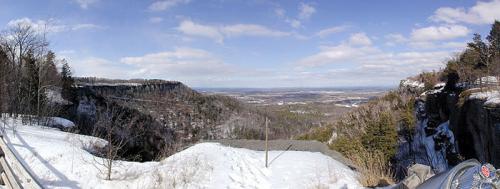
Panorama from Thacher Park lookout. 2001 [HERB CHONG]
5.40 Reach the northern end of the parking area, and continue to follow the escarpment fence through the woods. About about 0.2 mile, emerge from the woods to reach a view over Mine Lot Falls, which plunges over the escarpment, near La Grange Bush parking lot.
5.70 Reach the southern end of the Indian Ladder Trail, which descends stairs to the right. Note the Indian Ladder Trail is only open from mid-May to late fall, as it is dangerous when there is ice; the Long Path follows the Indian Ladder Trail when it is open, but follows the path along the top of the escarpment (which passes another overlook and the top of the falls) during the remainder of the year. When open, turn right onto the Indian Ladder Trail and descend a series of stairs. At the base of the stairs, follow the bottom of the escarpment northward under the cliffs, passing under Mine Lot Falls and another waterfall (the water flow for each is very variable, so they can be just a trickle during dry periods). The trail then reaches another set of stairs that climbs back up to the top of the escarpment.
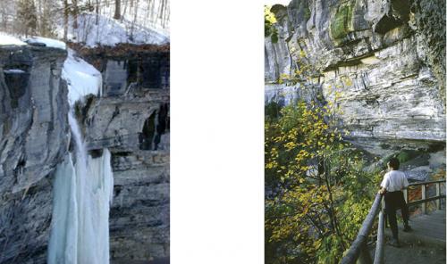
Mine Lot Falls in the winter. 2001 [HERB CHONG] Base of the Indian Ladder Trail. 2001 [MICHAEL WARREN]
6.20 Reach the northern end of the Indian Ladder Trail. To the left is the Visitor Center, which is worth a short detour. The Long Path turns right to follow the Escarpment Trail, which follows the escarpment fence and offers periodic views through the trees.
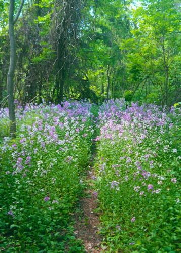
Wildflowers growing near the ranger station. 2001 [LOREN DOBERT]
6.50 Reach a viewpoint along the escarpment and picnic area near the Horseshoe 1 parking area. The trail continues following the escarpment as it loops around this horseshoe-shaped section.
6.80 To the left through the trees is the Horseshoe 2 parking area.
7.20 Reach another panoramic viewpoint over the escarpment near the northern end of the Hailes Cave parking lot. In a short distance, the trail passes a rock climbing area entrance called Squeeze Box and then turns left away from the escarpment, crosses Hailes Cave Road, and soon reaches a grassy road. Follow this road as it continues through an open area.
7.35 Turn right off the grassy road into the woods. This section of trail includes many narrow fissures, some very deep, that crisscross the woods. The trail parallels and then crosses a stone wall to reach an old woods road.
7.55 The trail turns right on the old road and enters the OSI Thacher Park Nature Preserve.
7.75 The Long Path turns left off the woods road to climb along a switchback to the top of the ridge and a junction with another woods road.
7.85 The trail meets a yellow-blazed woods road leads left in 0.3 miles to Ryan Road and a small parking area. The trail turns right and follows the crest of the ridge through a mixed forest of pine, hardwoods and low-growing juniper.
8.25 After reaching a cairn that marks the highest point on this trail section, about 1,410 feet, the Long Path descends gradually from the escarpment, staying near its edge.
View from the escarpment in John Boyd Thacher State Park. 2010 [JAKOB FRANKE]
8.65 The Long Path reaches a junction with another trail (blazed white) and turns right, descending steeply to a gravel road used by hang-glider enthusiasts to access a take-off pad at the edge of the escarpment. Turn left on the hang-glider road. (To reach the hang-glider launch site, continue straight ahead on the road at this point.)
8.85 The trail leaves the hang-glider road and bears right, circling a depression in the escarpment.
9.15 The trail crosses an old stone wall.
9.25 Reach the middle of an old juniper stand and turn right. The forest along the trail is laced with fascinating fissures caused by acidity eating away the escarpment’s limestone.
9.35 A red-blazed trail joins the Long Path from the left. Both Long Path and red blazes now mark the trail. It is important to remain on the trail in this area, to avoid potential injury from stumbling into a fissure.
9.75 The trail reaches a point where it turns sharply left, heading west. Just ahead and to the right is an open 'High Point' viewpoint. To the right Mt. Everett in southern Massachusetts is seen peeking over the shoulder of the hang-glider opening. Panning north you will see Albany, Mt. Greylock, the Town of Altamont, and Vermont’s Green Mountains with Killington and Pico Peak prominent.
9.95 The Long Path crosses a white-blazed woods road. The Long Path continues past a stone wall to the left onto a segment of an old woods road, then bears left away from the woods road through mixed deciduous and evergreen forest, winding through several stands of hemlock.
10.25 The Long Path turns right, leaving the red-blazed trail, and skirts fields and stone walls on the left.
10.45 The Long Path crosses a woods road leading to a field on the left and then skirts the edge of the field.
10.65 The trail crosses a field and then re-enters the woods, passing through many stands of hawthorne bushes.
10.75 The Long Path parallels a stone wall, and then joins an old woods road that also leads to the ‘High Point’ overlook already encountered.
10.95 Reach a parking area off Old Stage Road marking the furthest extent of park property, and turn right.
This is currently the "End-to-End" end of the Long Path. The trail has been blazed across the Mohawk River to the Saratoga County line, and from there a route has been described to the Adirondacks blue line, but until more of that route is off-road those sections are not a requirement for the "End-to-End" certificate.
Previous Section: Section 34
Next Section: Section 36
36. John Boyd Thacher State Park to Christman Sanctuary
Section 36: John Boyd Thacher State Park to Christman Sanctuary
Alerts
- In Wolf Creek Falls Preserve, a bridge is out as of summer 2023. A high-water alternate route has been established, and it is described below.
Quick Facts
Distance: 9.55 miles
Parks: Wolf Creek Falls Preserve, Christman Sanctuary
Maps: Interactive Map, Wolf Creek Falls Preserve Map
Print-Friendly Version: Link
General Description
After leaving Thacher State Park, the Long Path follows paved roads to Wolf Creek Falls Preserve, where it follows several trails past attractive waterfalls. The trail then follows local roads until it reaches Christman Sanctuary.
Access
From the NY Thruway North, merge onto I-87 N/I-90 E toward Albany/Montreal. Take Exit 1S toward US-20/Western Ave. Turn right onto US-20 W/Western Ave, and in about 4 miles turn left onto NY-146 W. Continue for 6 miles, and in Altamont continue on NY-156 W. In 1.3 mi turn left onto Old Stage Road. The trailhead parking is on the left.
Parking
0.00 Old Stage Road trailhead. (42.68158°, -74.05442°)
1.70 Lewis Road and NY Route 146 (limited). (unlocated)
5.10 Wolf Creek Falls Preserve parking area. (42.72155°, -74.08547°)
9.20 Christman Sanctuary parking area. (42.74317°, -74.12860°)
Camping
There is currently no camping available in this section.
Trail Description
0.00 From the parking area off Old Stage Road, marking the furthest extent north of park property, turn right. Descend gradually on Old Stage Road, with views across the valley of Altamont towards the hills just south of the Mohawk River.
1.00 Immediately after passing an old cemetery, turn right onto NY Route 156.
1.10 Turn left onto Lewis Road.
1.80 Reach NY Route 146 and turn left.
3.00 Turn right onto Bell Road (Albany County Route 261).
4.30 Reach Bozenkill Road (County Route 253) and turn left.
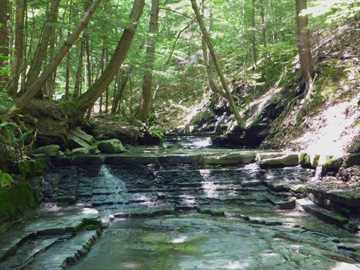
5.10 Reach the boundary of Wolf Creek Falls Preserve, which is owned by the Mohawk Hudson Land Conservancy. The Long Path is coaligned with multiple trails through this preserve. As of summer 2023, there are low-water (standard) and high-water (alternate) route options for the Long Path through this preserve until a new bridge can be built. After significant rainfall, the first crossing of Wolf Creek on stepping stones may be difficult.

Wolf Creek Falls. 2013 [MARK TRAVER]
Low-Water (Standard) Route
5.10 Turn right off Bozenkill Road onto the Red trail. Proceed through the woods and reach Wolf Creek on stepping stones.
5.35 Soon after the creek crossing, turn left onto the White Trail and continue along the creek to progressively larger waterfalls. The largest waterfall is approximately 25 feet tall and 50 feet wide.
5.50 Reach an intersection with the Blue and White trails and turn left onto the Blue Trail. Proceed past a private bridge, then bear left at an intersection with the Green Trail to continue on the Blue Trail.
5.60 Reach an intersection with the Blue and Yellow trails and turn left onto the Yellow Trail. Descend to cross Wolf Creek on the Musical Bridge; if you strike the ends of the treads with the attached mallet, the treads play different tones of a musical scale. Continue uphill toward the road.
5.70 Reach Bozenkill Road and turn right (west) to follow the road.
*High-Water (Alternate) Route
*5.10 After significant rainfall, continue following Bozenkill Road west for about 100 feet and turn left to enter the woods on the south side of the road at a sign for Wolf Creek Mini Falls. Follow the Red Trail south along a tributary of Wolf Creek and pass several small waterfalls, then turn left onto the White Trail.
*5.45 Reach an intersection with the White and Yellow/Gold trails and turn right onto the Yellow/Gold trail. Follow this trail downhill toward the road.
*5.60 Reach Bozenkill Road and turn left (west) to follow the road. Continue with the description below, but add 0.1 mile to the mileage numbers.
7.30 Turn right onto Colliton Road (also known as Ostrander Road) and then right onto Bozie Hollow Road. Pass the old Ostrander Cemetery on the left. There is little blazing from here to the Schoharie Turnpike.
8.40 Cross railroad tracks and the Albany/Schenectady County line, where the name of the road changes to Bozen Kill Road. The Bozenkill Falls can be heard through the fencing on the right. A gristmill was once at its base. (DO NOT LEAVE THE ROADWAY - DO NOT TRESPASS OR YOU WILL BE ARRESTED) The rail line was built by the Delaware & Hudson Railroad in 1863 and is now operated by SMS Rail Lines.
9.10 Reach the Schoharie Turnpike (Schenectady County Route 74) and turn left.
9.55 At the top of the hill, on the left, is the Christman Wildlife Sanctuary where a trail leads to the historic “Long Path Lean-to” at the base of a beautiful waterfall. It was built by the Mohawk Valley Hiking Club in the 1930s as a shelter for LP hikers. Mr. W.W. Christman, renowned as the “Poet of the Helderhills,” was highly enthusiastic about the Long Path and owned the land which now comprises the sanctuary. Continue on the Schoharie Turnpike.
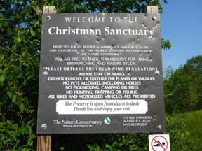
Christman Sanctuary. 2014 [JAKOB FRANKE]
Previous Section: Section 35
Next Section: Section 37
37. Christman Sanctuary to Featherstonhaugh State Forest
Section 37: Christman Sanctuary to Featherstonhaugh State Forest
Quick Facts
Distance: 10.0 miles
Parks: Christman Sanctuary, Featherstonhaugh State Forest
Maps: Interactive Map
Print-Friendly Version: Link
General Description
From Christman Sanctuary the Long Path follows local roads until it reaches Featherstonhaugh State Forest. Along the way it passes through the Hamlet of Duanesburg. In Featherstonhaugh State Forest the trail follows ski trails and snow mobile trails, until it reaches Judith Lane.
Access
From the NY State Thruway (I-87 N) merge onto I-90 W. In about 10 miles take exit 25A and merge onto I-88 W toward NY-7/Schenectady/ Binghamton. In 6 miles take exit 24 toward NY-7/US-20/Duanesburg, then turn left onto US-20 E. Continue about 2 miles and turn right onto Schoharie Turnpike. The Christman Sanctuary parking area is on the left in about 3 miles.
Parking
0.00 Christman Sanctuary parking area. (42.74320°, -74.12875°)
5.80 Schenectady County Forest trailhead parking lot. (42.80174°, -74.15425°)
8.00 Featherstonhaugh State Forest parking area on Lake Road. (42.81069°, -74.13476°)
8.50 Featherstonhaugh State Forest parking area at Tidball Road. (42.80926°, -74.12870°)
10.00 Featherstonhaugh parking lot on Judith Lane (limited). (42.81148°, -74.11646°)
Camping
9.00 Frosty Acres Campground at 1560 Skyline Drive. Follow Tidball Road 0.8 miles to the end, then turn left on Skyline Drive for 0.65 miles.
Camping in Featherstonhaugh State Forest is allowed, but subject to the standard DEC rules and regulations.
Trail Description
0.00 From the Christman Sanctuary parking lot turn left onto Schoharie Turnpike.
0.80 Turn right on Weaver Road (Schenectady County Route 152). Cross under I-88 to reach New York State Route 7.
1.80 Go right on Route 7
2.70 Reach the intersection with New York State Route 20 in the Hamlet of Duanesburg. There is a diner at the corner. Turn left on Route 20 and pass under a railroad bridge to reach Duanesburg Churches Road (County Route 127) on the right. James Duane (1732-1797), the founder of Duanesburg, is buried here in a vault under the church.
 Duane's 1792 church. 2013 [MARK TRAVER]
3.95 Follow Churches Road north to Lake Road (County Route 88).
6.50 Turn right on Lake Road and continue east.
7.25 Pass a Schenectady County Forest parking area on the left.
7.65 Reach the western boundary ofFeatherstonhaughStateForest where the Long Path turns left into the woods. Reach a junction with a ski trail and turn right. Cross under a power line and at the next ski trail turn right.
8.25 Cross Lake Road. The Long Path follows the ski trail and bears left at the first trail junction. After crossing the third stream on a foot bridge, reach a second ski trail junction, then turn left to reach a snowmobile trail.
8.65 Turn right on the snowmobile trail that parallelsLake Road near a parking area. Before the snowmobile trail reaches a swamp, the Long Path heads left to reach Lake Road with a wide mowed bank. Follow the road bank to the junction of Lake Road and Tidball Road.
9.00 Cross Lake Road to the trail and state forest on the north side of the road. Reach a junction with a ski trail and turn left.
9.80 Reach another trail junction - left leads to a DEC dock with a view of the lake.
10.00 The Long Path turns right at the junction and ascends to reach small DEC parking area on Judith Lane. Canoes can be launched here.
 Featherstonhaugh Lake. 2013 [MARK TRAVER]
Previous Section: Section 36
Next Section: Section 38
38. Featherstonhaugh State Forest to the Mohawk River
Section 38: Featherstonhaugh State Forest to the Mohawk River
Quick Facts
Distance: 9.7 miles
Parks: Featherstonhaugh State Forest, Plotter Kill Preserve, Empire State Trail, Lock 9 State Canal Park
Maps: Interactive Map
Print-Friendly Version: Link
General Description
This section is mostly road walking through scenic farm country. In the beginning there are several vistas of the Rotterdam Hills and the Helderbergs. During the first half of this route there are great views to the south and east of the Catskills, Berkshires, and confluence of the Mohawk and Hudson River valleys. The only off-road section the trail passes through is in the Plotter Kill Nature Preserve in the Town of Rotterdam, where a short side trip will lead to some pretty falls. Toward the end of this section the trail follows the Mohawk-Hudson bike path along the old Erie Canal for a while. Section 38 ends in the Canal Park at Lock #9 (currently closed), immediately after crossing the Mohawk River. The blazing on this section is sporadic.
Access
From I-87 N/NYS Thruway, keep straight onto I-90 W/NYS Thruway. In 4.7 mi take exit 25; take ramp on right for I-890 toward Schenectady. At exit 2A, take ramp on right for Route 337 toward Campbell Road, then bear right onto Route 337 (Rice Road). In 0.8 mi bear right onto Putnam Road (County Route 54), and in 1.8 mi turn right onto Route 159 (Mariaville Road). Continue 5.5 mi, then turn left onto Lake Road (County Route 88). In 0.3 mi bear right onto Judith Lane, and in 0.2 mi arrive at the parking area of Featherstonhaugh.
Parking
0.00 Featherstonhaugh Boat Launch Parking lot on Judith Lane. (42.81148°, -74.11646°)
6.40 Plotter Kill Preserve parking lot off Gregg Road. (42.84646°, -74.02944°)
9.70 Lock #9CanalPark. (42.87962°, -74.04102°)
Camping
Camping in Featherstonhaugh State Forest is allowed, but subject to the standard DEC rules and regulations.
Trail Description
0.00 Continue straight (east) on Judith Lane.
0.20 Turn left on Lake Road.
0.50 Turn right on Route 159 (Mariaville Road), and continue east.
2.70 Turn left onto Rynex Corners Road and in 100 feet turn right onto Gifford Road and driveway (#132 Rynex Corners Road).
3.00 The blazed LP trail leaves the town maintained road/driveway to the right, by the unmaintained section of the old town road, and descends toward the creek.
3.20 A few feet before reaching the site where the road crossed on a bridge many years ago, the trail heads left through the woods and parallels the creek. Just upstream from the bridge there was once a grist mill on this side of the creek and a saw mill on the other.
Plotter Kill. 2014 [JAKOB FRANKE]
3.40 The LP leaves the creek bank and climb a side-hill slope to the left.
3.50 Emerge at a T intersection of a well maintained pathway and turn right.
3.60 Turn right from the pathway and descend to the creek again. The trail passes a small foundation hole which was the site of a “spinney”, a little shack where a spinster lived for many years back in the early 1800s. Follow along the creek, then turning to the left, climb up to the ridge and reconnect to the pathway.
3.70 Turn right and continue on this pathway.
3.80 Cross two foot bridges to reach a stone wall which is the Gifford-Plotter Kill Preserve’s boundary. (The LP blazes end here and we now follow preserve blazing which is maintained by Schenectady County.)
3.90 Continue straight ahead to the intersection with the preserve’s Highland Trail and continue straight on the yellow blazed trail.
4.00 Following a zigzag, the trail turns left to reach the end of the yellow-blazed at the junction with the red blazed North Rim Trail. Continue straight on this red trail, heading NNE.
4.10 Pass the large waterfalls on the right. Use extreme caution in this area as many visitors have been injured here.
4.30 Reach another junction with the yellow trail. Continue on the red trail which swings to the left and ascends the rim of Rynex Creek. Start to descend by way of switchbacks to the creek. Follow the creek downstream to a shallow crossing just above the waterfalls. (There is no bridge here and the crossing may be impassible during high water events, use extreme caution here.)
4.40 Cross Rynex Creek and climb steeply on old steps to the ridge top and then start a steady descent.
4.60 Reach a trail junction from the right. Stay straight on the rim trail.
4.80 After a quick left-right jog, the trail crosses under power lines.
5.00 Continue to descend, cross an access road and follow the trail along the rim again.
5.10 Pass by a trail junction from the right which crosses the gorge to the south rim.
5.20 Pass by a yellow blazed trail on the right.
5.30 The trail bears left and crosses two small streams.
5.70 Pass under another power line.
5.90 Reach a trail junction on the left where a #7 sign is nailed to a tree on the right; leave the red trail, turning left onto a trail marked with red disks over white paint.
6.10 The trail swings left and in 200 feet swings back right to cross a foot bridge.

Plotterkill Preserve trailhead on Gregg Road. 2013 [MARK TRAVER]
6.40 Reach another foot bridge and the Gregg Road trailhead parking area. Continue north by once again following LP blazes on Gregg Road past the intersection with Crawford Road, under the NYS Thruway and over the railroad tracks to a T intersection.
6.90 Turn left and continue west for a short distance on NYS Route 5S.
7.10 The trail turns left to join the Mohawk-Hudson Bike Path, which runs just south of the Mohawk River along sections of the old Erie Canal.

Erie Canalway. 2013 [MARK TRAVER]
7.55 Turn right onto a paved road (Mabie Lane), which will lead the LP back to Route 5S.
7.75 Turn left onto Route 5S and cross railroad tracks.
8.20 On the right is the historic Jan Mabie House built in 1705, with two styles of early Dutch architecture. Enter the Hamlet of Rotterdam Junction.
9.10 Turn right on Spruce Street and left on Leonard Street to reach Bridge Street, NYS Rte. 103. Go right and cross over the Mohawk River/Erie Canal with the destroyed Lock 9 State Canal Park on the right.
9.25 Turn left on Riverside Drive.
9.35 Turn right onto Bridge Street (NY Route 103) and cross the Barge Canal Lock #9 Bridge over the Mohawk River.
9.70 Turn right into the parking lot and picnic area of Canal Park at Lock #9. This is the end of this section, and the starting point for the description of the Long Path in northern Schenectady County. It is also one of Vincent Schaefer’s original Long Path landmarks. (The park is currently closed because of construction. Instead proceed to the junction of Routes 3 and 5. On the other side of the junction is a Stewart's and the section temporarily ends there.)

Route 103 bridge across Mohawk River. 2013 [MARK TRAVER]