33. Lawton Hollow Road to Switz Kill
Section 33: Lawton Hollow Road to Switz Kill
Alerts
- The description has been updated with a major relocation through the Partridge Run area that was established in summer 2023.
Quick Facts
Distance: 12.45 miles
Parks: Partridge Run Wildlife Management Area
Maps: Interactive Map
Print-Friendly Version: Link
General Description
Section 33 of the Long Path mostly follows a mix of old ski trails and snowmobile trails and newer footpaths through both Partridge Run Wildlife Management Area and Partridge Run State Forest. The walking is not difficult and there is little elevation gain, just small ups and downs. The exceptions are at the beginning and end of the section, where the Long Path must climb up to the plateau of Partridge Run. The first 0.3 miles and the last 0.2 miles are on paved roads. Some of the park trails are also accessible by vehicle, but are little used. The trail passes through many reforestation areas, primarily of Norway spruce and red pine. There are also several ponds and lakes along the way. Views are limited, but more numerous when the leaves are down. Because skiers and snowmobilers share the trails in the winter, there are a number of wet areas, particularly in the beginning of the section.
Access
Take the New York State Thruway to Exit 22 in Selkirk. Turn right on NY Route 144 and go south to NY Route 396. Turn right on Route 396 and follow it 6 miles to South Bethlehem, where Route 396 ends. The road becomes Albany County Route 301 here. Follow Route 301 west another 6 miles to its terminus at NY Route 443 in Clarksville. Turn left on Route 443 and follow it 11 miles to the village of Berne. Continue on Route 443 another 3 miles to West Berne. In West Berne, turn left on Albany County Route 9. Follow Route 9 for about a mile until it makes a sharp left. Continue straight ahead on Bradt Hollow Road. Follow Bradt Hollow Road for about 3 miles, where it intersects Lawton Hollow Road. Turn right on Lawton Hollow Road and follow it for 1.55 miles to the intersection of of Canady Hill Road.
Parking
0.30 East shoulder of Canady Hill Road. (Unlocated)
2.30 Off Bradt Hollow Road. (42.58265°, -74.20622°)
6.15 Tubbs Pond. (42.56730°, -74.18128°)
6.90 Fawn Lake. (42.56185°, -74.16544°)
7.90 Partridge Run Road and Ravine Road (Albany County Route 6). (42.56118°, -74.15094°)
8.40 End of Partridge Run Road. (Unlocated)
9.50 Shale Forest Road. (Unlocated)
12.45 Switz Kill Road and Gifford Hollow Road. (42.57715°, -74.11854°)
Camping
Camping is allowed in Partridge Run, but only in the reforestation areas, not in the Wildlife Management Areas, and 150 feet away from the trail or water source. There is a lean-to 150 yards straight ahead at the right turn to reach Gifford Hollow Road (12.05 mi).
Trail Description
0.00 This section starts at the intersection of Canady Hill and Lawton Hollow Roads, continuing south on Canady Hill Road. Note that during hunting season, the regular route of the Long Path described here is closed and a roadwalk detour starting on Lawton Hollow Road is necessary. This roadwalk detour is described at the bottom of this section description.
0.30 Turn left and enter the woods on private land, just prior to reaching a house on the right and the intersection of Bassler Road. The trail follows a stone wall for some distance.
0.50 The trail leaves the woods road, crosses a small drainage and then starts uphill through the woods.
0.85 Near the top of the hill the trail intersects a snowmobile trail and follows it for a short distance. The trail leaves the snowmobile trail and starts downhill.
1.40 Cross a small drainage, turn left on an old road for a short distance, then turn right heading uphill.
2.10 Reach the top of the hill and turn right.
2.30 The Long Path enters the Partridge Run Wildlife Management Area, with the boundary marked in yellow paint. The trail continues straight on the Nordic ski trail, bordering an area that was clear-cut several years ago. Reach an intersecting trail and bear right. In a short distance another ski trail connects from the right. The Long Path leaves the ski trail on the left through a brushy area and into fairly open woods following stone walls and logging roads. The trail emerges back on the ski trail at the iron gate on High Point Road.
2.85 Reach High Point Road at a gate, and turn left (east) and uphill. Soon pass a small parking area on the right.
2.95 Turn right off the road into the woods shortly after the parking area. The trail meanders through second growth red pines, then turns left to cross the remnants of a stone wall. After crossing the wall, the trail turns right at the border of a mature red pine plantation with open woods.
3.15 Reach an old logging road and turn left (south). Descend to cross a seasonal stream that is rarely more than a couple inches deep, then reach a large, first growth pine and turn left up a small hill. The trail parallels the side of the hill for a short distance and then descends through open woods and down to the left of a stone wall that parallels the logging road.
3.30 At the end of the stone wall, reach the Bradt Hill Ski Trail and turn left, heading uphill. In about 0.1 mile, turn right into the woods for a short distance to avoid a wet area before rejoining the ski trail.
3.45 Turn left off the Bradt Hill Ski Trail, staying uphill near the edge of a large red pine plantation with some remarkably large trees and attractive, open woods. Turn right where the trail approaches two very large pines and a logging road.
3.55 Reach junction with white-blazed spur trail that proceeds 0.05 mile to a parking area across Bradt Hill Road. Turn right and cross remnants of a stone wall, then turn left past some very large pines.
3.60 Reach Bradt Hill Road and turn right to follow along the road, soon passing the gate for the end of the Bradt Hill Ski Trail on the right.
3.65 Turn left off the road into the woods, cross the remnants of a stone wall, and turn left to wind through large white and red pine.
3.75 Reach a gap in the stone wall and turn right. The trail parallels the wall for a short distance before heading into more second growth red pine, some of which are very large.
4.00 Reach the Blue Ski Trail, a logging road, and turn right. This area is marked for logging, so there may be limited blazes over the next 0.1 mile. This trail will remain intact and safe through the logging activity, which is anticipated in winter 2024.
4.10 Reach the Yellow Ski Trail and turn left, following a small "Trail" sign and a sign for Beaver Road. Note that from this junction to mile 5.65, the Long Path is in Partridge Run State Forest instead of the Wildlife Management Area. The Yellow Ski Trail, which occasionally includes blue markers as well, proceeds along a winding logging road through large, red pine trees. The trail parallels a stone wall on two sides of an old field and then heads downhill, then turns right at a junction where an unmarked logging road continues straight.
4.50 Turn right at a junction with an unmarked logging road, then quickly turn left up into the woods after a large balsam tree within view of the trail junction. The trail angles away from the Yellow Ski Trail and soon bears left.
4.70 Reach a gap in a stone wall and turn right, paralleling the stone wall with a line of large maples.
4.85 Turn left and downhill away from the stone wall, around a very large pine, then proceeds to the right through an open area and more woods.
4.95 Cross an intersection with a logging road/horse trail that was also the former Long Path route prior to this 2023 relocation. The trail winds through large pines, across a seasonal stream with stepping stones, and past a number of large, old trees. It eventually crosses another seasonal seep and stream and proceeds around a plateau and uphill to follow a stone wall below pine plantation marked for eventual cutting activity. The trail soon heads downhill and makes a sharp left turn approaching Beaver Road.
5.65 Cross a junction with the old Horse Trail near its junction with gravel Beaver Road, and proceed straight to reach the road. Turn left (north) to follow Beaver Road.
5.85 Turn right off the road and follow a snowmobile trail downhill through a mature stand of spruce and pine.
6.15 Reach Tubbs Pond, turn right, cross the outlet of the pond to the right on a foot bridge, and reach the Tubbs Pond parking area. The trail follows the cinder Tubbs Pond access road.
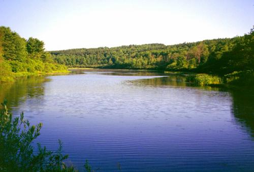
Tubbs Pond. 2001 [ED WALSH]
6.55 Reach intersection with Fawn Lake Road, turn right and follow it as it parallels Fawn Lake on the right.
6.90 Reach the end of the road and Fawn Lake parking. The trail turns left on a woods road and descends along a gorge following Fawn Lake’s outlet stream. To the left are the remnants of a 1930s deer management area.
7.35 Reach a trail intersection. The trail to the left leads to White Birch Pond. The Long Path turns right, crosses a stream on a bridge, and heads east toward White Birch Pond Road.
7.60 Reach White Birch Pond Road and turn right.
7.80 The trail jogs left on Ravine Road (Albany County Route 6), then right on Partridge Run Road. There is room to park several cars.
8.10 A path leads right about 100 feet to a waterfall along the stream.
8.35 Partridge Run Road bears right and crosses the stream. The Long Path bears left away from the stream, reaches a parking and picnic area at the end of the road, then continues straight ahead through a gate on a gravel road. The trail passes a small pond on the right.
8.75 Intersect a snowmobile trail that goes left. Continue right on the gravel road, intersecting another trail in 500 feet. The trail left leads to Wood Duck Pond. The Long Path bears right.
9.15 Reach a shale road (Kingfisher Road), and turn right.
9.50 Turn left, reach a parking area and continue on a snowmobile trail.
9.70 Reach the crest of the hill and turn right to descend. There are views of the Blackhead Range here when the leaves are down. The trail swings left to reach the eastern escarpment, then left again to follow it.
10.05 Following Partridge Run’s eastern escarpment north, there is a view across Gifford Hollow to Cole Hill.
10.35 The trail bears left, switchbacks uphill beneath a rock ledge, then continues north on the escarpment.
10.60 Reach an old woods road and turn right.
10.90 The trail turns right on another woods road and descends down to a level area before climbing again.
11.10 Reach the bottom of the hill, turn right and enter a hemlock grove, gently climbing again.
11.25 Turn left on another faint woods road, leave Partridge Run and begin descending to the Switz Kill. The trail enters private property.
11.40 The trail turns right and descends through the woods. It emerges on an overgrown field and continues east, following a hedgerow. Watch for the blazes to be sure you are in the correct field. At the end of the first field, cross a stream in a hedgerow and follow the hedgerow across a second field.
12.05 The trail almost reaches the east edge of the field and turns right onto a field drive to reach Gifford Hollow Road. Straight ahead at the turn, about 150 yards, is a lean-to built by Adam Forti from Boy Scout Troop 79 as an eagle scout project in 2011-2012. The fire place at the lean to was built by Eagle Scout Joe Staubach from Troop 79. The campsite is maintained by Troop 79 and the landowner.

Lean-to at mile 12.05. 2012 [MARK TRAVER]
12.25 Reach Gifford Hollow Road and turn left.
12.45 Gifford Hollow Road intersects Switz Kill Road (Albany County Route 1), where this section ends. Turn right on Switz Kill Road to continue.
During hunting season, the beginning of the Long Path in this section is closed. Follow the roadwalk detour, which is 0.4 mile longer, as described below:
0.00 At the intersection of Canady Hill and Lawton Hollow Roads, turn left (east) on Lawton Hollow Road.
1.10 Reach a shale bank on the left, with room to park a couple of cars. This is the Albany County boundary line. The trail continues east on Lawton Hollow Road.
1.70 Turn right onto gravel Bradt Hollow Road and head uphill. In approximately 0.6 mile, the trail enters Partridge Run Wildlife Management Area.
2.45 Turn right off the road onto a woods road. There is room to park several cars here, but the parking area is accessible only during the dry season. Just beyond the parking area, follow a snowmobile trail over a knoll, then descend into the woods following the northern boundary of Partridge Run Wildlife Management Area.
2.70 Reach the regular route of the Long Path near the boundary of the WMA. Turn left (south) and follow the description from mile 2.30 above (be sure to add 0.4 mile to each mileage entry to account for the increased length of this roadwalk detour).