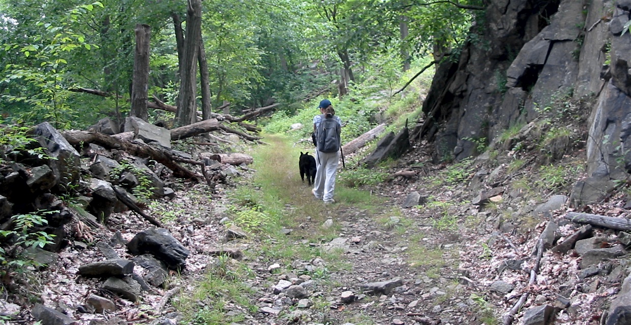
Railbed

South County Trailway

Historic: 
Complete: 
No
The former railbed of the "Old Put" line Photo: Jane Daniels
NYNJTC maintained: 
0

The South County Trailway passes through residential, highly industrial, commercial as well as wooded areas, wedged, for much of its length, between the Saw Mill River Parkway and the New York State Thruway. .

Hiking
Mountain biking
Accessible
Dogs on leash
14 miles
48 acres
Westchester
NY
Cluster/Park: 
Park

Like its northern partner, the North County Trailway, the South County Trailway uses the right of way of the Putnam Division of the New York Central. Between 1881-1958, this railroad ran for 54 miles between the Bronx and Brewster in Putnam County. Passenger service ceased in 1958, but freight service continued until 1982. 

Occasional remnants of the rail like, structures such as tracks, ties, whistle sign, foundationa, and old telephone poles are found along the South County Trailway. At former stations sites, interprestive signs provide the history of the railroad and details about that station and its community. 

Because of proximity to the Saw Mill Parkway, the NYS Thruway, and the Saw Mill River, there are far fewer access points to the South County Trailway than along a comparable length of the North County Trailway. Parking is available at
Eastview commuter lot [41.082434N 73.830832W];
Route 100 C at the northbound off ramp [41.080484N 73.829329W];
Great Hunger Memorial Park (Woodlands) [41.025132N 73.845710W];
Lawrence Street at Route 9A [41.001507N 73.853894W];
Farragut Avenue [40.983005N 73.865981W];
Barney Street [40.976195N 73.867681W];
Redmond Park [40.938349N 73.869254W]; and
Tibbetts Brook Park [40.926636N 73.874899W].
Landowner: 
County
Manager: 
Westchester County Parks
Region - Maintenance: 

North County Trailway

Historic: 
Complete: 
Yes
Fall colors along the North County Trailway Photo:Jane Daniels
Wetlands in Yorktown Photo: Jane Daniels
NYNJTC maintained: 
0

As you travel the North County Trailway, you will see a cross section of Westchester as it passes back yards, parks, and businesses. Along its route, it wends its ways through a variety of habitats; wetlands, rock cuts, woodlands and edge environment.

Hiking
Mountain biking
Accessible
Dogs on leash
21 miles
88 acres
Lat/Lon: 
41.214674, -73.783900
Tarrytown, Briarcliff Manor, Millwood, Yorktown Heights, Somers, Baldwin Place
Westchester
NY
Cluster/Park: 
Park

Most of the time, the Trailway is away from roads. Between Millwood and Briarcliff Manor, the trailway is just a barrier away from high speed Route 100. 

The Yorktown Trail Town Committee has installed maps of the business area of Yorktown Heights. See www.yorktowntrailtown.org

Most of the time, the Trailway is away from roads. Between Millwood and Briarcliff Manor, the trailway is just a barrier away from high speed Route 100. The Trailway is primarily a bicycle route, so hikers should be alert for passing cyclists.

A two-page brochure, "North County Trailway," developed by Westchester County Department of Parks, Recreation and Conservation Department with an overview and maps is available online.


There are many access points to the trailway, including some from neighbor's backyards. Use a map of Westchester County to reach parking areas at Baldwin Place, Route 202/35, Underhill Avenue in Yorktown, Route 118, Route 134, Millwood, Chappaqua Road, Law Park in Briarcliff Manor and Eastview.

Fees: 
None
Modified By: 
Jane Daniels
Landowner: 
County
Manager: 
Westchester County Parks
Region - Maintenance: 

Timp-Torne/Dunderberg Spiral Railway/R-D Trail Short Loop from Route 9W

Timp-Torne/Dunderberg Spiral Railway lower tunnel - Harriman-Bear Mountain State Parks - Photo: Daniel Chazin
Stone abutment of railway - Timp-Torne/Dunderberg Spiral Railway - Harriman-Bear Mountain State Parks - Photo: Daniel Chazin
NYNJTC maintained: 
1
Summary: 

This loop hike follows portions of the never-completed Dunderberg Spiral Railway and passes several expansive viewpoints over the Hudson River.

3 hours
Moderate to Strenuous
4 miles
Route type: 
Circuit
Allowed on leash
Historic feature
Views
Historic: 
Harriman-Bear Mountain State Parks
NY
Rockland
119 Northern Harriman Bear Mountain Trails
08/28/2008
04/20/2016
Driving: 

Take the Palisades Interstate Parkway to its northern terminus at the Bear Mountain Circle and proceed south on U.S. Route 9W for about four miles. At the base of a downhill section of the road, as the road reaches the river level, you’ll notice a large parking area on the right side of the road. (A side road, Old Ayers Road to Jones Point, leaves sharply to the left here.) Park in this gravel parking area. 

From the parking area, walk south on Route 9W for a few hundred feet. Just beyond road signs for Routes 9W and 202, you’ll see three blue blazes and three red-dot-on-white blazes on a tree adjacent to the road. These blazes mark the start of the Timp-Torne (blue) and Ramapo-Dunderberg (red-dot-on-white) trails. You’ll be following the Timp-Torne Trail for the first part of the hike and returning on the Ramapo-Dunderberg Trail.

Reference/Source: 
Bergen Record: Hike of the Week

South Beacon Mountain Firetower and Scofield Ridge

Beacon reservoir from fire tower - Photo: Daniel Chazin
NYNJTC maintained: 
1
Summary: 

This hike climbs to the firetower atop the summit of South Beacon Mountain and follows the Scofield Ridge, passing many panoramic viewpoints over the Hudson River and the surrounding mountains.

7 hours
Strenuous
8 miles
Route type: 
Circuit
Allowed on leash
Historic feature
Public Transportation
Views
Historic: 
Hudson Highlands State Park Preserve
East Hudson Highlands
NY
Dutchess
102 East Hudson Trails North
06/02/2006
08/17/2014
Driving: 

From the east end of the Bear Mountain Bridge, proceed north on N.Y. 9D for 14.5 miles. As NY 9D (Wolcott Avenue) curves sharply to the left at Bob’s Corner Store in Beacon, turn right onto Howland Avenue. Immediately, turn right into the parking area for Scenic Hudson’s Mount Beacon Park.

Train: 

Take the Metro-North Hudson Line to the Beacon station. The trailhead is approximately 1.5 miles from the train station.  To reach the trailhead from the station turn right (south) onto Beekman Street (towards Dia Beacon).  In 0.4 mile, Beekman Street ends, and you should continue along Wolcott Avenue (Route 9D).  In about another mile, Wolcott Avenue makes a sharp right turn.  At this bend, turn left onto Howland Avenue.  The trailhead is on your right.

This hike begins with a steady, steep climb of 1,000 feet of elevation in the first mile, and the overall elevation gain exceeds 2,000 feet. It is not an easy hike, but the spectacular views that it affords are ample reward for the strenuous ascents. Much of the land traversed by the hike has been protected through the efforts of Scenic Hudson, which preserves open space in the Hudson River valley.

Reference/Source: 
Bergen Record: Hike of the Week

Dunderberg Spiral Railway/Bald Mountain Loop

Along a grade of the Dunderberg Spiral Railway - Photo by Daniel Chazin
NYNJTC maintained: 
1
Summary: 

This loop hike follows portions of the never-completed Dunderberg Spiral Railway, climbs to the summit of Bald Mountain, and passes several expansive viewpoints over the Hudson River.

6 hours
Strenuous
7 miles
Route type: 
Circuit
Allowed on leash
Historic feature
Views
Historic: 
Harriman-Bear Mountain State Parks
NY
Rockland
119 Northern Harriman Bear Mountain Trails
12/12/2002
11/23/2022
Driving: 

Take the Palisades Interstate Parkway to its northern terminus at the Bear Mountain Circle and proceed south on U.S. Route 9W for about four miles. At the base of a downhill section of the road, as the road reaches the river level, you’ll notice a large parking area on the right side of the road. (A side road, River Road to Jones Point, leaves sharply to the left here.) Park in this gravel parking area.

From the parking area, walk south on Route 9W for a few hundred feet (there are trail blazes along the roadwalk). Just beyond road signs for Routes 9W and 202, you'll see three blue blazes and three red-dot-on-white blazes on a tree adjacent to the road. These blazes mark the start of the Timp-Torne (blue) and Ramapo-Dunderberg (red-dot-on-white) trails. You'll be following the Timp-Torne Trail for the first part of the hike and returning on the Ramapo-Dunderberg Trail.


Reference/Source: 
Bergen Record: HIke of the Week

Atsion to Carranza Monument

Carranza Monument - Photo by Daniel Chazin
NYNJTC maintained: 
0
3 hours
Easy
6 miles
Route type: 
Shuttle/Two car or Public Transportation
Allowed on leash
Historic feature
Birding
Wharton State Forest
Pinelands
NJ
Atlantic
04/29/2011
Driving: 

Directions using two cars for a shuttle hike

  • To Carranza Monument, from the North: NJ Turnpike South to Exit 7. Follow signs for 206 south. Drive approximately 14 miles south on 206 to the Red Lion Circle (70/206). Continue on 206 south through the circle approximately 1 mile. Bear left off 206 onto Carranza Road (Rt. 648). Drive approximately 1.5 miles to first stop sign. Continue through the Route 532 stop sign (Nixon's General Store on the left and Russo's farm store on the right) on Carranza Road in Tabernacle. After a couple miles of sparsely settled farm land and small affluent developments you will enter Wharton State Forest. Go past the turnoff for the old NJ Correctional System Boot Camp and continue another 1.8 miles. The Carranza Memorial site will be in a clearing on your right.  [Drop off a car]
  • From Carranza Monument to Atsion office:  From the Memorial retrace your route along Carranza Road; in about four miles turn left onto Forked Neck Road.  Travel 3.1 miles to the intersection with Route 206 at the Valenzano Winery.  Turn left, travel another 3.4 miles; the sign for the Atsion office is ahead on your left, just before Atsion Lake on your right.

Directions using one car to hike out from and back to Atsion office, from the North: NJ Turnpike South to Exit 7. Follow signs for 206 south. Drive approximately 14 miles south on 206 to the Red Lion Circle (70/206). Continue on 206 south through the circle approximately 1 mile. From the intersection of Route 206 and Route 648, proceed South on Rt. 206 for another 9 miles until you enter Wharton State Forest.  The sign for the Atsion office is ahead on your left, just before Atsion Lake on your right.

Starting at the parking lot of the historic Atsion office, head southeast on Quaker Bridge Road past a hunting club and boarded-up schoolhouse on your right and look for the Mullica (yellow) Trail on your left.

Reference/Source: 
Jeff Jotz, public hike, edited by Phil McLewin