Due to the ever-changing nature of trails, our maps, even if accurate when published, may not show new or relocated trails that have been established after the map was printed. Any changes, omissions, or other updates that are not included on the published map set and that are important for hikers to be aware of will be posted here.
If you have any errors or updates to report, please leave a comment on this page or contact Jeremy Apgar by clicking here.
- - - New Trail Update - A new trail has been established in Silas Condict Park, and it is not shown on the current edition of Map 125. This white-blazed trail is described in this hike description: Silas Condict County Park White Trail. Note that the parking areas at Silas Condict Park are reached by following the park entrance road (William Lewis Arthur Drive) and not Ricker Road as shown on the map.
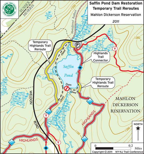
- - - Trail News - The Highlands Trail has been temporarily rerouted in Mahlon Dickerson Reservation. The dam at Saffin Pond's outlet is being restored, and to keep park visitors away from the work area, the Morris County Park Commission has established temporary trails and closed the picnic area at the dam. The project began in April, 2011, and it is expected to take 10-12 months, after which the temporary trails will be removed.
The Highlands Trail typically crosses the dam. Approaching the dam from the east, the Highlands Trail turns right to follow a short temporary trail (currently marked by red flagging tape) then a connector trail (currently marked by teal diamonds with black dots) north to the parking area. The Highlands Trail then follows orange construction fencing to the northwest corner of the parking lot before entering the woods and following a temporary trail south. This section of trail is currently marked by red flagging tape and appears freshly raked and cut, and it is fairly easy to follow. Just south of the dam, this temporary trail meets up with the previous route of the Highlands Trail, where there is orange construction fencing and signage about the reroute.
The following map shows the temporary trail reroutes established by the Morris County Park Commission. The Highlands Trail is shown with gray outline as it now follows two separate temporary trails (yellow lines) in combination with a trail on the east side of Saffin Pond that typically serves as a connector trail to the parking area. Closed sections of trail are indicated by thick black dashes with small 'X' marks, with the dam itself noted by a Keep Out symbol.

Back to Jersey Highlands Trails: Central North Region main page
