 New York-New Jersey Trail Conference
Southern Loop at Apshawa Preserve
Directions to trailhead
Take I-287 to Exit 53 (Bloomingdale) and turn left onto Hamburg Turnpike. Upon entering Bloomingdale, the name of the road changes to Main Street. When you reach a fork in 1.3 miles (from I-287), bear right, but at the next fork (in another 0.1 mile), bear left to continue on Hamburg Turnpike. Follow Hamburg Turnpike for another 1.1 miles, then turn right onto Macopin Road (County Route 693). In 1.9 miles, turn left onto Northwood Drive. Proceed for 500 feet and turn right into the parking area for the Apshawa Preserve.
Hike Description
The Apshawa Preserve is a rugged 576-acre tract owned by Passaic County and the New Jersey Conservation Foundation. About seven miles of trails traverse the preserve, and this hike features the trails in the southern section of the preserve. The trails are marked with paint blazes and with colored plastic diamond blazes, some of which incorporate the logo of the New Jersey Conservation Foundation.
At the northern end of the parking area, go through a gate in a deer fence and follow the Blue Trail, which first proceeds along a woods road, but continues on a footpath. After crossing a wet area on puncheons, the Blue Trail bears left and descends to cross a stream on a wooden footbridge. It then climbs a hill on a woods road, passing on the left the start of the Purple Trail. Continue ahead on the Blue Trail, which bears right at a high point and climbs some more, passing interesting rock formations on the left. Just beyond, the trail turns left, leaving the woods road, climbs over a rise and descends steeply into a ravine, where it turns left onto another woods road.
A short distance ahead, the White Trail begins on the right, but you should continue on the Blue Trail, which follows a relatively level woods road. After descending a little and looping around a vernal pond, you’ll pass the start of the Orange Trail on the left. This will be your return route, but for now, continue ahead on the Blue Trail.
 Soon, the trail crosses a broad expanse of open rock with several cedar trees and descends to Apshawa Brook, where the Blue Trail ends at a junction with the Green Trail. Turn right onto the Green Trail, which loops around, then turns left and crosses the brook on a metal bridge just before reaching a gate (do not go through the gate). Here, the Red Trail joins.
Continue to follow both green and red blazes as the trail climbs to a T-junction with a gravel road. Turn right onto the road, which leads in a short distance to a viewpoint over the Butler Reservoir, which has been officially renamed the Kathleen M. Caren Memorial Reservoir (due to safety concerns, the historic stone dam has been breached and a concrete spillway constructed to lower the water level of the reservoir). After taking in the view, return to the junction and continue ahead on the road.
After passing a small wetland on the right, follow the Green Trail as it turns left, leaving the road, and goes through a gate.  The Green Trail now begins a gradual but steady climb on a woods road, traversing an open deciduous forest with no understory. After passing through mountain laurel thickets and bearing left at a fork, the trail reaches the summit of a hill. Rock outcrops on the right afford views to the south and west, although the views are partially obscured by trees.
After pausing to take in the view, continue ahead on the Green Trail. You’ll pass interesting rock formations on the left and begin a steady descent on a winding footpath. Parts of the descent are rather steep.
At the base of the descent, the trail turns left onto a woods road which parallels Apshawa Brook. It heads uphill, passing beautiful cascades in the brook, below on the right. A short distance ahead, you'll come to a fork. Bear right, following the green blazes, and descend to the brook.
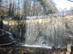
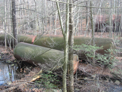
To your right, you'll notice four huge rusted tanks that were installed as part of a water purification system in the early 1900s. Here, the trail crosses the brook on rocks and turns left, passing the ruins of two small stone-and-concrete buildings. Follow the green blazes upstream along the brook on a rocky footpath. Soon, you'll come to the base of a curved concrete dam, also built in the early 1900s to regulate the flow of water in the brook. The trail bears right and climbs to the top of the dam, with a nice view over the small reservoir that has been impounded behind the dam.
The Green Trail climbs through mountain laurel and hemlock, then bears left at a gate in the deer fence (don’t go through the gate). The trail now descends a little, then levels off. After a short climb on a rocky path, the Green Trail bears left, but you should continue straight ahead, now following the Orange Trail. The Orange Trail continues to the top of a rise, levels off, then descends to end at a junction with the Blue Trail. Turn right onto the Blue Trail and retrace your steps back to the parking area where the hike began.