 New York-New Jersey Trail Conference
Bare Rock Trail to Greenwood Lake Overlook
Directions to trailhead
Take the New York Thruway to Exit 15A. Turn left at the bottom of the ramp onto Route 17 and head north for 1.4 miles to the exit for Sterling Forest. Follow Sterling Mine Road (County Route 72) west for 3.0 miles, then turn right onto Long Meadow Road (County Route 84). Proceed north on Long Meadow Road for 3.5 miles, then turn left onto Old Forge Road and continue for 0.5 mile until you reach the Sterling Forest State Park Visitor Center. Park in the parking lot on the right side of the road, then cross the road to the visitor center, where there are informative exhibits.
Hike Description
 Leave the park visitor center, using the front entrance, and turn right on a dirt path, following the blue blazes of the Sterling Lake Loop. The trail briefly joins the paved entrance road, then bears right and goes across a grassy field, passing the stone foundations of a former church on the right. It enters the woods on a footpath and soon reaches a junction with the yellow-blazed Lakeville Ironworks Trail.
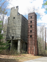
Turn left onto this trail, which passes the remains of the Sterling Furnace, built in 1770 and abandoned in 1804. The structure you see was rebuilt in the 1950s by the City Investing Company. After going across paved Old Forge Road, you'll pass an old house, a remnant of the Lakeville mining community, and cross a stream on a footbridge. The trail then crosses another paved road and climbs through a pine forest to an opening of the Sterling Mine, carved into the hillside. Iron ore was discovered in the area as early as 1736, and mining operations continued until 1923. The trail passes concrete-and-brick ruins of several buildings from the mining era and the opening of the Lake Mine (whose deep shaft extended under Sterling Lake), then descends to paved West Sterling Lake Road.
Turn left onto the road, once again following the blue blazes of the Sterling Lake Loop. The road now runs alongside Sterling Lake, affording views across the lake.
Soon, the road curves to the right. In another 200 feet, a sign marks the start of the Bare Rock and Fire Tower Connector Trails. Turn left, leaving the blue-blazed trail, then immediately turn right and continue along the orange-blazed Bare Rock Trail, which crosses a stream on a footbridge and climbs on an old woods road. The trail generally follows this road up the Sterling Ridge, but it has been routed off the road in several places to avoid wet and badly eroded sections. Follow the orange blazes for about three-quarters of a mile, climbing steadily, until you reach the crest of the ridge at a junction (marked by a sign) with the blue-on-white-blazed Sterling Ridge Trail and teal-diamond-blazed Highlands Trail.
Continue ahead on the Bare Rock Trail, which levels off, then narrows to a footpath and descends to cross a stream and reach the green-blazed West Valley Trail, a woods road. Bear left and continue to follow the orange blazes along this road. In a quarter mile, follow the orange blazes as they turn right and head west, descending on an old woods road. Soon, the trail turns left and briefly parallels a stream. After again turning left and crossing the stream on rocks, the trail climbs to the top of the ridge. Here, it reaches a junction marked by a sign “Bare Rock Vista.”
Turn right and descend rather steeply on a side trail, marked with binocular-logo-on-orange blazes. You’ll emerge onto Bare Rock – a spectacular viewpoint over Greenwood Lake. From this vantage point, you can see the entire six-mile-long lake, with Bellvale Mountain - the route of the Appalachian Trail - in the background. You'll want to take a break here to enjoy the panoramic view.
When you're ready to continue, climb back to the main trail and turn right. The Bare Rock Trail heads south along the ridge, with views of the lake through the trees. It bears left and descends into a valley, then climbs on switchbacks and continues to head south along a slightly higher ridge.
In a third of mile, the Bare Rock Trail bears left and crosses the ridge to reach an east-facing viewpoint, with the Sterling Forest Fire Tower visible directly ahead. You’ll soon be climbing this tower! From the viewpoint, the trail bears right and continues to descend. After crossing an intermittent stream in a hollow, the trail climbs to a large open rock ledge and passes some interesting boulders. It crosses another intermittent stream, descends through a hemlock grove, and ends at a at a woods road – the route of the white-stripe-on-red-blazed Fire Tower Trail and the green-blazed West Valley Trail.
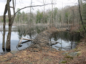
Turn left onto the woods road, following the white-stripe-on-red and green blazes. In a quarter of a mile,  where the two trails diverge, bear right to follow the white-stripe-on-red-blazed Fire Tower Trail. The former route of this trail (a woods road) has been flooded by a beaver dam (visible just ahead), and the trail has been rerouted to a footpath south of the flooded area. Soon, the trail bears left, crosses a stream on rocks, skirts the flooded area, and rejoins the woods road.
Follow the road for half a mile to a junction with the blue-on-white-blazed Sterling Ridge Trail and the teal-diamond-blazed Highlands Trail. Turn left, now following three trails – the Fire Tower Trail, the Sterling Ridge Trail and the Highlands Trail.
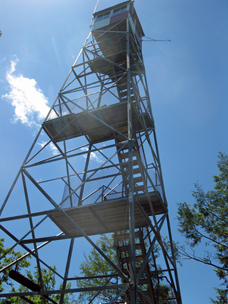
After a short level stretch, the trail turns sharply right and climbs very steeply over rock ledges to reach a south-facing viewpoint from open rocks amid pitch pines. This is another good place to stop and take a break. The trail now descends to cross an intermittent stream on rocks, then climbs again – with two steep climbs interrupted by a short level stretch. At the top of the second climb, it reaches another, more limited south-facing viewpoint. The trail then levels off and soon reaches the Sterling Forest Fire Tower.
 Built in 1922, the fire tower affords an impressive 360° view of Sterling Forest and the surrounding area. Sterling Lake is in the foreground to the northeast, Cedar Pond may be seen to the south, and a portion of Greenwood Lake is visible to the west. On a clear day, North and South Beacon mountains of the East Hudson Highlands may be seen in the distance to the northeast, and Schunemunk Mountain is visible to the north, with the Catskills on the horizon.
When you're ready to continue, proceed east on the white-stripe-on-red-blazed Fire Tower Trail, which descends steadily from the ridge on a woods road (used by vehicles to access the fire tower). After about a mile, where the road levels off, you'll come to a junction. The Fire Tower Trail turns off to the right on a branch road, but you should continue ahead on the main road, now marked with red-triangle-on-white blazes as the Fire Tower Connector Trail. The road continues to descend, and after passing a private residence and going around a locked gate, it ends at a junction with the blue-blazed Sterling Lake Loop, near the shore of Sterling Lake. Turn right and follow the blue blazes back to the visitor center, where the hike began (note the left turn off the paved road in about a third of a mile).