 New York-New Jersey Trail Conference
Appalachian Trail - Kent, CT to Cornwall Bridge, CT
Directions to trailhead
I-87 to Saw Mill River Parkway North for 18 miles; merge on to I-684 North. After 11 miles, I-684 North ends and becomes NY-22; keep straight on NY-22 for another 18 miles. Turn right on NY-55 for just under 2 miles, turn left on Dogtail Corners Road. Follow Dogtail Corners Road around as it enters CT and becomes Bulls Bridge Road. Cross the single-lane Bulls Bridge watching for oncoming traffic. Just after the covered bridge, turn left at the stoplight on US-7/Kent Road. Proceed almost 4 miles to CT-341. Keep straight on US-7 but note the intersection at CT-341 – this will be the turn for parking the second car to start the hike. Continue on US-7 for almost 9 more miles. Stay with US-7 as it bears left and Route 4 joins in from the right at the stop sign. Cross the bridge over the Housatonic River, keep right on US-7 when Route 4 leaves to the left then turn right again immediately at that same intersection on River Road downhill towards a church. (If you come to hiker parking on the left side of US-7 you missed the River Road turn and can turn around here – the turn is very easy to miss.) River Road veers right at the church and parallels the river heading south. Drive another 1.5 miles and park at the pullout on the left just before the Appalachian Trial sign. In the second car return to US-7 heading south back towards Kent. Turn right on CT-341 in Kent and continue just under a mile to pullout parking on the left across from AT sign and stile.
NOTE: In lieu of a second car, a dog-friendly shuttle service is offered by Backcountry Outfitters (860-927-3377), located on CT-341 .6 mile east of the start of this hike.
Hike Description
Several map boxes are located along the latter half of this route. Although these maps offer a very nice overview of the entire section of the Appalachian Trail that passes through Connecticut, it gives no details specific to this hike. More detail for this hike is shown on this topo map.
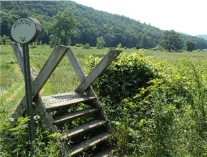
 From the start of the hike at the parking pullout on CT 341, cross the road and climb the stile over the barbed wire fence. Continue through the cow pasture, cross Macedonia Brook on a bridge, then head uphill into the woods following the white blazes of the Appalachian Trail northbound.
Almost 1 mile into the hike, watch for a view to the right of the Connecticut countryside. Continue through the woods crossing a couple of small creeks then cross Choggam Brook at the 3-mile point. In another tenth of a mile, cross paved Skiff Mountain Road then continue more steeply uphill. After a level stretch, the trail switchbacks up the rest of the way reaching a very nice overlook at Calebs Peak 3.9 miles into the hike.
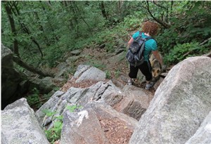
 Continue downhill from Calebs Peak then descend somewhat steeply down a series of stone steps. In another half-mile watch for a sign on a tree announcing St. Johns Ledges, turn right downhill leaving the AT for a short distance to a rock outcrop for a view. Return to the AT and continue heading north, arriving at a precipitous descent in a few hundred feet. Although it may look daunting, 90 stone steps installed by Appalachian Mountain Club volunteers and a professional trail crew make the descent manageable but hands may be needed for balance and leverage every so often. After this knee-jarring descent you might reconsider the difficulty when witnessing rock climbers ascending the adjacent sheer rock face from the bottom up.
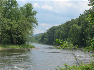
 Shortly after the trail levels out, proceed through a parking lot then turn left on gravel River Road. Having reached the half way point of this hike, the rest will be easy going on nearly flat and smooth surfaces. This is a very unique part of the Appalachian Trail as it is one of the longest flat stretches of the entire trail. The next mile of the AT follows River Road, which is open to traffic for those driving to the parking spaces at the dead end. Watch for nice views up and down the length of the Housatonic River just before the gated end of River Road. Continue to other side of the gate towards a kiosk as the AT becomes a footpath.
This path will now follow along the Housatonic River, sometimes at river level, sometimes a little higher. Old stone farm walls and fields will often come into view on the left. At the 7.3-mile point, cross Stewart Hollow Brook on a split log bridge and pass the blue-blazed trail that leads to the Stewart Hollow shelter. In another half mile pass the blue-blazed trail to the Stony Brook campsites and cross Stony Brook on a log bridge.
Almost 9 miles into the hike, the AT skirts a small open area on the right where milkweed grows in abundance and colorful butterflies frolic in season. Shortly after leaving this field, enter hay fields on the left and follow the AT as a narrow path skirting the edge of Liner Farm with views of neighboring mountains. In the second field an old stone silo can be seen on the opposite side.
Shortly after leaving the farm fields, cross a log bridge then a quarter of a mile later turn right on a gravel road leaving the AT. Follow this gravel road for a quarter of a mile back to the first parked car.
Turn-by-Turn Description
[ 0.00] Cross CT 341 and climb stile at AT sign; cross meadow
[ 0.20] Cross bridge over Macedonia Brook, enter woods and cross unmarked trail
[ 0.90] View on the right
[ 1.80] Cross small creek
[ 2.50] Cross small creek
[ 3.00] Cross Choggam Brook
[ 3.10] Cross paved Skiff Mountain Road
[ 3.25] Seasonal overlook
[ 3.40] Cross small creek
[ 3.90] Caleb's Peak
[ 4.10] Rock steps descend
[ 4.60] Leave AT to the right downhill briefly to view at St. Johns Ledges; continue on AT and begin steep descent
[ 4.95] Keep straight when unmarked trail goes right (used by rock climbers)
[ 5.00] At parking area turn left on River Road and follow River Road (gravel)
[ 5.80] Keep straight on gravel River Road when another gravel road goes left
[ 5.95] Continue through parking area and gate towards kiosk; AT becomes footpath
[ 7.30] Cross log bridge over Stewart Hollow Brook; blue side trail goes to Stewart Hollow Shelter
[ 7.40] Other end of blue-blazed trail from Stewart Hollow Shelter comes in from the left
[ 7.80] Blue-blazed trail to left goes to Stony Brook campsites, keep right on log bridge over Stony Brook
[ 7.90] Other end of blue-blazed trail from Stony Brook campsites comes in from the left
[ 8.95] Go through small field on the right
[ 9.05] Trail veers left into Liner Farm fields
[ 9.35] Trail leaves farm fields
[ 9.40] Cross log bridge
[ 9.65] Trail comes out on gravel road, turn right and follow gravel road
[ 9.90] Back at car spotted at beginning of hike