 New York-New Jersey Trail Conference
Shavertown Trail on Perch Lake Mountain in Catskills
Directions to trailhead
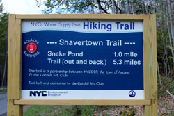
The Shavertown Trailhead is located on BWS Rd 4, about 200 feet west of the parking lot for the Shavertown Boat Launch on the Pepacton Reservoir. Parking is provided at the Boat Launch parking area, located on BWS Rd 4 just west of that road’s intersection with State Route 30. From the parking area walk along BWS Rd 4 and you will come to the start of the Shavertown Trail. A trail information sign has been installed at the start of the trail with information and mileage.
Hike Description
This intermediate trail ascends from near the shoreline of the Pepacton reservoir to Snake Pond and then continues to climb upwards, along a shoulder of Perch Lake Mountain. The trail offers families and novice hikers something of a unique opportunity in the Catskills – a spectacular view after only one moderately strenuous mile of hiking, followed by a fairly level mile and a half through beautiful rock ledges and wonderful forests to explore.
 After walking westward along BWS Rd 4 and reaching the Trailhead signage, you turn right onto the trail marked with red NYCDEP plastic trail markers. The trail climb the earthen bank next to the roadway, cross a small drainage and then begin ascending steadily through an open forest and soon reaches an old woods road.
The trail follows the old woods road, crossing a generally dry drainage on stepping stones. The trail then takes a hard right turn, leaving the old woods road and climbing quickly. Several stone steps have been installed on this section. The trail then intersects another old woods run, taking a hard left turn and following the woods road. That woods road then ends at the intersection with a well maintained and wide woods road. The trail turns right onto the wide woods road and again ascends steadily at a moderate pace.
The woods road turns slightly to the left and soon enters the lower end of a large open field on the mountainside. As the trail makes its way through the field, a weather station is located to the right of the trail. Make sure to avoid touching or otherwise damaging any of the sensitive instruments. The trail now climbs through the middle of the open field along the woods road, passing another smaller weather station on the right. Views begin opening up to the south and west and the Pepacton Reservoir can be seen in the valley below you.
The trail following the woods road curves to the left near the upper portion of the field and looking downhill, you have an outstanding view to the south and west of the surrounding mountains and a small portion of the reservoir that is visible below you. Shortly ahead of the top of the field, the trail reaches a trail junction with the short Snake Pond Trail, approximately one mile from and about 520 vertical feet above the trailhead on BWS Rd 4. During the spring and summer, wildflowers bloom all throughout the open fields, making for a very scenic walk.
The trail junction is marked with a directional sign, indicating the Snake Pond Loop and the trail heading back down to the trailhead and up the shoulder of Perch Lake Mountain.

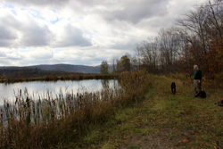
The Snake Pond Trail forms a short loop around Snake Pond. The trail descends slightly from the trail junction, skirting around the eastern shore of the pond, then crosses the outlet and crosses the earthen dam on the southwestern side of the pond. The pond is located at the top of an open field and the trail along this section offers almost constant views of the surrounding mountains and the Pepacton. The trail follows the earthen embankment until it ends in the woods at the uphill end of the pond. This made for a great place to relax and have a sandwich while we took in the pond and the view beyond. The trail skirts around the wooded uphill side of the pond before coming back out into the open field and rejoining the just before the trail junction.
Past the trail junction, the main Shavertown Trail reenters the woods on a woods road and begins ascending at a moderate pace through an open hardwood forest. The grade soon moderates and the trail continues ascending slowly through a series of short climbs interspersed with generally level stretches. There are a few eroded and wet sections along the way, but the majority of the tread is solid and dry, which makes for a pleasant walk along the flank of Perch Lake Mountain and if you are hiking the trail in the late fall, winter or early spring, there are numerous views along the trail through the trees.
 The trail continues to follow the old woods road as rock ledges begin appearing uphill to the right of the trail. Shortly afterwards the trail turns left, leave the woods road and entering into a boulder field. The trail makes its way through the lichen, moss and fern covered boulders before ascending through a break in the rock ledges and making its way over to the base of the mountain slope. The trail follows the base of the mountain slope on a somewhat rougher tread than the old woods road. A steep slope rises to the right above the trail and several rock ledges and boulders are visible as you walk. The trail then turns to the right and rejoins the old woods road, following the road to the height of land and starting to descend slightly before turning off the road once again to the right and climbing through a series of rock ledges and then follows the edge of those left until rejoining and turning left on to another woods road.
From this point the remaining majority of the trail is almost level. The trail follows the old woods road past a thick hemlock and evergreen forest to the right and the ridge of Perch Lake Mountain descending to the left. The trail then passes through the hemlock grove and reaches the start of the small loop that forms the end of the trail. The best way to the follow the loop is to stay to the left when you reach the unsigned trail junction along the ridgetop. The trail makes its way along the ridge, then descends slightly, before beginning to climb gently while passing a very large red maple tree on the right. The trail then joins an old woods road and ends at the unsigned trail junction you had passed earlier.
From this point, the only way to return to the trailhead is to follow the trail that you had ascended back down Perch Lake Mountain, past the Snake Pond Loop and down to BWS Rd 4 and the parking area. The total distance from the trailhead to the end of the loop is 2.65 miles for a total round trip distance of 5.3 miles. The total ascent from the trailhead is 760 vertical feet.