 New York-New Jersey Trail Conference
Watchung Reservation History Trail
Directions to trailhead
Take U.S. Route 22 West to Summit Road in Mountainside. Turn right onto Summit Road and continue for 1.2 miles to Summit Lane. Turn left onto Summit Lane. When you reach a traffic circle in 0.7 mile, take the second exit to continue on Summit Lane. In 0.5 mile, the road turns right and becomes New Providence Road. Continue for another 0.2 mile to the parking area for the Trailside Nature and Science Center (on the right, where the road makes a sharp left turn).
Hike Description
Proceed west (downhill) on the extension of New Providence Road, marked with the white blazes of the Sierra Trail. Turn left opposite a “Do Not Enter” sign and head into the woods. You’ll immediately pass a kiosk with a triple-pink blaze, marking the start of the History Trail. You will be following the History Trail for the entire hike.
Pick up a copy of the History Trail brochure and map and follow the white and pink blazes downhill to cross a wooden bridge over a brook. The trail continues through the woods and, after crossing two smaller wooden bridges in quick succession, reaches a junction with the Yellow Trail. Turn left, now following both pink and yellow blazes.
After a straight, relatively level stretch, the joint pink and yellow trails bear right at two junctions and continue along a section with many curves. The trails turn right at a T-intersection, but at the next junction, turn left and continue to follow the pink blazes of the History Trail, as the Yellow Trail proceeds straight ahead.
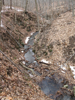
The History Trail now begins to parallel a small gorge to the right. After making a sharp bend to the left, the  gorge deepens and becomes more spectacular. Towards the end of the gorge, you’ll pass an historical marker that provides information on exploratory copper mine shafts in the area.
The History Trail now climbs a little and bears right at a fork, briefly joining the white-blazed Sierra Trail. After descending for a short distance, the two trails diverge. Here, you should bear left to continue on the pink-blazed History Trail, which begins to parallel the Blue Brook, below on the right. Soon, the trail descends to the level of the brook, and it turns right and crosses the brook on a wide wooden bridge with stone abutments. On the hillside above, you can see several historic homes of the Deserted Village of Feltville.
On the other side of the brook, the trail turns left, then bears left at a fork and continues to parallel the brook. A short distance ahead, it passes an historical marker for the Feltville Mill Site, with stone ruins of the mill visible along the hillside. Beyond a sharp bend in the brook, the History Trail bears right andheads uphill, away from the brook.
After passing an historical marker for Hermit’s Pond, the History Trail bends to the right and reaches a junction with the white-blazed Sierra Trail. Here, the History Trail turns sharply left and begins to run jointly with the Sierra Trail. In a quarter mile, you come to another junction. Turn left, descend wooden steps and continue downhill to a marker at the site of the Drake Farmhouse. Then retrace your steps to the junction and continue ahead, passing a marker for the Drake Barn.
In a short distance, the trail bears right and begins to parallel Glenside Avenue, with I-78 just beyond. For the next mile, the trail runs roughly parallel to these two roads. Although you can hear the sounds of traffic on the busy I-78, the concrete noise barrier walls that have been installed along this highway substantially reduce the noise level, and this stretch of trail is actually quite pleasant to hike. Be alert for a left turn in about a third of a mile.
After paralleling Glenside Avenue for about half a mile, the History Trail emerges onto a grassy expanse and reaches a parking area at Cataract Hollow Road. Follow the trail as it crosses the road and re-enters the woods, continuing to parallel Glenside Avenue but now following a wide dirt road.
Soon, the trail moves closer to Glenside Avenue and goes by the Old Scout Camporee Field on the right. Continue ahead, parallel to Glenside Avenue, as two roads go off to the right, and soon reach another open field, known as the Corn Field (with an historical marker). Beyond the Corn Field, the trail bends to the right and re-enters the woods. It begins a steady descent towards Surprise Lake, bearing left at a fork.
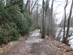
As the trail approaches the shore of the lake, the white-blazed Sierra Trail joins from the right. Bear right at the  next fork and continue along the lakeshore, now following both pink and white blazes. When you reach the northeastern tip of the lake, turn right, cross the road bridge over the inlet, then immediately turn right again and continue along the southeastern side of the lake. You’ll pass several historical markers and traverse an attractive area lined with evergreens and rhododendron bushes.
Beyond the historical marker for the Lake Surprise Bathhouse, the trail bears left and climbs away from the lake. It turns left at the next intersection, then turns right at a wide cleared strip of land and proceeds past a Scout camping area on the right. Continue ahead to the extension of New Providence Road, then turn left and proceed uphill on the road to the parking area where the hike began.