29. West Conesville to Doney Hollow
Section 29: West Conesville to Doney Hollow
Alerts
- Trail access through the former Nickerson Park Campground (now Nickerson Catskill Mountain Campground) is no longer available, so the description has been updated with a roadwalk route between the campground and Mine Kill State Park. This roadwalk route has shortened the overall length of this section by 2.25 miles (from 13.55 miles to 11.3 miles).
Quick Facts
Distance: 11.3 miles
Parks: Mine Kill State Park, Historic Lansing Manor
Maps: Interactive Map
Print-Friendly Version: Link
General Description
In this section, the Long Path leaves the rugged terrain of the Catskills and descends into the Schoharie Valley. After passing the Schoharie Reservoir, which is the northernmost outpost of the New York City water supply system, the Long Path begins a 30-mile journey along the Schoharie Valley and the hills surrounding Schoharie Creek. The trail passes through Mine Kill State Park, whose primary attraction is Mine Kill Falls. The Long Path passes both the top and the bottom of the falls, which plummet out of a spectacular gorge. Between the falls and the main part of the park, the trail follows a beautiful pine and hemlock forest. In the north end of the park are spectacular open views of the Schoharie Valley. Beyond Mine Kill State Park, the trail passes through the Lansing Manor Visitors Center of the Power Authority’s Blenheim-Gilboa pumped storage complex. There are expansive views up the Schoharie Valley from both Mine Kill State Park and Lansing Manor.
Access
Take the New York State Thruway to Exit 21 (Catskill). Continue west on NY Route 23 for about 30 miles to the Village of Prattsville. At the end of Prattsville, NY Route 23 crosses a steel bridge that goes over Schoharie Creek. Just before the bridge, turn right on Prattsville Road, and follow it for about 5 miles to the intersection of Prattsville Road and Route 990V.
Parking
0.00 Intersection of NY Route 990V and Prattsville Road. (42.38064°, -74.43084°)
5.95 Mine Kill State Park, at north end of swimming pool, when park is open. (42.43785°, -74.45867°)
6.70 Lansing Manor Visitors Center. (42.44886°, -74.46452°)
11.30 West Kill Road at Doney Hollow. (42.48519°, -74.48447°)
Camping
3.35 Campsites available at Nickerson Catskill Mountain Campground (fee charged).
Camping is allowed in the state reforestation areas 150 feet from the trail and water.
Trail Description
0.00 At the intersection of Prattsville Road and NY Route 990V, the Long Path turns left and follows NY Route 990V downhill toward Gilboa. On the left side of the trail is the Schoharie Reservoir.
0.90 Reach the Gilboa-Conesville Central School on the right side of the road. To the left is the former site of the Gilboa Settlement. From 1840 to 1869, a cotton mill, tannery, church and cemetery stood on the ground that is now covered by the Schoharie Reservoir.
1.00 After passing the school, bear right on Wyckoff Road.
1.15 Opposite the school playground, turn left into the woods.
1.25 Reach the NYC DEP watershed land property line. Follow the property line for a short distance and continue downhill through mixed woods.
1.55 Reach the intersection of Route 990V and Flat Creek Road, near the Gilboa Town Hall and Post Office. On the right, just past the town hall, is an exhibit of fossilized trees that were discovered while constructing the Schoharie Reservoir. The Long Path continues along NY Route 990V, which curves left and goes downhill.
1.80 The Long Path crosses Schoharie Creek on a bridge. There is a small cemetery to the right, just past the bridge.
2.00 Turn right onto Stryker Road. Pass the Gilboa Museum on the right (open only on summer weekends; check the website for more information).
2.50 Reach a "Road Closed" gate. On the left is a large farm and site of Rockland Cider Works. Walk around the gate to proceed along the road that is closed to vehicles for the next 0.75 mile, with views of Schoharie Creek to the right.
3.25 Reach the other "Road Closed" gate at the intersection of Cresent Road, and continue straight on Stryker Road.
3.35 Pass the entrance to Nickerson Catskill Mountain Campground and continue along Stryker Road.
4.35 Reach junction with NY Route 30 and turn right. To the right, Reed Hill is visible in the distance.
4.65 Reach the Mine Kill Falls Overlook parking lot. A short detour here provides access to a walkway that leads to an overlook of Mine Kill Falls. Continue straight on NY Route 30.
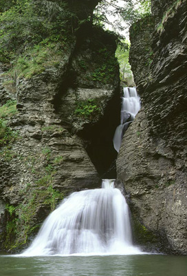
Mine Kill Falls. 2001 [MICHAEL WARREN]
4.80 Cross a bridge over the Mine Kill, with views of Mine Kill Falls below, and then immediately turn right off the road onto a footpath that enters the woods.
4.85 Turn left, with views of the Mine Kill to the right. The trail crosses a small stream.
5.05 A white-blazed trail comes in from the right.
5.15 Cross a stream on a bridge. To the left is a beautiful cascading waterfall. The trail climbs continuously from here to the park entrance road, passing several rock piles on the right part way up. Near the top, two trails lead right, but the Long Path continues straight ahead.
5.45 Emerge onto an open field and cross the main park entrance road. The Long Path continues along the western edge of an open field to reach the park administration building.
5.55 Reach the park administration building on the right, where there are restroom facilities. The trail bears left and follows a mowed path at the western edge of an open field with scattered evergreens. From this path, there is a spectacular view up and down the Schoharie Valley.
5.75 Turn right and descend along the northern boundary of a soccer field, then pass a small playground just north of the swimming pool.
5.95 Turn left and follow a cross-country ski and snowmobile trail that leads from Mine Kill State Park to Lansing Manor. Here, there is a spectacular view north along the Schoharie Valley and across the Blenheim-Gilboa Reservoir. Soon, a yellow-blazed cross-country ski trail leaves to the right, but the Long Path continues straight ahead. The trail soon leaves Mine Kill State Park and enters the New York State Power Authority Lansing-Manor Blenheim-Gilboa complex; the boundary is not marked.
6.30 Reach an open field with scattered cedar trees. Note the fences around small cedar trees. These trees are pruned so as to provide the deer with a source of browse, and the fences prevent the deer from killing the trees. There are also a number of bluebird feeders. Bue sure to watch for Long Path blazes on top of fence posts by the cedar trees.
6.70 Reach a picnic area and cross the parking lot of the Lansing Manor Visitors Center. At the far end of the parking lot, the trail follows a walkway through the Visitors Center, where brochures on the historic Lansing Manor and the Blenheim–Gilboa pumped storage power plant are available. Brochures are also available at the nearby museum. There are picnic tables at the Visitor Center, making this an ideal lunch stop in the warm months.
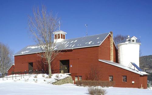
Lansing Manor Visitors Center. 2001 [MICHAEL WARREN]
6.85 Take the left fork in the walkway and pass the entrance to the museum. The Long Path now heads across a field with trees, skirts a wooded area on the right, then turns right and cuts diagonally across another field to enter the woods in 0.25 mile.
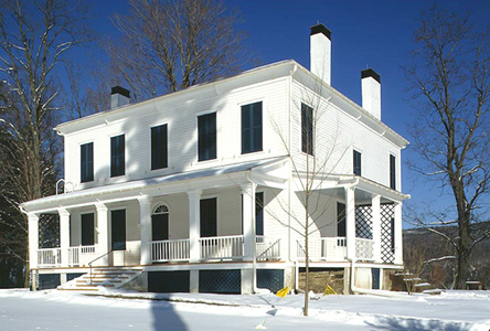
Lansing Manor. 2001 [MICHAEL WARREN]
7.15 After a rather steep descent, reach the bottom of a ravine. The trail now ascends gradually and crosses a powerline right-of-way.
7.40 Reach the top of a hill, with a view down to the dam of the Blenheim-Gilboa Reservoir. During periods of low electrical demand, water is pumped up the hill to the reservoir. During periods of high demand, the water is released, thus generating electricity.
7.80 Turn left down a bank to cross a small stream, then turn right to reach the NY Power Authority's North Access Road. Turn left onto the road, and in about 100 feet turn right off the road onto a trail down the bank. Note that this trail into the woods down the steep bank may be difficult to spot.
7.95 Bear left just before reaching the Schoharie Creek. This section, which may be overgrown at times, has views of the creek throughout. During flood conditions, this section may be flooded and it will be necessary to instead walk the access road to NY Route 30.
8.35 Turn left up a ladder next to a measurement station to reach the Power Authority's North Access Road, then turn right to follow the road.
8.50 Reach NY Route 30, turn right to cross a bridge over West Kill, then immediately turn left onto Creamery Road. Soon, you will pass a cemetery on the right.
8.75 Turn right uphill into the woods at the very end of the cemetery, across from house #137 on the left. In about 0.1 mile, pass a stone wall. Soon, you'll reach a hedgerow and pass another stonewall on the right.
9.00 Reach a field and cut diagonally across the corner of the field to reach a hedgerow, and turn left.
9.10 Go down a short, steep bank to West Kill Road and turn left to follow the road.
9.30 Reach the intersection of West Kill Road (Schoharie County Route 43) and Burnt Hill Road. Continue left on West Kill Road.
9.50 Just past a driveway, turn left into the woods.
9.65 Cross West Kill Road to the north side of the road, making a short left-right jog. Note that from October 10-December 15, this section is closed to hiking; during this period, turn left onto West Kill Road and follow the road for about 0.8 mile, past the beaver pond on the right, and turn left into the woods 100 feet past a DEC boundary sign.
9.80 Turn left onto a woods road.
10.00 Turn left, leaving the woods road, and in 0.1 mile turn left again back onto the woods road.
10.45 Turn left and downhill, toward a beaver pond.
10.60 Reach the DEC State Reforestation Area boundary.
10.65 Cross West Kill Road to the south side of the road and descend to West Kill. The trail continues west along the creek.
11.05 Turn right away from the creek and climb back up to West Kill Road. Turn left onto the road and follow it for 0.15 mile, across Doney Hollow.
11.30 This section ends where the trail turns right into the woods to follow Doney Hollow. There is room to park several cars in this area.