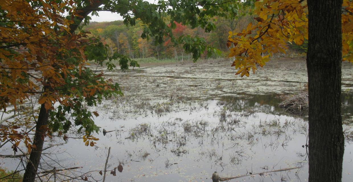
| Park Description: | This unbroken deep-forest habitat is important for the survival of many resident and migratory species, including black bear, a variety of hawks and songbirds and many rare invertebrates and plants. To the east, Sterling Forest is bordered by Harriman State Park; to the south, it abuts New Jersey parklands, including Ringwood State Park, Tranquility Ridge County Park and the Wanaque Wildlife Management Area.
The US Senator Frank R. Lautenberg Visitor Center overlooks Sterling Lake and features exhibits about the local environment as well as an auditorium for related presentations.
Hunting is permitted in the park during hunting seasons. Non-hunters should wear bright clothing. |
| Trails Overview: |
There are 27 marked trails in Sterling Forest, some of which are briefly described below. Hikers should be aware that the Trail Conference only maintains about half of these trails and that blazes frequently have a secondary strip in a contrasting color to the blaze color indicated on the 2008 edition of the Sterling Forest Map. Mountain bikers should check with the park to determine which trails they can use.
- One of the oldest trails in the area, the Allis Trail [4.1 miles blue] connects the Sterling Ridge and Appalachian Trails. The southern end of the trail is on the north side of NY 17A, opposite the parking area for the Sterling Ridge Trail.
- The Appalachian Trail [8.4 miles (in the park) white] traverses the northern section of Sterling Forest. Parking is available at the Elk Pen parking area in Harriman Park, on the south side of Arden Valley Road, 0.3 mile east of NY 17. Limited parking is also available at Lakes Road (County 5).
- The Fire Tower Trail [5.5 miles white stripe on red] crosses Sterling Forest in the east-west direction, connecting Long Meadow Road (County 84) with East Shore Road. The eastern trailhead is on the west side of Long Meadow Road, where limited parking is available. The trail ends at a parking area at East Shore Road. The tower is reached at 2.1 miles from Long Meadow Road. Check with the park office to be sure the tower is open before you leave.
- The Furnace Loop Trail [1.6 miles red] offers a short but rewarding walk. It can be accessed from the Wildcat Mountain Trail parking area along Hall Drive.
- The Highlands Trail [14.6 miles (in the park) teal diamond] Trail highlights the natural beauty of the New York and New Jersey Highlands region and draws attention to this endangered watershed region. Within Sterling Forest State Park and continuing south to County 511 in New Jersey, the Highlands Trail is co-aligned with the Appalachian, Allis and Sterling Ridge Trails. There are no Highlands Trail blazes along the Appalachian Trail, from Lakes Road to Mombasha High Point.
- The Indian Hill Loop Trail [3.6 miles yellow] traverses abandoned farmlands, crossing many old stone walls and climbing to several viewpoints. From NY 17 in Southfields, proceed west on Orange Turnpike (Orange County Route 19) for 1 .3 miles to a sign for 'Indian Hill," then turn right and follow a dirt road to the parking area.
- Several interpretive signs are located along the easy the Lakeville Ironworks Trail [0.6 mile mining motif on yellow]. This trail can be completed in an easy walk of only 1.1 miles when accessed from and returning to the Visitor's Center via the blue Sterling Lake Loop Trail.
- The Sapphire Trail [4.2 miles blue] connects the Harriman station on Metro-North's Port Jervis Line with the Appalachian Trail and (via a short connecting trail) the Indian Hill Loop Trail. The trailhead is on the west side of NY 17, across from the Harriman station. As the trail proceeds southward, with gradual ascents and descents, it passes through a pine grove and traverses a shallow valley with impressive rock outcrops, ending at the Appalachian Trail.
- From the trailhead at the visitor center, Sterling Lake Loop Trail [4.2 miles blue] circles Sterling Lake, following woods roads for most of its route.
- The Sterling Ridge Trail [8.6 miles blue disc on white] trail follows the scenic Sterling Ridge between Hewitt, NJ and NY 1 7A. The 1992, 60 foot tall fire tower is located along the trail. Parking for the southern trailhead is at the intersection of Greenwood Lake Turnpike (Passaic County Route 511) and East Shore Road. Its northern terminus is on NY 17A.
- Forming a loop south of NY 1 7A, the Sterling Valley Loop Trail [6.2 miles yellow] follows woods roads for its entire length. The trailhead is at a parking area on the south side of NY 17A, 1.8 miles east of the village of Greenwood Lake.
- The northern end of the Townsend Trail [1.9 miles green stripe on orange] is reached from the parking area on Hall Drive by proceeding south on the Wildcat Mountain Trail for 0.4 mile. Its southern trailhead is at the Long Meadow Extension Trail. Followed to the right, this trail leads in 1.5 miles to the parking area on Hall Drive, completing a 3.5-mile loop.
- Parking for the southern trailhead of the Wildcat Mountain Trail [3.5 miles yellow] is at the north end of a commuter parking area at the intersection of NY 17 and NY 1 7A. The northern terminus is at the Furnace Loop Trail, a short distance north of Hall Drive, (parking) after crossing Orange Turnpike.
To find detailed descriptions of specific hikes, click here and scroll down the "Parks" column to the name of this park.
|
| Directions: | Visitors Center: From junction of Routes NY 17 & Ny 17 A, take 17 A west 1.4 miles to left on Long Meadow Rd (Rte. 84). Go 3.5 miles to right on Old Forge Rd. Center is one mile on right.
Parking for specific trailheads is described above.
Public Transportation: NJ Transit, Metro-North Railroad, Short Line Bus (Coach USA).
|