Southern Catskills
These sections of the Long Path mark the beginning of the route through Catskill Park. The Catskill Park has spectacular scenery and considerable rugged terrain. It passes over Slide Mountain, the tallest in the Catskills. Nowhere does the Long Path go higher. Small villages nestled in the valleys provide a break from the traverses through dense forests carpeting most of the Catskill Mountains. Most of its route follows DEC trails maintained by the Trail Conference. The trails are generally marked with different colored plastic markers. These are usually the only trail identification except at major trail junctions. The LP aqua paint blaze is reserved for when the trail crosses private property and road sections. As the Long Path changes frequently from one DEC trail to another, hikers must watch carefully for turns and make sure that they are on the proper trail. Most trail DEC junctions have signs that give the trail names and the direction and distance to important points.* At many of these intersections, a plastic Long Path marker indicates the route of the Long Path. Camping is permitted on State land at elevations below 3,500 feet (this elevation is usually marked by signs along the trails), and at locations at least 150 feet away from trails and water. The Long Path also passes several DEC lean-tos and campgrounds.
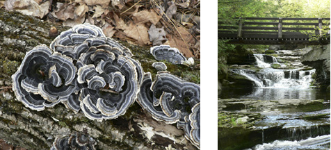
Mushrooms. 2005 and Vernooy Falls. 2006 [JAKOB FRANKE]
_________________________________________________________________________
* The distances given on these signs are not always accurate.
15. Port Ben Road to Riggsville
Section 15: Port Ben Road to Riggsville
Alerts
- This section includes a change in the division point between sections 14 and 15 as of Fall 2023.
Quick Facts
Distance: 11.25 miles
Parks: Vernooy Kill State Forest, Sundown Wild Forest
Maps: Interactive Map, Catskill Trails (map 146)
Print-Friendly Version: Link
General Description
Currently this entire section is on roads, but work is in progress to move it off the roads in connection with a DEC Unit Management Plan for Vernooy Kill State Forest and Sundown Wild Forest. The Long Path starts at the Port Ben Road bridge on the north end of Port Ben, a hamlet in the town of Wawarsing, crossing Rondout Creek and continuing to US Route 209. It follows Route 209 for a short distance, turns north on Lundy Road, then east on Rogue (Rouge) Harbor Road, and then north again on Cherrytown and Upper Cherrytown roads to Riggsville. Although this is currently a roadwalk, there are many fine views and interesting features along the way, and vehicular traffic volume is low on most of the roads.
Access
Take the New York State Thruway to Exit 19 near Kingston, then take NY Route 209 west through Kerhonkson, to Wawarsing. In Wawarsing, immediately after crossing the Vernooy Kill, turn left on Port Ben Road, and follow it 0.7 to the bridge that is closed to vehicles. A parking area on state land is on the left (north) side of the road just prior to the bridge.
Camping
On DEC land.
Parking
0.00 Parking area on state land on the north side of the bridge. (41.75082°, -74.35076°)
2.20 DEC parking lot on Cutler Road. (41.76764°, -74.37148°)
11.25 DEC parking lot on Upper Cherrytown Road. (41.86422°, -74.34615°)
Trail Description
0.00 The Long Path crosses the Port Ben Road bridge across the Rondout Creek, which is now closed to vehicles but is open for pedestrians. A parking area is at the northern end of the bridge. For the next 0.3 mile along Port Ben Road, open farm fields provide great views on both sides of the road.
0.70 Turn right onto US Route 209 and cross the Vernooy Kill. The Wawarsing post office is on the right, next to the stream.
0.80 Turn left onto Lundy Road. Be careful, as Route 209 is a very busy road and oncoming west-bound traffic is coming from a curve.
1.20 Pass the last house on the left. The Vernooy Kill is on the left (south) side of the road.
1.30 DEC land starts on the right. In the next half mile, there are a dam and rapids in the Vernooy Kill and opportunities for swimming. Both Lundy Road and upcoming Rogue (Rouge) Harbor Road are very low traffic roads.
2.20 Cutler Road on the left crosses the stream, with a large DEC parking lot on the west side of the bridge. Future plans are to have the Long Path cross the Vernooy Kill here and then proceed north to Vernooy Falls instead of the roadwalk.
2.55 Pass the first of two old homestead sites on the left. The second site is located 500 feet further on the left.
3.05 Turn right onto Rogue (Rouge) Harbor Road (unpaved). The property on the south side of the road is privately owned.
3.35 A large fence appears on the right (south) side of the road.
3.75 The end of the fence.
3.95 DEC land starts on the left (north) side of the road.
4.30 DEC land now is on both sides of the road.
4.55 A tree on the left contains an old sign (facing east) pointing south to Turner Cemetery. About 300 feet off the road, just to the east of a stone wall, are two head stones.
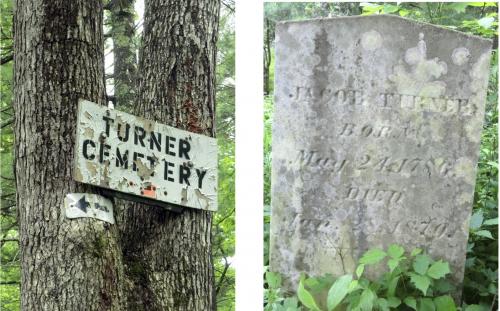
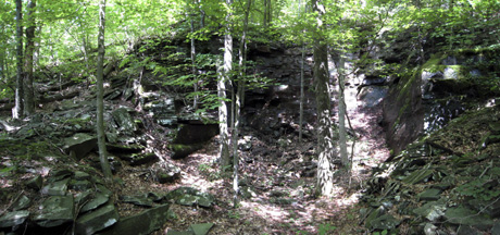
Turner cemetery off Rogue Harbor Road. 2011 [JAKOB FRANKE]
4.75 A DEC parking lot is on the left (north) side of the road.
5.05 End of the DEC lands.
5.35 J&J Road on the right. Rogue (Rouge) Harbor Road becomes paved.
5.70 Woodland Ridge Road on the right. Vehicle traffic may increase.
6.00 The end of Rogue (Rouge) Harbor Road. Turn left onto Cherrytown Road.
7.00 Pass Mt. Laurel Road on the left, continue straight on Cherrytown Road.
8.10 Pass Baker Road on the left.
8.20 Turn left onto Upper Cherrytown Road where Cherrytown Road ends. As it makes the turn, houses are on the left and an old building with garages is on the right.
9.55 Pass White Birch Lane (unpaved private road) on the left, and cross the unsigned Catskill Park boundary.
11.25 The section ends at a DEC parking area on the right side of the road. To continue, turn left and enter the woods on the red-blazed Vernooy Kill Falls Trail.
Previous Section: Section 14
Next Section: Section 16
16. Riggsville to Bull Run
Section 16: Riggsville to Bull Run
Alerts
- As part of recent special regulations for the Blue Hole and Peekamoose Valley at the end of this section, be aware that a permit is required for parking and usage of the area. See details at www.dec.ny.gov/lands/109922.html.
Quick Facts
Distance: 10.1 miles
Parks: Sundown Wild Forest
Maps: Interactive Map, Catskill Trails (maps 143 and 146)
Print-Friendly Version: Link
General Description
The Long Path follows a snowmobile trail to Vernooy Falls, a series of lovely waterfalls. After the cascade, the Long Path leaves the snowmobile trail to follow and cross many dirt roads on gentle grades for the first six miles. The trail becomes narrower and more rugged as it passes the shoulder of Samson Mountain and climbs gently over Bangle Hill. The final descent to Bull Run is steep and long.
Access
Take the New York State Thruway to Exit 19, Kingston. Continue on NY Route 28 west for about three miles, then turn left onto NY Route 28A. At Ulster County Route 3, go west to and through Samsonville. Go right on Sundown Road, then turn left onto Upper Cherrytown Road and follow it to the trailhead.
Parking
0.00 DEC parking area at entrance to Catskill Park on Upper Cherrytown Road. (41.86395°, -74.34630°)
9.65 Sundown primitive campsite on Peekamoose Road. (41.91679°, -74.43791°)
10.10 Parking area on Peekamoose Road (also known as Gulf Road and Ulster County Route 42). (41.91493°, -74.42923°)
Camping
Sundown primitive campsite and state land.
Trail Description
0.00 Opposite a DEC parking area on Upper Cherrytown Road, the Long Path enters the woods at a DEC sign with a red marker indicating a snowmobile trail. Follow the blue hiking trail markers and the large orange snowmobile markers on a wide path. The trail crosses a small stream and begins to ascend.
0.25 Cross a stream on a wooden footbridge and turn right to follow the stream. In another 0.1 miles, pass a piped spring on the left. The trail turns left away from the stream and ascends more sharply as large trees give way to a smaller forest. The trail eventually levels off and crosses several small streams.
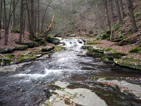
1.70 Reach a clearing with Vernooy Falls, a series of lovely cascades in a large stream, on the left. A number of old foundations are in this area, and the hiker can explore several paths. The Long Path makes a sharp right turn on a wide cobble path as it continues to follow the blue trail markers and the orange markers of the snowmobile trail. After a gradual ascent, the trail levels off. Here, it is often wet.
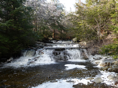
Vernooy Falls. 2008 [JAKOB FRANKE]
2.65 The Long Path turns left up a gentle hill as the orange-marked snowmobile trail continues straight ahead. It reaches a gentle hilltop and becomes fairly level.
3.90 The trail turns left, the Long Path now follows a wide woods road. It crosses a stream on a large culvert. Several dirt roads lead away from the trail. A stream approaches from the left and the trail runs alongside it.
4.60 Cross a tributary stream on a wood plank bridge. The trail passes through hemlock forest before rejoining hardwoods. This section of the trail is often wet.
5.30 Cross a stream on a metal pipe culvert. In 500 feet, another dirt road goes off to the left.
5.60 The Long Path goes right on a narrow track, leaving the woods road. The trail climbs, often fairly steeply, until it reaches an abandoned woods road. Here it turns left on level ground. (For reverse direction, the turn off this woods road is a few hundred feet before the road curves to the left.)
6.10 At a small crest in the woods road, the Long Path turns right on a footpath, leaving the road. A few hundred yards further on, it makes a sharp left on a well-defined path. The general trend is gently downhill as it crosses several small streams.
7.95 The trail jogs left and runs along a level grade with a sharp drop to the right.
8.65 After reaching the top of Bangle Hill, the trail descends steeply, and then turns left and continues along a nearly level contour.
8.85 Cross a rocky intermittent stream, turn right, and head downhill, parallel to the stream. It is now steep downwards all the way to the base of Bangle Hill. On the way down, the trail crosses the stream two more times. It then crosses the outlet of a spring and continues along the valley of the stream. The trail widens into a woods road and passes several other woods roads on the left.
At the bottom of Bangle Hill, near Peekamoose Road. 2012 [JAKOB FRANKE]
9.65 Reach Peekamoose Road (Ulster County Route 42) and turn right, passing a parking area for the Sundown Primitive Campsite on the left. Occasional LP aqua blazes appear on roadside objects to mark the way.
9.75 The road crosses a bridge over Rondout Creek. In another 600 feet, it crosses a bridge over a tributary stream.
10.10 The Long Path departs from the road by turning left.
Previous Section: Section 15
Next Section: Section 17
17. Bull Run to Denning Road
Section 17: Bull Run to Denning Road
Alerts
- As part of recent special regulations for the Blue Hole and Peekamoose Valley at the start of this section, be aware that a permit is required for parking and usage of the area. See details at www.dec.ny.gov/lands/109922.html.
Quick Facts
Distance: 7.6 miles
Parks: Sundown Wild Forest, Slide Mountain Wilderness
Maps: Interactive Map, Catskill Trails (map 143)
Print-Friendly Version: Link
General Description
This is a rugged trail section that begins with a three-mile, 2,500-foot ascent of Peekamoose Mountain. Shortly before the top, there is a tremendous view of the Rondout Creek valley. After climbing out of the saddle between Peekamoose and Table Mountains, the trail ascends along the broad, gentle "top" of Table to the summit. From Table, the trail drops to the valley of the East Branch of the Neversink River. The trail then climbs out of the river valley and joins the Phoenicia-East Branch Trail. For the entire length of the section, the Long Path follows the blue-blazed Peekamoose-Table Trail.
Access
Take the New York State Thruway to Exit 19 (Kingston). Continue on NY Route 28 west. In Boiceville, about 17 miles from the Thruway, turn left onto NY Route 28A. (Do not turn left onto Route 28A where it first meets Route 28, about 3 miles west of the Thruway.) In West Shokan, turn right onto Peekamoose Road (Ulster County Route 42, also known as Gulf Road and as Sundown-West Shokan Road). (This turn may not be marked by a street or route sign, but a large sign points to Grahamville and Town Offices.) Follow Peekamoose Road for about 10 miles to a parking area on the right.
Parking
0.00 Parking area on Peekamoose Road. (41.91493°, -74.42923°)
7.60 Parking area at end of Denning Road (1.2 miles along the Phoenicia-East Branch Trail from the end of this section). (41.96556°, -74.45248°)
Camping
0.00 Sundown Primitive Campsite (on Peekamoose Road, 0.4 miles west of trailhead).
5.20 Bouton Memorial Lean-to.
7.15 Two DEC campsites.
Trail Description
0.00 From the north side of Peekamoose Road, about 250 feet south of the parking area, the Long Path proceeds uphill on a woods road, following the blue-blazed Peekamoose-Table Trail.
0.85 The trail turns right, leaving the woods road, and continues on a footpath. The ascent is steady but varying in pitch as the trail alternates between gentle stretches and sharp, rocky climbs.
2.35 Reach Reconnoiter Rock, a rock outcrop, with a partial view to the northwest. The trail now levels off for some distance.
3.10 Just past the 3,500-foot elevation sign, reach a wide ledge to the right of the trail, with excellent views. In another 250 feet, an unmaintained trail, with some old red paint blazes, goes off to the right and descends to Peekamoose Road.
3.35 Pass a spring that comes from a small cleft in the rock to the left, a source of water. The trail now passes through a dwarf spruce forest.
3.80 Begin to climb steeply.
3.95 Reach the summit of Peekamoose Mountain, marked by a large rock to the left of the trail. Some views to the northeast are possible from the top of the rock. The trail descends steeply into the col between Peekamoose and Table Mountains.
4.20 Reach the base of the col, and begin gentle ascent.
4.40 Begin a steep ascent up Table Mountain. The grade moderates, and then becomes extremely gentle when the nearly flat ridge of Table Mountain is attained. Shortly after attaining the ridge, an unmarked trail to the right leads to an excellent viewpoint over the Burroughs Range and Rocky and Lone Mountains to the northeast.
4.80 Reach the summit of Table Mountain, on the divide between the drainage basins of the Hudson and Delaware Rivers. (The wooded summit affords no views.) Descend, sometimes steeply, as hardwoods replace spruce forest. Past the summit is an excellent view point.
5.15 Pass a sign indicating the 3,500-foot elevation.
5.20 A trail leads left to the Bouton Memorial Lean-to. About 500 ft past the turn-off to the lean-to is an excellent spring.
5.55 Begin to climb over a small knoll. The way down includes four sharp drops that are separated by gentler sections.
6.35 The descent is interrupted briefly by a second small knoll.
7.15 Two DEC campsites are indicated with yellow tent markers.
7.20 The trail drops into the broad, flat flood plain of the East Branch of the Neversink River.
7.30 Pass the flood plain of the East Branch of the Neversink River. At the crossing of Deer Shanty Brook, two new log bridges have been constructed where crossings at times of high water were formerly a problem.
7.45 Climb out of the flood plain and ascend gently.
7.60 Reach the yellow-blazed Phoenicia-East Branch Trail.* To continue, turn right and follow the yellow markers. To the left, it is 1.2 miles to the parking area at the end of Denning Road.
Previous Section: Section 16
Next Section: Section 18
* This junction marks the eastern end of the Finger Lakes Trail, a hiking trail that continues west along the Southern Tier of New York to the Pennsylvania border at Allegheny State Park.
18. Denning Road to Wittenberg Mountain
Section 18: Denning Road to Wittenberg Mountain
Quick Facts
Distance: 8.4 miles
Parks: Slide Mountain Wilderness
Maps: Interactive Map, Catskill Trails (map 143)
Print-Friendly Version: Link
General Description
From the valley of the East Branch of the Neversink River, the Long Path follows the route of the Phoenicia-East Branch Trail. At the Curtis Monument, it turns onto the ridge of the Burroughs Range. Slide Mountain, the first encountered on the ridge, is the highest peak in the Catskills. The trail then passes over Cornell and Wittenberg Mountains. Since the Long Path in this section follows several DEC trails, the hiker should be careful at trail junctions to choose the correct trail.
Access
From New York City: Take the New York State Thruway to Exit 16 (Harriman). Continue on NY Route 17 west to Exit 100 (Liberty). Turn right at the end of the exit ramp and follow NY Route 55 east for 10 miles to Curry. At a sign on the right for Claryville, turn left onto Sullivan County Route 19 (Claryville Road) and follow it for 13 miles to the trailhead at the end of the road. The name of the road changes to Denning Road upon reaching Claryville. After about 7.5 miles, the designation of the road as a county road ends, and the road narrows. To reach the beginning of this section of the Long Path, follow the Phoenicia-East Branch Trail northeast from the parking area for 1.2 miles.
From the Hudson Valley: Take the New York State Thruway to Exit 18 (New Paltz). Continue west on NY Route 299 through the Village of New Paltz. At the junction with US Route 44/55, go west (right). Follow Route 55 to Curry, and make a right onto Sullivan County Route 19. Continue as described above.
Parking
0.00 Parking area at end of Denning Road (1.2 miles along the Phoenicia-East Branch Trail from the beginning of this section) (41.96556°, -74.45248°).
8.40 Woodland Valley State Campground (parking fee charged in season) (42.03576°, -74.36531). It is 2.75 miles along the Wittenberg-Cornell-Slide Trail (also called Burroughs Range Trail) from the Long Path to the campground.
Camping
Several campsites in this section at 1.75 mi, 5.00 mi, and 5.25-5.50 mi.
8.40 Terrace Mountain Lean-to (1.05 miles from the Long Path on yellow-blazed Terrace Mountain Trail; no water), and Woodland Valley State Campground (fee charged), 2.75 miles from the Long Path.
Trail Description
0.00 From the intersection of the Peekamoose-Table Trail with the Phoenicia-East Branch Trail (it is 1.2 mi from Denning Road to this intersection) proceed north on the yellow-blazed Phoenicia-East Branch Trail (a woods road). The trail rises gently but steadily through hardwood forest, crossing a few small streams.
0.55 Pass a spring to the left of the trail.
0.85 Cross a stream on a wooden bridge. The trail runs along the shoulder of a steep slope, with the rushing water of Deer Shanty Brook below to the right.
1.75 Turn right onto the blue-blazed Curtis-Ormsbee Trail. The yellow-blazed Phoenicia-East Branch Trail continues straight ahead, reaching Ulster County Route 47 in 1.5 miles. Near the junction is a DEC campsite, and a stone monument in memory of William ("Father Bill") Curtis and Allen Ormsbee, both of whom died in a snowstorm on Mt. Washington on June 30, 1900. The trail is named in their memory. The Curtis-Ormsbee Trail leads up the ridge of the Burroughs Range, which comes into view just before the trail junction. The ascent is sometimes steeply up rock ledges, and alternates between hardwood and spruce forest.
2.40 About 500 feet past the sign marking the 3,500-foot elevation, a short side trail leads right, to a ledge with a spectacular lookout. Table Mountain (with its long, flat top) and Rocky and Lone Mountains are clearly visible. The ascent continues, with level, swampy stretches and steep climbs.
3.40 Turn right onto the red-blazed Wittenberg-Cornell-Slide Trail. The trail ascends gently through dense spruce trees.
4.05 Reach the summit of Slide Mountain (marked by a concrete slab, a remnant of a former fire tower). At 4,180 feet in elevation, this is the highest point in the Catskill Mountains. In another 300 feet, an outcrop on the left side of the trail offers an excellent view to the east, with the Ashokan Reservoir visible below in the distance. The Burroughs Plaque, commemorating John Burroughs, is set into the side of this outcrop. The descent from Slide is steep and rugged, with wooden steps provided in the steepest section. Several good views are possible along the way.
4.30 A sign marks the way to a spring, a dependable source of water, on the left side of the trail. The pitch of the descent becomes more moderate, but several sharp rock faces must be traversed.
5.00 Reach the low spot between Slide and Cornell Mountains. An unmarked trail leads right, about 300 feet to a spring. This is a popular camping spot for those doing the Wittenberg-Cornell-Slide circular, but reports indicate it may be trashy. Beyond the col, the trail levels off and passes around a wet area. In the spring, the hobblebush puts on a spectacular show in this area. The trail begins to ascend Cornell Mountain, passing through a dense spruce-balsam forest. As the trail nears the summit of Cornell, it climbs steeply over a series of rock ledges.
5.25 There are at least 4 decent campsites in the next quarter mile.
6.25 Reach the top of a rock ledge. To the left of the trail is a rock outcropping with a spectacular view of the great Panther-Slide Wilderness Area, the largest unbroken landmass in the Catskills. Views of Slide Mountain and its slide are directly ahead. To the left, Peekamoose, Table, Lone and Rocky Mountains are visible. To the right of Slide are Giant Ledge and Panther Mountain, with the Devil's Path range in the far distance. From this viewpoint, there is no evidence of civilization in the Catskills.
6.45 To the right, a short yellow-blazed side trail leads to the summit of Cornell Mountain. The view from Cornell is somewhat overgrown, but there are good views eastward to the Ashokan Reservoir. From here, the trail begins to descend.
6.55 The trail reaches the top of a rock ledge, with a view to the northwest toward Wittenberg Mountain. The trail scrambles down a very steep crevice in the rock ledge and onto the "Bruin's Causeway", the path along the ridge between Cornell and Wittenberg. This is one of the highest cols in the Catskills, with the elevation remaining over 3,500 feet.
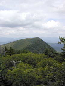
View of Wittenberg. 2001 [HERB CHONG]
6.90 Reach the col between Cornell and Wittenberg Mountains. To the right, a faint old trail leads down extremely steeply to Moon Haw Road in Maltby Hollow. This trail should be avoided by all but the most experienced hikers. The Long Path now begins its climb to the summit of Wittenberg Mountain.
7.25 Reach the summit of Wittenberg Mountain, with a large open rock ledge that affords a tremendous view to the east. The Ashokan Reservoir is visible down below, with Ashokan High Point beyond. On a clear day, the Hudson River may be seen in the distance, with the Taconic Mountains at the Connecticut-Massachusetts border far beyond. To the north, the Devil's Path range is visible. The trail begins a steep descent over a series of rock ledges, continuing through the characteristic spruce-balsam summit forest.
8.15 The Long Path begins to level off and now follows a trail that was constructed by the CCC. It passes through a high elevation deciduous forest.
8.40 The Long Path reaches the end of this section, and turns right on a blue-blazed trail. This new 9-mile section opened in 2014 and is a continuation of the Phoenicia-East Branch Trail. The Wittenberg-Cornell-Slide Trail continues straight ahead and reaches the Woodland Valley campground in 2.75 miles. The Terrace Mountain lean-to is 1.05 miles ahead.
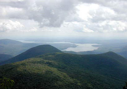
The Ashokan Reservoir from Wittenberg Mountain. 2001 [HERB CHONG]
Previous Section: Section 17
Next Section: Section 19
19. Wittenberg Mountain to Phoenicia
Section 19: Wittenberg Mountain to Phoenicia
Quick Facts
Distance: 9.85 miles
Parks: Slide Mountain Wilderness
Maps: Interactive Map, Catskill Trails (map 142)
Print-Friendly Version: Link
General Description
The Long Path follows a trail along the foot of Wittenberg Mountain and reaches a spectacular viewpoint before descending to Cross Mountain. It is a pleasant hike along Cross Mountain, which is nothing more than a long ridge connecting Wittenberg Mountain with Mount Pleasant. There are several good views of Wittenberg and the Ashokan Reservoir along the way. The trail then passes over Mount Pleasant, about a quarter mile west of the summit, with more nice views of Wittenberg Mountain and a view to the east. Following a series of switchbacks, the trail starts ascending Romer Mountain. From the summit of Romer Mountain, it is a three-mile descent before reaching the DEC parking area at the foot of Romer Mountain. The trail continues on local streets east along the Esopus Creek, and crosses the Esopus into the Village of Phoenicia.
Access
Take the New York StateThruway to Exit 19 (Kingston). Follow NY Route 28 west for 23 miles to Phoenicia. Turn right at the first turn to Phoenicia (Bridge Street). Follow Bridge Street to just before the railroad tracks, and turn left onto High Street. Follow High Street and then Woodland Valley Road 6 miles to the Woodland Valley State Campground. It is a 2.75-mile hike from the campground to the Long Path.
Parking
0.00 Woodland Valley State Campground (parking fee charged in season) (42.03576°, -74.36531°). It is 2.75 miles from the parking lot to the Long Path.
9.10 DEC parking area at Lane Street, Phoenicia. (42.07825°, -74.31913°).
9.85 Village of Phoenicia (parking available on Main Street or behind the Phoenicia Pharmacy on NY Route 214).
Camping
0.00 Woodland Valley State Campground (fee charged). It is 2.75 miles from the campground to the Long Path.
0.00 Terrace Mountain Lean-to (1.05 miles from the Long Path on yellow-blazed Terrace Mountain Trail; no water).
9.85 Black Bear Campground, 17 Bridge Street, Phoenicia; Tel. 845-688-7405.
Trail Description
0.00 From the trail junction, the Long Path follows a section of the Phoenicia–East Branch Trail (constructed by volunteers and opened in June 2014) which is blazed with blue DEC markers. The trail passes through an area that is occasionally wet. In about half a mile, the trail crosses a small stream that often has water.
0.85 Another seasonal stream crossing.
1.15 The trail reaches a spectacular viewpoint on the cliffs. Wittenberg Mountain is rising in the back, Panther Mountain is visible, as are the entire northern Catskills, and from a cliff slightly below, the Ashokan Reservoir can be seen. The trail descends steeply after the viewpoint and in about 0.2 mile passes the Grand Staircase, a series of beautiful rock steps. Past the Grand Staircase, the trail reaches the col between Wittenberg and Cross Mountains. The next couple of miles are mostly ridge walking, with several viewpoints near the summit of Cross Mountain.
View of the Devils's Path. 2014 [JAKOB FRANKE]
2.25 A short side trail (currently unmarked) leads to a good viewpoint. In a few hundred feet, when the trail makes a sharp left turn, there is another short side trail (unmarked) straight ahead through a field of ferns to a viewpoint.
2.35 View from the trail of the Ashokan Reservoir and Samuels Point.
2.40 Another side trail (unmarked) to the right leads to a viewpoint.
2.50 The Long Path reaches the summit of Cross Mountain. The trail starts slowly descending and passes over low cliffs and through several open areas where brambles and blueberries can be found. In about 3/4 mile the trail reaches the col between Cross Mountain and Mount Pleasant and passes through a relatively dark and cool forest, until the trail starts ascending again.
4.00 The trail reaches a fine viewpoint to the west, with Wittenberg and Panther Mountains in full view. The trail then veers to the east side of the ridge, passing a seasonal spring in about 0.1 mile.
4.40 A viewpoint to the east is reached. Below, the Route 28 corridor with the Emerson Resort is visible. The trail swings back to the west side of the ridge.
4.70 Another fine view to the west. Past this view, the trail follows the cliff line for a short while, than slowly descends to the col between Mount Pleasant and Romer Mountain. In the next mile, several switchbacks are passed, after which the trail starts to ascend.
5.75 The trail passes another unmarked side trail to a fine viewpoint to the east.
5.90 The trail reaches the summit of Romer Mountain.
6.70 The trail reaches a cliff, with a seasonal view to the west.
7.10 The trail passes through an interesting crevice and keeps descending, following on occasion stretches of old woods roads.
8.20 The trail crosses a wet area on rock slabs installed by one of the volunteer trail crews.
8.30 The trail turns left onto a woods road. To the right, the woods road leads to an old bluestone quarry.
8.55 The trail makes a sharp left turn. Straight ahead is a short side trail to a pipe spring.
9.10 The Long Path reaches a DEC parking lot at the end of Lane Street. The trail continues out of the parking lot on a local street (Lane Street) and turns left.
9.30 The Long Path turns right on High Street, which runs parallel to Esopus Creek. It crosses under NY Route 28 and intersects Bridge Street.
9.65 The Long Path turns left on Bridge Street, crosses the railroad tracks and then Esopus Creek, and enters Phoenicia. Black Bear Campground is off Bridge Street on the right. The railroad tracks, formerly the route of the Ulster and Delaware Railroad, which once brought trainloads of tourists to this portion of the Catskills. Today, Rail Explorers offers railbike rides from Mt. Pleasant to Phoenicia (www.railexplorers.com).
9.85 Reach Main Street in Phoenicia (Ulster County Route 40). To the left is the center of Phoenicia. While just two blocks long, it is well worth the detour. It is the home of several restaurants and a number of antique shops. There is also a grocery and general store for backpackers to resupply, as well as a B&B. To continue on the Long Path, turn right and proceed eastward on Main Street (Ulster County Route 40).
Esopus Creek in Phoenicia. 2012 [JAKOB FRANKE]
Previous Section: Section 18
Next Section: Section 20
20. Phoenicia to Silver Hollow Notch
Section 20: Phoenicia to Silver Hollow Notch
Quick Facts
Distance: 11.5 miles
Parks: Phoenicia-Mt. Tobias Wild Forest
Maps: Interactive Map, Catskill Trails (map 141)
Print-Friendly Version: Link
General Description
The Long Path leaves Phoenicia on public roads, paralleling the Esopus Creek. The trail then climbs up the south side of Tremper Mountain, following an old tote road to the former state fire tower. From there, it heads toward Carl Mountain and circles it to descend to Warner Creek before going over Edgewood Mountain to Silver Hollow Notch. This section begins a long stretch between supply points. From Phoenicia to Palenville is over 40 miles. In this distance, only two roads are crossed. Neither has stores within 4 miles of the crossings. There is an unbridged stream crossing at the 8.25 mile mark (Warner Creek) that is dangerous to impassible at high water.
Access
Take the New York State Thruway to Exit 19 (Kingston). Follow NY Route 28 west for 23 miles to Phoenicia. Turn right at the second turn to Phoenicia (Bridge Street). Follow Bridge Street across the Esopus Creek to Main Street in Phoenicia.
Parking
0.00 Village of Phoenicia (parking available on Main Street or behind the Phoenicia Pharmacy on NY Route 214). (unlocated)
1.30 There is a DEC parking lot on Plank Road (Ulster County Route 40), 0.3 miles south of where the Long Path leaves the road. (42.06599°, -74.30312°)
11.50 There is parking about 1.2 miles from the end of this section, off NY Route 214 near Notch Inn Road. ( 42.14324°, -74.21215°)
Camping
3.15 Baldwin Memorial Lean-to.
4.00 Tremper Mountain Lean-to.
Trail Description
0.00 From the intersection of Bridge Street and Main Street in Phoenicia continue east on Main Street (Ulster County Route 40), following the north side of Esopus Creek. In the spring, the Esopus is filled with white water canoers and kayakers, as well as trout fishermen. The Esopus is one of the most famous trout streams in America. In the summer, the primary recreational use of the creek is by people who ride lazily downstream in inner tubes.
1.30 The Long Path arrives at the unmarked beginning of the old fire warden's road leading up Tremper Mountain on the left. This was the trailhead for the Phoenicia Trail before it was moved 0.3 miles east to a new parking lot in the late 90s. Turn left following the wide road steeply uphill for about 100 yards to a junction with the Phoenicia Trail. Red markers to the right lead 0.3 miles to the parking area on Ulster County Route 40. Continue straight ahead on red markers following the fire warden's road to the abandoned state fire tower. The grade varies between steep and gradual. On the steeper sections, the trail is rocky and eroded. For most of the way, the trail passes through a mixed hardwood and hemlock forest.
2.05 Pass rock ledges on the left.
2.15 Pass a seasonal spring on left, which is reliable in all but the driest times.
2.20 The trail passes an abandoned bluestone quarry on the left. Bluestone mining was once one of the primary industries in the Catskills. As you pass the quarry, you can see the layering that made bluestone an easy mineral to mine. Past the quarry the trail levels off, crosses several woods roads, and begins a series of switchbacks.
2.95 The trail sidehills through a steep slope with rock walls on the right and a steep drop on the left. After a short level stretch, the trail again begins a steep climb.
3.15 A side trail to the right leads to the Baldwin Memorial Lean-to. In another 250 feet, pass an undependable pipe spring 50 feet to the left of the trail.
3.65 After a switchback, the trail climbs to the top of the ridge, and then follows it the rest of the way to the summit. Here the forest is less mature; consequently, there is more undergrowth.
4.00 Pass the Tremper Mountain Lean-to on the left.
4.05 Reach the flat, level summit of Tremper Mountain, with an abandoned state fire tower, formerly used by fire observers with two-way radios. These towers were placed on top of selected mountains in the early 1900s after a series of fires devastated the mountains. More recently, the fire towers have been replaced by aircraft patrols. This fire tower has been restored and is open to the public. To the right of the tower is an open area that affords a view of the Devil's Path when the leaves are down. Continuing past the tower, the Long Path passes through a cleared area and then begins to descend, now following the blue-blazed Warner Creek Trail. It passes through a fairly open forest, with a base of blackberry rambles.
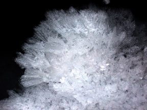
Frost growing from the rocks. 2001 [HERB CHONG]
4.30 The trail enters a more mature forest, with little undergrowth. It continues to descend along the ridge top towards the col between Tremper Mountain and Carl Mountain. Initially, the trail follows the eastern slope of the ridge, with seasonal views through the trees over the Devil's Path to the north.
4.95 The trail levels out and then begins a gradual climb of the north peak of Tremper Mountain. For the most part, the trail stays about 200 vertical feet below the top of the ridge, following the western slopes.
5.80 After passing through a hemlock grove, the trail descends along the eastern side of the ridge.
6.20 Reach the col between Tremper Mountain and Carl Mountain. Here, the yellow-marked Willow Trail turns right, leaving the ridge, descending steeply 1.6 miles through Hoyt Hollow to Jessop Road, and in another mile to the Willow Post Office. Continue ahead on the blue-marked Warner Creek Trail following an old, gently sloping woods road with little elevation change.
6.60 Bear left leaving the woods road and begin a moderate descent through open hardwoods. When the leaves are down, there are views to Tremper Mountain and the Central Catskills beyond.
7.00 The trail eases onto a wide bench and contours to the right around Carl Mountain, slowly gaining elevation.
7.35 Begin a steep descent to Warner Creek, passing a series of cataracts in the seasonal stream to the right of the trail. There are many switchbacks on the way down.
Bluestone quarry. 2011 [JAKOB FRANKE]
7.60 The trail descends some stone steps into the bed of a seasonal stream. Continue across the streambed to meet the terminus of an old quarry road and follow it. In about 0.2 miles, there is a bluestone quarry on the right. Once past the quarry, the trail descends again for a few hundred feet.
7.90 Pass a stone foundation to right. It is in open park-like surroundings and is a perfect area for a campsite. Continue gently downhill towards Warner Creek.
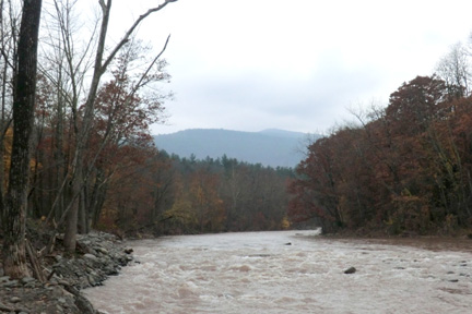
8.25 The trail crosses Warner Creek on a gravel bar in a hemlock grove. There is no bridge for this crossing, making it dangerous at medium or high water.
Warner Creek. 2009 [JAKOB FRANKE]
8.30 Reach a woods road and turn right to follow it. There is a small stream within 500 feet located in a hemlock grove.
8.60 Turn left, leaving the woods road, and begin the climb to the summit of Edgewood Mountain. The ascent is moderate to steep through open hardwoods and an occasional hemlock grove.
9.25 Pass a black birch tree with a large burl in its trunk. Just beyond, the trail joins a faint old quarry road and steepens.
9.55 The trail reaches the broad ridge and turns right to follow it uphill.
10.00 The trail traverses a grassy area.
10.50 Pass a large bog on right.
10.70 The trail crosses the broad summit of Edgewood Mountain. There are no views. Shortly beyond, begin a steep descent through rocky ledges toward Silver Hollow Notch.
11.00 Reach a view into Warner Creek Valley with Olderbark Mountain opposite.
11.20 Reach a view to the south over Warner Creek Valley.
11.50 Arrive at Silver Hollow Notch and the end of Section 20. To continue, cross the road and follow the blue blazes. Turning to the left leads in about a mile to Notch Inn Road and NY Route 214.