15. Port Ben Road to Riggsville

Section 15: Port Ben Road to Riggsville

Alerts

  • This section includes a change in the division point between sections 14 and 15 as of Fall 2023.

Quick Facts

Distance: 11.25 miles
Parks: Vernooy Kill State Forest, Sundown Wild Forest
Maps: Interactive Map, Catskill Trails (map 146)
Print-Friendly Version: Link

General Description

Currently this entire section is on roads, but work is in progress to move it off the roads in connection with a DEC Unit Management Plan for Vernooy Kill State Forest and Sundown Wild Forest. The Long Path starts at the Port Ben Road bridge on the north end of Port Ben, a hamlet in the town of Wawarsing, crossing Rondout Creek and continuing to US Route 209. It follows Route 209 for a short distance, turns north on Lundy Road, then east on Rogue (Rouge) Harbor Road, and then north again on Cherrytown and Upper Cherrytown roads to Riggsville. Although this is currently a roadwalk, there are many fine views and interesting features along the way, and vehicular traffic volume is low on most of the roads.

Access

Take the New York State Thruway to Exit 19 near Kingston, then take NY Route 209 west through Kerhonkson, to Wawarsing. In Wawarsing, immediately after crossing the Vernooy Kill, turn left on Port Ben Road, and follow it 0.7 to the bridge that is closed to vehicles.  A parking area on state land is on the left (north) side of the road just prior to the bridge.

Camping

On DEC land.

Parking

0.00  Parking area on state land on the north side of the bridge. (41.75082°, -74.35076°)
2.20  DEC parking lot on Cutler Road. (41.76764°, -74.37148°)
11.25  DEC parking lot on Upper Cherrytown Road. (41.86422°, -74.34615°)

Trail Description

0.00  The Long Path crosses the Port Ben Road bridge across the Rondout Creek, which is now closed to vehicles but is open for pedestrians. A parking area is at the northern end of the bridge. For the next 0.3 mile along Port Ben Road, open farm fields provide great views on both sides of the road.

0.70  Turn right onto US Route 209 and cross the Vernooy Kill. The Wawarsing post office is on the right, next to the stream.

0.80  Turn left onto Lundy Road. Be careful, as Route 209 is a very busy road and oncoming west-bound traffic is coming from a curve.

1.20  Pass the last house on the left. The Vernooy Kill is on the left (south) side of the road.

1.30  DEC land starts on the right. In the next half mile, there are a dam and rapids in the Vernooy Kill and opportunities for swimming. Both Lundy Road and upcoming Rogue (Rouge) Harbor Road are very low traffic roads.

2.20  Cutler Road on the left crosses the stream, with a large DEC parking lot on the west side of the bridge. Future plans are to have the Long Path cross the Vernooy Kill here and then proceed north to Vernooy Falls instead of the roadwalk.

2.55  Pass the first of two old homestead sites on the left. The second site is located 500 feet further on the left.

3.05  Turn right onto Rogue (Rouge) Harbor Road (unpaved). The property on the south side of the road is privately owned.

3.35  A large fence appears on the right (south) side of the road.

3.75  The end of the fence.

3.95  DEC land starts on the left (north) side of the road.

4.30  DEC land now is on both sides of the road.

4.55  A tree on the left contains an old sign (facing east) pointing south to Turner Cemetery. About 300 feet off the road, just to the east of a stone wall, are two head stones.
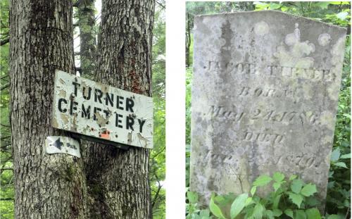
Turner cemetery off Rogue Harbor Road. 2011 [JAKOB FRANKE]

4.75  A DEC parking lot is on the left (north) side of the road.

5.05  End of the DEC lands.

5.35  J&J Road on the right. Rogue (Rouge) Harbor Road becomes paved.

5.70  Woodland Ridge Road on the right. Vehicle traffic may increase.

6.00  The end of Rogue (Rouge) Harbor Road. Turn left onto Cherrytown Road.

7.00  Pass Mt. Laurel Road on the left, continue straight on Cherrytown Road.

8.10  Pass Baker Road on the left.

8.20  Turn left onto Upper Cherrytown Road where Cherrytown Road ends. As it makes the turn, houses are on the left and an old building with garages is on the right.

9.55  Pass White Birch Lane (unpaved private road) on the left, and cross the unsigned Catskill Park boundary.

11.25  The section ends at a DEC parking area on the right side of the road. To continue, turn left and enter the woods on the red-blazed Vernooy Kill Falls Trail.


Previous Section: Section 14
Next Section: Section 16

Comment: Please be relevant, civil, non-commercial.

Gedalyamil's picture

Today was memorable. We will never forget it. A blissful morning turned into a cursed evening, until we were rescued. I parked at the Berme Road pullout for the start on Stage 15. My daughter Julia joined me. We left our home in NJ at 8:45 and were ready to hike by 10:30. This was the 3rd leg of the LP that Julia has joined me for. She has special needs. Have you noticed that a high proportion of special needs kids are overweight? I know they may have a slower metabolism, etc. However, sometimes I feel like so little is expected of them. The physical fitness bar is set too low. Julia walked the 12.3 miles quite easily. Yes, I picked this hike which was a road walk, but she could've done the Devil's Path too. Anyway, I just saying that special needs kids can do more than a walk around the block and hiking is a great sport to develop motor skills and confidence while opening up a new world just like it does for able folks. I really liked this hike!! I applaud the NY/NJ trail Conference for trying to get Stage 15 off road, but I didn't feel cheated one bit. The start of the hike along the Rondout Creek was lovely! Port Ben Road felt remote, the surrounding fields were fresh and open, and crossing the bridge over the Creek was an adventure as we had to crawl under the blockades. Julia and I felt like escaped criminals on the bridge. I'm not sure it's even open to pedestrians, but nobody arrested us. Lundy Road required some climbing, but also sported anglers decked in hip boots in the adjacent Vernooy Kill. Rouge Harbor Road was a classic Catskills unpaved woods road. I wonder who lives in the elaborate fenced estate. Its either rich people or government or both. Cherrytown Road, both upper and lower, were postcard bucolic!! Beautiful farms, cows, horses, both red and rustic barns. Julia and I strolled into the DEC Parking Lot at the Vernooy Falls Trailhead just past 4:30PM. The day was pleasant, but it had just started getting colder and flurrying snow. I had reserved a cab mid-hike and then called again 30 minutes before our finish. We didn't actually leave until nearly 4 hours later. The taxi driver from Ellenville wasn't able to get moving until 5:30, but he never arrived. I had no internet reception and didn't speak gibberish so I called my brother and asked him to please try to direct the cabbie by phone. My brother sent him our coordinates on Google Maps and directed him as best he could in Giberlish for 45 minutes. The message simple: drive up Upper Cherrytown Road (just 5 miles!!) and look for 2 shivering people. To no avail, it was unadulterated frustration. It was nearing 7PM and sunset. At the same time, I was dealing with considerable turmoil on the home-front. My wife was accusing me of daughter endangerment and my mother-in-law was egging her on. Between the mother, grandmother, and the cabbie from hell I was in a tough spot. Finally, my brother heroically drove from Callicoon, NY for 80 minutes to fetch us. Simultaneously, my son called Busy Bee cab company in Wurtsboro to save us. They both arrived at precisely the same time. The female cabbie in an old fashioned London-style taxi car and my brother in his Kids' Tesla. He even brought us food and drink. What a great brother!! We took the bananas, but drove back in the cab at 8:15PM because we owed her for the trip. I regretted bringing my brother back to this spot. Turns out there is something very spooky about Vernooy Falls for him. In 1995 his wife (my sister-in-law) signed a pre-nup that she would agree to hike once a year. That worked fine until circa 2002 when they took my niece baby Tami hiking in a brand new Kelty Baby Carrier at Vernooy Falls Trailhead. It was a perfectly azure sky blue day. Suddenly, rain, crying baby, and sister-in-law swears off hiking for life. And she hasn't hiked since! When Julia and I arrived home at 10:30, I went straight to fill in my daily LP tally sheet. Then I noticed, it was April Fools Day! Regardless, I had ambitious plans to complete the LP within the next month. I'll have to sort out some of the logistical issues. Taxi services are scarce in Catskill Park, and phone and internet can be sketchy. My general plan: park at the terminus, rather than the start, and take a pre-scheduled taxi to the starting point in the morning. You can't always rely on Elijah showing up in the mountains.
srtmaintainer's picture

Hi George, I am the Chair of the Long Path. Thanks for your trip reports, glad your enjoying the trail. I always advise everyone to leave their car at the end of the hike and get a ride to the beginning. The next two sections are tough for getting a cab. When do you plan to do 16?
Gedalyamil's picture

Thanks! I took your advice and have been doing exactly what you said: "leave their car at the end of the hike and get a ride to the beginning". It may be tough in the Northern Catskill section b/c it's not served well by taxi companies, but if I cant arrange one my wife offered to drive me. Thanks, george