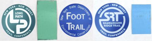
The Long Path is marked with a 2" x 4" paint blaze for most of the route. The blaze color is LP aqua, a trade name of the New York-New Jersey Trail Conference. It is a light blue-green that many people term turquoise. Turns are marked with two blazes, one over the other, with the top blaze offset in the direction of the turn. For important locations, the Long Path uses plastic marker disks (often abbreviated to "markers") that approximate the paint blaze color. The SRT is marked with 2"x3" blue paint blazes, and blue markers at some locations.
The only major exceptions to the blazing described above are in Catskill Park and on the Wurtsboro Ridge DEC parcels near Wurtsboro on the Shawangunk Ridge. These are areas where the Trail Conference maintains the trails on behalf of the DEC. In the both areas, the Long Path follows existing Forest Preserve trails marked in blue, red, or yellow plastic disks, depending upon the trail. In certain sections of private land inside the park, the Long Path blazes revert to aqua paint blazes. In the oldest parts of the park, some of these markers are made of painted metal. Be sure to read the descriptions carefully, as the disk colors often change in the middle of a section.
Three main sources of maps cover the areas traversed by the Long Path: ones produced by the New York-New Jersey Trail Conference, ones produced by the United States Geological Survey (USGS), and by Jimapco, a commercial map vendor. The Trail Conference's maps are specialized for hiking. They contain all of the officially maintained trails in their areas of coverage with markings for features of special interest to hikers. The maps are printed on Tyvek, a waterproof and tear resistant material, to enable their use in all weather conditions. However, only about half of the Long Path crosses areas covered by these maps. The USGS 7.5' 1:24,000 series of topographic map quads cover all areas crossed by the Long Path but are printed on paper and thus need protection from wet and windy weather. Also, the vast majority of these maps were produced in the 1950s or 60s and are sometimes well out of date, even when taking into account special "photo-revised" updates produced in the early 1980s. The third source is Jimapco, a company specialized in making road maps of the northern part of the Hudson Valley and surrounding areas. They produce the best road maps available for navigating to and from the trailheads for each of the sections of the Long Path. Jimapco maps are available at many small stores from Orange County northwards or on the web at http://www.jimapco.com.
The maps in this book are a combination of USGS data with some corrections to areas important for navigating the Long Path. They are designed to be a supplement to the Trail Conference's hiking maps and the USGS topographic maps. As such, they are neither as detailed nor as complete in coverage. However, they do contain enough detail so that hikers will not need to continually reference other maps in order to navigate the trail as they follow the descriptions in this guide.
Modern technology has become a useful accessory to hikers with small, hand-held Global Positioning System (GPS) units now being quite inexpensive and reliable. The trail section descriptions contain GPS coordinates to aid in navigating the Long Path and allow hikers to reliably place themselves relative to the important points on the trail. This includes all of the major named features and all of the official parking areas.
Each GPS coordinate in this book is given in Universal Transverse Mercator (UTM), a worldwide standard for specifying a location on the Earth. UTM has become popular among GPS users because the coordinates are north and east specifications in meters. Knowing the UTM coordinates for two positions allows one to easily estimate the distance between the positions.
One caveat of using a GPS for navigation is that there are many different references for specifying a position. Nearly all United States Geological Survey (USGS) topographic maps are referenced to NAD27 while all GPS units in this country come from the factory set to NAD83/WGS84 (the later two standards are identical for practical use in North America). All of the coordinates in this book are given using the NAD83/WGS84 standards. In the area covered by the Long Path, the difference in position using a given coordinate amounts to several hundred feet when switching between NAD27 and NAD83/WGS84.
The second caveat for using a GPS for navigation is that there is an inherent error in GPS positions that depend on the satellite configuration and signal reception conditions at the time of measurement. Although under ideal conditions, a consumer GPS unit can be as accurate as ten feet, more typically twenty to fifty feet is the norm. The GPS positions in the descriptions in this book specify location information to more precision than the accuracy allows. This means that using a GPS unit to move to the position exactly as stated in the trail descriptions in this book will place one very close to the intended point, but not necessarily closer than one hundred feet, depending on conditions.
A third caveat for GPS users is that USGS topographic maps can contain systematic positional errors. Some of the older maps were completed from aerial photographs taken during World War II. These include many of the quads required to obtain coverage of the Long Path, and can have average horizontal errors of as much as 200 feet compared to a GPS or recent aerial photographs of the same area.
Thus, although a GPS unit can be very precise for navigation, it may not correspond to topographic or any other map sources based only on USGS data.