Section 18: Denning Road to Wittenberg Mountain
Quick Facts
Distance: 8.4 miles
Parks: Slide Mountain Wilderness
Maps: Interactive Map, Catskill Trails (map 143)
Print-Friendly Version: Link
General Description
From the valley of the East Branch of the Neversink River, the Long Path follows the route of the Phoenicia-East Branch Trail. At the Curtis Monument, it turns onto the ridge of the Burroughs Range. Slide Mountain, the first encountered on the ridge, is the highest peak in the Catskills. The trail then passes over Cornell and Wittenberg Mountains. Since the Long Path in this section follows several DEC trails, the hiker should be careful at trail junctions to choose the correct trail.
Access
From New York City: Take the New York State Thruway to Exit 16 (Harriman). Continue on NY Route 17 west to Exit 100 (Liberty). Turn right at the end of the exit ramp and follow NY Route 55 east for 10 miles to Curry. At a sign on the right for Claryville, turn left onto Sullivan County Route 19 (Claryville Road) and follow it for 13 miles to the trailhead at the end of the road. The name of the road changes to Denning Road upon reaching Claryville. After about 7.5 miles, the designation of the road as a county road ends, and the road narrows. To reach the beginning of this section of the Long Path, follow the Phoenicia-East Branch Trail northeast from the parking area for 1.2 miles.
From the Hudson Valley: Take the New York State Thruway to Exit 18 (New Paltz). Continue west on NY Route 299 through the Village of New Paltz. At the junction with US Route 44/55, go west (right). Follow Route 55 to Curry, and make a right onto Sullivan County Route 19. Continue as described above.
Parking
0.00 Parking area at end of Denning Road (1.2 miles along the Phoenicia-East Branch Trail from the beginning of this section) (41.96556°, -74.45248°).
8.40 Woodland Valley State Campground (parking fee charged in season) (42.03576°, -74.36531). It is 2.75 miles along the Wittenberg-Cornell-Slide Trail (also called Burroughs Range Trail) from the Long Path to the campground.
Camping
Several campsites in this section at 1.75 mi, 5.00 mi, and 5.25-5.50 mi.
8.40 Terrace Mountain Lean-to (1.05 miles from the Long Path on yellow-blazed Terrace Mountain Trail; no water), and Woodland Valley State Campground (fee charged), 2.75 miles from the Long Path.
Trail Description
0.00 From the intersection of the Peekamoose-Table Trail with the Phoenicia-East Branch Trail (it is 1.2 mi from Denning Road to this intersection) proceed north on the yellow-blazed Phoenicia-East Branch Trail (a woods road). The trail rises gently but steadily through hardwood forest, crossing a few small streams.
0.55 Pass a spring to the left of the trail.
0.85 Cross a stream on a wooden bridge. The trail runs along the shoulder of a steep slope, with the rushing water of Deer Shanty Brook below to the right.
1.75 Turn right onto the blue-blazed Curtis-Ormsbee Trail. The yellow-blazed Phoenicia-East Branch Trail continues straight ahead, reaching Ulster County Route 47 in 1.5 miles. Near the junction is a DEC campsite, and a stone monument in memory of William ("Father Bill") Curtis and Allen Ormsbee, both of whom died in a snowstorm on Mt. Washington on June 30, 1900. The trail is named in their memory. The Curtis-Ormsbee Trail leads up the ridge of the Burroughs Range, which comes into view just before the trail junction. The ascent is sometimes steeply up rock ledges, and alternates between hardwood and spruce forest.
2.40 About 500 feet past the sign marking the 3,500-foot elevation, a short side trail leads right, to a ledge with a spectacular lookout. Table Mountain (with its long, flat top) and Rocky and Lone Mountains are clearly visible. The ascent continues, with level, swampy stretches and steep climbs.
3.40 Turn right onto the red-blazed Wittenberg-Cornell-Slide Trail. The trail ascends gently through dense spruce trees.
4.05 Reach the summit of Slide Mountain (marked by a concrete slab, a remnant of a former fire tower). At 4,180 feet in elevation, this is the highest point in the Catskill Mountains. In another 300 feet, an outcrop on the left side of the trail offers an excellent view to the east, with the Ashokan Reservoir visible below in the distance. The Burroughs Plaque, commemorating John Burroughs, is set into the side of this outcrop. The descent from Slide is steep and rugged, with wooden steps provided in the steepest section. Several good views are possible along the way.
4.30 A sign marks the way to a spring, a dependable source of water, on the left side of the trail. The pitch of the descent becomes more moderate, but several sharp rock faces must be traversed.
5.00 Reach the low spot between Slide and Cornell Mountains. An unmarked trail leads right, about 300 feet to a spring. This is a popular camping spot for those doing the Wittenberg-Cornell-Slide circular, but reports indicate it may be trashy. Beyond the col, the trail levels off and passes around a wet area. In the spring, the hobblebush puts on a spectacular show in this area. The trail begins to ascend Cornell Mountain, passing through a dense spruce-balsam forest. As the trail nears the summit of Cornell, it climbs steeply over a series of rock ledges.
5.25 There are at least 4 decent campsites in the next quarter mile.
6.25 Reach the top of a rock ledge. To the left of the trail is a rock outcropping with a spectacular view of the great Panther-Slide Wilderness Area, the largest unbroken landmass in the Catskills. Views of Slide Mountain and its slide are directly ahead. To the left, Peekamoose, Table, Lone and Rocky Mountains are visible. To the right of Slide are Giant Ledge and Panther Mountain, with the Devil's Path range in the far distance. From this viewpoint, there is no evidence of civilization in the Catskills.
6.45 To the right, a short yellow-blazed side trail leads to the summit of Cornell Mountain. The view from Cornell is somewhat overgrown, but there are good views eastward to the Ashokan Reservoir. From here, the trail begins to descend.
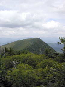
6.55 The trail reaches the top of a rock ledge, with a view to the northwest toward Wittenberg Mountain. The trail scrambles down a very steep crevice in the rock ledge and onto the "Bruin's Causeway", the path along the ridge between Cornell and Wittenberg. This is one of the highest cols in the Catskills, with the elevation remaining over 3,500 feet.

View of Wittenberg. 2001 [HERB CHONG]
6.90 Reach the col between Cornell and Wittenberg Mountains. To the right, a faint old trail leads down extremely steeply to Moon Haw Road in Maltby Hollow. This trail should be avoided by all but the most experienced hikers. The Long Path now begins its climb to the summit of Wittenberg Mountain.
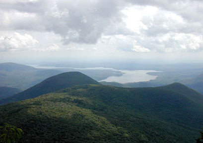
7.25 Reach the summit of Wittenberg Mountain, with a large open rock ledge that affords a tremendous view to the east. The Ashokan Reservoir is visible down below, with Ashokan High Point beyond. On a clear day, the Hudson River may be seen in the distance, with the Taconic Mountains at the Connecticut-Massachusetts border far beyond. To the north, the Devil's Path range is visible. The trail begins a steep descent over a series of rock ledges, continuing through the characteristic spruce-balsam summit forest.
8.15 The Long Path begins to level off and now follows a trail that was constructed by the CCC. It passes through a high elevation deciduous forest.
8.40 The Long Path reaches the end of this section, and turns right on a blue-blazed trail. This new 9-mile section opened in 2014 and is a continuation of the Phoenicia-East Branch Trail. The Wittenberg-Cornell-Slide Trail continues straight ahead and reaches the Woodland Valley campground in 2.75 miles. The Terrace Mountain lean-to is 1.05 miles ahead.

The Ashokan Reservoir from Wittenberg Mountain. 2001 [HERB CHONG]

Comment: Please be relevant, civil, non-commercial.
GM's Day 18 of Long Path