From the northern end of the parking area, cross to the east side of Skyline Drive and find a triple purple-on-white blaze, which marks the start of the Tamarack Loop, on a telephone pole. Turn right and follow the Tamarack Loop south for 200 feet along Skyline Drive, then turn left and enter the woods. Continue along the trail as it winds downhill on a rocky footpath and then ascends from a...
Hike Description:
From the northern end of the parking area, cross to the east side of Skyline Drive and find a triple purple-on-white blaze, which marks the start of the Tamarack Loop, on a telephone pole. Turn right and follow the Tamarack Loop south for 200 feet along Skyline Drive, then turn left and enter the woods. Continue along the trail as it winds downhill on a rocky footpath and then ascends from a shallow ravine.
In half a mile, the trail turns right onto a woods road, which almost immediately curves to the left. Just beyond, the green-on-white-blazed Todd Hill Loop comes in from the right, and both trails run jointly for a short distance. At a sign for the Todd Hill Loop, turn left, leaving the woods road, and continue to follow the purple-on-white-blazed Tamarack Loop, which heads north on a footpath.
Soon, the Tamarack Loop reaches Todd Lake. The trail follows along the west shore of the lake, passing a rock ledge at lake level with a view over the lake (covered in the summer with water lilies). It then climbs away from the lake and bears left, passing cliffs on the right. Just ahead, the Tamarack Loop turns left, but you should turn right, now following the Yellow Trail (blazed with yellow diamonds), which begins here. The Yellow Trail climbs steeply, then descends steadily to a valley. After going down a rather steep section, the trail crosses a stream on rocks. It bears right, parallels the stream for a short distance, then descends a little more to cross another stream by a small cascade (this stream may be dry if it hasn’t rained lately).
The Yellow Trail turns left, goes under a fallen tree, and begins a steady climb. On the way up, you’ll pass an old stone wall on the right. The trail eventually levels off on a shoulder of the ridge, with glimpses through the trees of Campgaw Mountain to the east.
About two miles from the start of the hike, you’ll reach a fork. Continue on the Yellow Trail, now joined by the white-blazed Millstone Trail. Just beyond the junction, several abandoned millstones in various stages of completion may be seen on the right. This area was once the site of a millstone quarry, and the stones that you see were either damaged during quarrying or abandoned when the operation shut down. One millstone is in nearly perfect condition. This is a good spot to take a break.
Now go back to the fork and bear right, following the white blazes of the Millstone Trail. After climbing a little more, you’ll reach an open area at the crest of the rise, with a huge boulder balanced on several smaller rocks to the right. To the left, there are several patches of prickly pear cactus, which blooms in early July. This is the only native cactus found in northeast United States.
After a brief descent, the trail climbs to the top of Millstone Hill, where there is a viewpoint to the southwest. It then descends, passing to the right of a huge boulder known as “Sitting Hen Rock.” At the base of the descent, the trail turns right and goes through “Rocky Slide Gulch,” a shallow notch. Just beyond, the Millstone Trail crosses the orange-blazed Schuber Trail.
The Millstone Trail now bears right and goes along the edge of the Azalea Swamp. It climbs out of the swamp and soon turns right onto a grassy woods road, beginning a steady descent. After passing a wooden latrine and an interesting rock formation on the right, the trail reaches the Explorer Cabin of Camp Glen Gray. Here, the Schuber Trail briefly joins. (Camp Glen Gray is owned by Bergen County and managed by the Friends of Glen Gray. Cabins and other camp facilities may be rented by interested parties. (201) 327-7234; www.glengray.org.)
Just beyond, you’ll reach the shore of Lake Vreeland. Turn left here, leaving the Millstone Trail, and follow the orange blazes of the Schuber Trail. You’ll go by the Mothers’ Pavilion along the lake shore and head uphill, passing several camp buildings. Just beyond the Gilwell campsite (on the right side of the trail), you’ll notice three red-on-white blazes on a tree, which mark the start of the Matapan Rock Trail.
At a sign for “Ramapo/Troop 12,” turn left onto the Matapan Rock Trail, which heads uphill on a woods road. Be alert for a left turn, where the trail leaves the road, heads uphill on a footpath, then turns left to rejoin the road. When you reach a wide grassy swath – the route of a gas pipeline – turn left, then immediately bear right and cross the grassy swath diagonally. A red-on-white blaze should be visible at the opposite edge of the grassy swath.
At the crest of the rise, you’ll cross a gravel road and then the Hoeferlin Memorial/Cannonball Trail, marked with yellow and white-C-on-red blazes. Continue straight ahead to the end of the Matapan Rock Trail at Matapan Rock, a rock ledge which affords an expansive view to the west. You can hear the sounds of the traffic on Skyline Drive, directly below, but in the summer, the vegetation largely obscures your view of the road. After enjoying the view, retrace your steps to the crossing of the Hoeferlin Memorial/Cannonball Trail. Turn right and proceed south along the joint Hoeferlin Memorial/Cannonball Trail, which goes through dense mountain laurel thickets.
In another third of a mile, the trails descend on switchbacks to cross a gas pipeline adjacent to Skyline Drive. Just beyond the pipeline, they bear left and re-enter the woods, soon crossing the inlet of a wetland. About half a mile beyond, the yellow-blazed Hoeferlin Memorial Trail leaves to the left, but you should continue ahead on the white-C-on-red-blazed Cannonball Trail.
Just ahead, follow the Cannonball Trail as it crosses Skyline Drive (use care crossing this busy road) and continues along a paved road. Here, the white-blazed Castle Loop joins from the right. The joint trails follow the road for 200 feet, then turn left onto a footpath through the woods. Soon, you’ll reach a junction where the two trails diverge. Turn left and follow the white-blazed Castle Loop along a footpath roughly parallel to Skyline Drive until you reach the parking area where the hike began.
Publication: Submitted by Daniel Chazin on 07/01/2005 updated/verified on 10/27/2022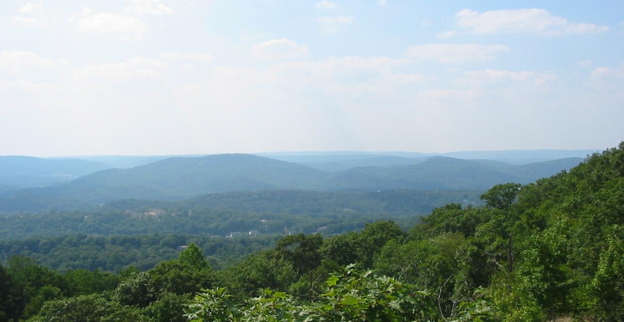

This loop hike passes interesting and historic millstones, goes by two scenic lakes and climbs to a panoramic viewpoint.
41.047479, -74.251313
Bergen Co., NJ
6 mi
4 hrs

Avenza App Map: Northern New Jersey Highlands 150
Hike Checklist:
Whether you are going for a day hike or backpacking overnight, it is good practice to carry what we call The Hiking Essentials. These essentials will help you enjoy your outing more and will provide basic safety gear if needed. There may also be more essentials, depending on the season and your needs.
The Essentials
Hiking Shoes or Boots
Water - Two quarts per person is recommended in every season. Keep in mind that fluid loss is heightened in winter as well as summer. Don't put yourself in the position of having to end your hike early because you have run out of water.
Map - Know where you are and where you are going. Many of our hiking areas feature interconnecting network of trails. Use a waterproof/tear-resistant Tyvek Trail Conference map if available or enclose your map in a Ziplock plastic bag. If you have a mobile device, download Avenza’s free PDF Maps app and grab some GPS-enhanced Trail Conference maps (a backup Tyvek or paper version of the map is good to have just in case your batteries die or you don't have service). Check out some map-reading basics here.
Food - Snacks/lunch will keep you going as you burn energy walking or climbing. Nuts, seeds, and chocolate are favorites on the trail.
Sunscreen and insect repellent
Rain Gear and Extra Clothing - Rain happens. So does cold. Be prepared for changing weather. Avoid cotton--it traps water against your skin and is slow to dry. If you are wearing wet cotton and must return to your starting point, you risk getting chills that may lead to a dangerous hypothermia. Choose synthetic shirts, sweaters and/or vests and dress in layers for easy on and off.
Compass - A simple compass is all you need to orient you and your map to magnetic north.
Light - A flashlight or small, lightweight headlamp will be welcome gear if you find yourself still on the trail when darkness falls. Check the batteries before you start out and have extras in your pack.
First Aid Kit - Keep it simple, compact, and weatherproof. Know how to use the basic components.
Firestarter and Matches - In an emergency, you may need to keep yourself or someone else warm until help arrives. A firestarter (this could be as simple as leftover birthday candles that are kept inside a waterproof container) and matches (again, make sure to keep them in a waterproof container) could save a life.
Knife or Multi-tool - You may need to cut a piece of moleskin to put over a blister, repair a piece of broken equipment, or solve some other unexpected problem.
Emergency Numbers - Know the emergency numbers for the area you're going to and realize that in many locations--especially mountainous ones, your phone will not get reception.
Common Sense - Pay attention to your environment, your energy, and the condition of your companions. Has the weather turned rainy? Is daylight fading? Did you drink all your water? Did your companion fail to bring rain gear? Are you getting tired? Keep in mind that until you turn around you are (typically) only half-way to completing your hike--you must still get back to where you started from! (Exceptions are loop hikes.)
Check the weather forecast before you head out. Know the rules and regulations of the area.
The Leave No Trace Seven Principles
Plan Ahead and Prepare
- Know the regulations and special concerns for the area you'll visit.
- Prepare for extreme weather, hazards, and emergencies.
- Schedule your trip to avoid times of high use.
- Visit in small groups when possible. Consider splitting larger groups into smaller groups.
- Repackage food to minimize waste.
- Use a map and compass to eliminate the use of marking paint, rock cairns or flagging.
Travel and Camp on Durable Surfaces
- Durable surfaces include established trails and campsites, rock, gravel, dry grasses or snow.
- Protect riparian areas by camping at least 200 feet from lakes and streams.
- Good campsites are found, not made. Altering a site is not necessary.
- In popular areas:
- Concentrate use on existing trails and campsites.
- Walk single file in the middle of the trail, even when wet or muddy.
- Keep campsites small. Focus activity in areas where vegetation is absent.
- In pristine areas:
- Disperse use to prevent the creation of campsites and trails.
- Avoid places where impacts are just beginning.
- Pack it in, pack it out. Inspect your campsite and rest areas for trash or spilled foods. Pack out all trash, leftover food and litter.
- Deposit solid human waste in catholes dug 6 to 8 inches deep, at least 200 feet from water, camp and trails. Cover and disguise the cathole when finished.
- Pack out toilet paper and hygiene products.
- To wash yourself or your dishes, carry water 200 feet away from streams or lakes and use small amounts of biodegradable soap. Scatter strained dishwater.
- Preserve the past: examine, but do not touch cultural or historic structures and artifacts.
- Leave rocks, plants and other natural objects as you find them.
- Avoid introducing or transporting non-native species.
- Do not build structures, furniture, or dig trenches.
- Campfires can cause lasting impacts to the backcountry. Use a lightweight stove for cooking and enjoy a candle lantern for light.
- Where fires are permitted, use established fire rings, fire pans, or mound fires.
- Keep fires small. Only use sticks from the ground that can be broken by hand.
- Burn all wood and coals to ash, put out campfires completely, then scatter cool ashes.
- Observe wildlife from a distance. Do not follow or approach them.
- Never feed animals. Feeding wildlife damages their health, alters natural behaviors, and exposes them to predators and other dangers.
- Protect wildlife and your food by storing rations and trash securely.
- Control pets at all times, or leave them at home.
- Avoid wildlife during sensitive times: mating, nesting, raising young, or winter.
Be Considerate of Other Visitors
- Respect other visitors and protect the quality of their experience.
- Be courteous. Yield to other users on the trail.
- Step to the downhill side of the trail when encountering pack stock.
- Take breaks and camp away from trails and other visitors.
- Let nature's sounds prevail. Avoid loud voices and noises.
The Trail Conference is a 2015 Leave No Trace partner.
(c) Leave No Trace Center for Outdoor Ethics: www.LNT.org.
Directions to Trailhead :
Take I-287 to Exit 57 (Skyline Drive) and proceed north on Skyline Drive for a little over a mile to the upper parking area for Ramapo Mountain State Forest on the left side of the road at milepost 1.4.
TRAIN TRANSPORT :
Not availableBUS TRANSPORT :
Not availableShare Your Experience

SUPPORT
 Support the trails with a donation!
Trail Conference volunteers maintain trails in this hike.
Trip Reports
rate experience February 05, 2017
One place requires attention...
About a half mile from the start, the White Trail turns right onto a woods road. Daniel Chazin's description is accurate, but the turn is not well-marked. Likewise, the turn shortly thereafter onto the Yellow Trail is easy to miss. If you come to a rocky outcrop with a nice view to the south and west, you've gone too far on the White Trail.
The only negative for this walk is that the last mile, on the Yellow Trail, is near Skyline Drive. The traffic noise detracts from the walk.
It's Super Bowl Sunday and puppy and I saw not even one other person.