From the parking area, cross Skyline Drive. You will see a triple purple-on-white blaze on a tree, which marks the start of the Tamarack Loop. Turn right onto the gravel road that leads into Camp Tamarack, then immediately turn left and follow the purple-on-white blazes downhill on a winding footpath. At the base of the descent, turn right at a T-intersection, then bear left, skirting the...
Hike Description:
From the parking area, cross Skyline Drive. You will see a triple purple-on-white blaze on a tree, which marks the start of the Tamarack Loop. Turn right onto the gravel road that leads into Camp Tamarack, then immediately turn left and follow the purple-on-white blazes downhill on a winding footpath. At the base of the descent, turn right at a T-intersection, then bear left, skirting the ruins of the former rifle range of the camp. Here, the Tamarack Loop turns right, but you should continue straight ahead, now following the orange blazes of the Schuber Trail. The Schuber Trail crosses a stream on a wooden footbridge, climbs over a knoll and descends to cross a second stream.
About half an hour into the hike, you’ll reach a junction with the white-blazed Millstone Trail. Turn right onto the Millstone Trail, which climbs to Rocky Slide Gulch, where it turns right, then curves left and continues to climb. After a relatively level section, it passes to the left of a huge boulder known as “Sitting Hen Rock” (marked by a sign “HT10"), then bears right and resumes its ascent. Just beyond the crest of the hill, the trail reaches the Southwest Lookout.
From the lookout, the Millstone Trail bears left, descends slightly, then climbs to reach a balanced rock in an open area. Again, the trail bears left and descends. Soon, the Yellow Trail (blazed with yellow diamonds) joins from the right, and both trails pass several abandoned millstones in various stages of completion. This area was once the site of a millstone quarry, and the stones that you see were either damaged during quarrying or abandoned when the quarry operation shut down.
The yellow and white trails continue to descend on a winding footpath, crossing a woods road along the way (marked by a sign “HT12"). Just beyond, a millstone in nearly perfect condition may be seen to the right of the trail. Near the base of the descent, the trails cross another woods road and pass an old stone wall on the right.
The trails cross paved Midvale Mountain Road at Kiosk #4 and reenter the woods. They bear left and head west, parallel to Fox Brook, then turn right to cross two branches of the brook on wooden bridges. The trails now begin to climb, reaching a junction in a level area. Here, the Millstone Trail leaves to the left, but you should turn right, staying on the Yellow Trail. The trail briefly follows an old woods road, then turns left, passing a huge, flat-sided boulder, and heads north, climbing steadily through a wooded valley.
After reaching the crest of the rise, the trail descends briefly and continues along a level woods road. It crosses a stream on a wooden bridge and, just beyond, passes the stone foundations of some old Scout buildings and ruins of an older foundry. Just ahead, it turns right onto a wide woods road (briefly joining the route of the Yellow-Silver Trail). In 100 feet, it reaches the rusted frame of an old water tower. Follow the Yellow Trail as it turns left and begins to ascend, soon passing a stone foundation on a rock ledge.
At the high point of the ridge (996 feet), marked by a post with a sign “HT2,” the orange-blazed Schuber Trail comes in from the left. Here, from a rock outcrop to the right of the trail, is an expansive viewpoint over northern Bergen County. On a clear day, you can see the Manhattan skyline on the horizon to the right. This high point, known as Twin Hill, is a good place to stop and take a break.
When you’re ready to continue, turn right and head north along the ridge on the joint orange and yellow trails, which begin a steady descent. Soon, you’ll notice three green-tulip-tree-leaf-on-white blazes on a post to the left of the trail. They mark the start of the Old Guard Trail. This trail – blazed in 2003 by volunteers of the New York-New Jersey Trail Conference – follows the routes of several historic Scout trails and loops around the Northwest Quadrant of Camp Glen Gray.
Turn left and proceed along the Old Guard Trail, which first traverses a level area, then climbs a little. After descending steadily along a woods road to cross a small stream, it begins a steady ascent, passing interesting cliffs along the way. At the crest of the rise, the trail crosses the route of a gas pipeline. The trail descends steeply from the pipeline and continues to descend more gradually.
After a short climb, you’ll cross the Cannonball Trail, a woods road marked by white-"C"-on-red blazes. The Old Guard Trail continues to climb, rather steeply in places. Reaching the crest of the rise, it descends slightly to cross a stream, then climbs to cross the yellow-blazed Hoeferlin Memorial Trail.
In another quarter mile, the Old Guard Trail reaches a junction with the red-on-white-blazed Ringwood-Ramapo Trail at a west-facing viewpoint from a rock ledge to the right of the trail. The Erskine Lakes are below, with the Wanaque Reservoir in the background. This is a good place for another break.
When you’re ready to continue, proceed south on the joint Old Guard and Ringwood-Ramapo Trails, with views through the trees to the right. In 500 feet, the two trails diverge at a fork. Bear left and continue to follow the Old Guard Trail, leaving the Ringwood-Ramapo Trail, which goes off to the right.
After a short climb, you’ll recross the yellow-blazed Hoeferlin Memorial Trail. The Old Guard Trail now climbs over a knoll and then descends steadily, following along the side of a hill for part of the way. At the base of the descent, it turns left onto the route of the Cannonball Trail. In 200 feet, you’ll come to a T-intersection with a woods road. Here, the Cannonball Trail turns left, but you should turn right onto the road, continuing to follow the Old Guard Trail, which soon recrosses the gas pipeline. Just beyond, follow the Old Guard Trail as it turns right, leaving the road, and heads south on a footpath, soon passing through thick stands of mountain laurel.
After crossing North Brook on rocks, the Old Guard Trail joins the orange-blazed Schuber Trail, which comes in from the left. The two trails continue along the scenic North Brook. Just past the Tindall Cabin of Camp Glen Gray, you’ll reach a wooden footbridge over the brook at Kiosk #6. Here, the trails diverge. You should turn right and cross the footbridge, continuing to follow the orange-blazed Schuber Trail.
On the other side of the bridge, the Schuber Trail turns left, passing the ruins of the historic Sanders Farm. It goes by the former camp archery range (now a campsite) and rifle range (now designated as McMullen Field) and follows a camp road past several more campsites and cabins. The trail then descends to the shore of Lake Vreeland.
After passing the Mothers’ Pavilion on the left, the Schuber Trail turns right at a sign “Explorer & Pioneer.” Here, the white-blazed Millstone Trail joins briefly. Just ahead, with the Explorer Cabin on the left, the two trails diverge at a fork. Bear left to continue along the Schuber Trail. After a steady climb, you’ll come to a second junction where the Millstone Trail crosses. Proceed ahead on the Schuber Trail, now retracing your steps. When the Schuber Trail ends at a junction with the purple-on-white-blazed Tamarack Loop, continue ahead (uphill) on the Tamarack Loop, following it back to the parking area on Skyline Drive where the hike began.
Publication: Submitted by Daniel Chazin on 08/10/2004 updated/verified on 12/30/2014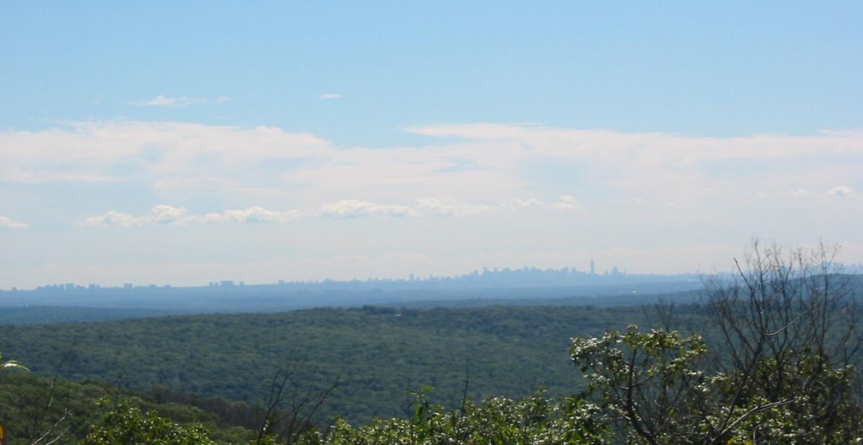
This loop hike traverses several historic Scout trails, climbs to panoramic viewpoints, and follows a picturesque stream.
41.047479, -74.251313
Bergen Co., NJ
8 mi
5 hrs

Avenza App Map: Northern New Jersey Highlands 150
Hike Checklist:
Whether you are going for a day hike or backpacking overnight, it is good practice to carry what we call The Hiking Essentials. These essentials will help you enjoy your outing more and will provide basic safety gear if needed. There may also be more essentials, depending on the season and your needs.
The Essentials
Hiking Shoes or Boots
Water - Two quarts per person is recommended in every season. Keep in mind that fluid loss is heightened in winter as well as summer. Don't put yourself in the position of having to end your hike early because you have run out of water.
Map - Know where you are and where you are going. Many of our hiking areas feature interconnecting network of trails. Use a waterproof/tear-resistant Tyvek Trail Conference map if available or enclose your map in a Ziplock plastic bag. If you have a mobile device, download Avenza’s free PDF Maps app and grab some GPS-enhanced Trail Conference maps (a backup Tyvek or paper version of the map is good to have just in case your batteries die or you don't have service). Check out some map-reading basics here.
Food - Snacks/lunch will keep you going as you burn energy walking or climbing. Nuts, seeds, and chocolate are favorites on the trail.
Sunscreen and insect repellent
Rain Gear and Extra Clothing - Rain happens. So does cold. Be prepared for changing weather. Avoid cotton--it traps water against your skin and is slow to dry. If you are wearing wet cotton and must return to your starting point, you risk getting chills that may lead to a dangerous hypothermia. Choose synthetic shirts, sweaters and/or vests and dress in layers for easy on and off.
Compass - A simple compass is all you need to orient you and your map to magnetic north.
Light - A flashlight or small, lightweight headlamp will be welcome gear if you find yourself still on the trail when darkness falls. Check the batteries before you start out and have extras in your pack.
First Aid Kit - Keep it simple, compact, and weatherproof. Know how to use the basic components.
Firestarter and Matches - In an emergency, you may need to keep yourself or someone else warm until help arrives. A firestarter (this could be as simple as leftover birthday candles that are kept inside a waterproof container) and matches (again, make sure to keep them in a waterproof container) could save a life.
Knife or Multi-tool - You may need to cut a piece of moleskin to put over a blister, repair a piece of broken equipment, or solve some other unexpected problem.
Emergency Numbers - Know the emergency numbers for the area you're going to and realize that in many locations--especially mountainous ones, your phone will not get reception.
Common Sense - Pay attention to your environment, your energy, and the condition of your companions. Has the weather turned rainy? Is daylight fading? Did you drink all your water? Did your companion fail to bring rain gear? Are you getting tired? Keep in mind that until you turn around you are (typically) only half-way to completing your hike--you must still get back to where you started from! (Exceptions are loop hikes.)
Check the weather forecast before you head out. Know the rules and regulations of the area.
The Leave No Trace Seven Principles
Plan Ahead and Prepare
- Know the regulations and special concerns for the area you'll visit.
- Prepare for extreme weather, hazards, and emergencies.
- Schedule your trip to avoid times of high use.
- Visit in small groups when possible. Consider splitting larger groups into smaller groups.
- Repackage food to minimize waste.
- Use a map and compass to eliminate the use of marking paint, rock cairns or flagging.
Travel and Camp on Durable Surfaces
- Durable surfaces include established trails and campsites, rock, gravel, dry grasses or snow.
- Protect riparian areas by camping at least 200 feet from lakes and streams.
- Good campsites are found, not made. Altering a site is not necessary.
- In popular areas:
- Concentrate use on existing trails and campsites.
- Walk single file in the middle of the trail, even when wet or muddy.
- Keep campsites small. Focus activity in areas where vegetation is absent.
- In pristine areas:
- Disperse use to prevent the creation of campsites and trails.
- Avoid places where impacts are just beginning.
- Pack it in, pack it out. Inspect your campsite and rest areas for trash or spilled foods. Pack out all trash, leftover food and litter.
- Deposit solid human waste in catholes dug 6 to 8 inches deep, at least 200 feet from water, camp and trails. Cover and disguise the cathole when finished.
- Pack out toilet paper and hygiene products.
- To wash yourself or your dishes, carry water 200 feet away from streams or lakes and use small amounts of biodegradable soap. Scatter strained dishwater.
- Preserve the past: examine, but do not touch cultural or historic structures and artifacts.
- Leave rocks, plants and other natural objects as you find them.
- Avoid introducing or transporting non-native species.
- Do not build structures, furniture, or dig trenches.
- Campfires can cause lasting impacts to the backcountry. Use a lightweight stove for cooking and enjoy a candle lantern for light.
- Where fires are permitted, use established fire rings, fire pans, or mound fires.
- Keep fires small. Only use sticks from the ground that can be broken by hand.
- Burn all wood and coals to ash, put out campfires completely, then scatter cool ashes.
- Observe wildlife from a distance. Do not follow or approach them.
- Never feed animals. Feeding wildlife damages their health, alters natural behaviors, and exposes them to predators and other dangers.
- Protect wildlife and your food by storing rations and trash securely.
- Control pets at all times, or leave them at home.
- Avoid wildlife during sensitive times: mating, nesting, raising young, or winter.
Be Considerate of Other Visitors
- Respect other visitors and protect the quality of their experience.
- Be courteous. Yield to other users on the trail.
- Step to the downhill side of the trail when encountering pack stock.
- Take breaks and camp away from trails and other visitors.
- Let nature's sounds prevail. Avoid loud voices and noises.
The Trail Conference is a 2015 Leave No Trace partner.
(c) Leave No Trace Center for Outdoor Ethics: www.LNT.org.
Directions to Trailhead :
Take I-287 to Exit 57 (Skyline Drive) and proceed north on Skyline Drive for a little over a mile to the upper parking area for Ramapo Mountain State Forest on the left side of the road (at milepost 1.4, opposite the entrance to Camp Tamarack).
TRAIN TRANSPORT :
Not availableBUS TRANSPORT :
Not availableShare Your Experience

SUPPORT
 Support the trails with a donation!
Trail Conference volunteers maintain trails in this hike.
Trip Reports
rate experience June 10, 2018
Old Guard Trail is overgrown again
These directions are great, but as of June 4, 2018 the Old Guard Trail is very overgrown and some of the blaze markers are hard to see. Be very careful in following the directions and make sure you are constantly seeing the blazes as you go.
December 31, 2014
Old Guard Trail is now in excellent condition
<p>I did this hike yesterday (December 30, 2014) and found the Old Guard Trail to be in excellent condition. It seems that significant maintenance has been done on this trail since last June, and all of the blowdowns have been removed. The Old Guard Trail is not extensively used, but it is a very interesting loop around a relatively remote area of Camp Glen Gray.</p>
June 07, 2014
Old Guard Trail Maintenance Needed
<p>Did this hike yesterday (June 6, 2014). Great hike, good directions and well blazed. But The Old Guard Trail really needs some attention. Very overgrown, lots of blowdowns that obscure where the trail even goes. If not for the (thankfully) great blazing, we'd have been wandering all over looking for the trail. Either it's just not used that much or it's been relegated to lower priority on trail maintenance lists. Only established in 2008 by the NJ/NJ TC, it's a great trail otherwise, but needs a lot of TLC or just more traffic!</p>