
Summer 2022 Map and Book Updates
August 15, 2022
New York-New Jersey Trail Conference
Title
Summer 2022 Map and Book Updates
Body
Our Publications Committee has continued to be quite busy recently, so here is an overview of recently published titles and upcoming updates as of mid-September.
Recent Maps and Books:
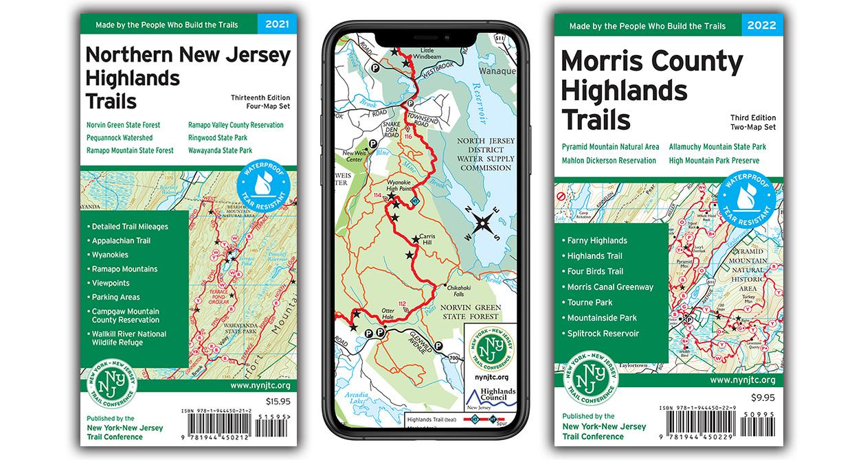
- Northern New Jersey Highlands Trails map set
This basically brand-new map replaced our popular North Jersey Trails map at the end of 2021, and if you haven’t gotten your copy yet of this significantly improved map set, be sure to check it out! It features more than 360 miles of trails, more than 40 parks and preserves, an increased scale and new trail mileage numbers, upwards of 75 miles of trail updates for trail additions and changes completed over the past few years by Trail Conference volunteers, and so much more. In addition to the print Tyvek version, it is available on Avenza Maps as a combined app map that combines the four primary section maps. Click here to learn more and grab your print or digital copy.
- Reflections book
Also released near the end of 2021, we published our Reflections book in celebration of our Centennial. Printed in full color with photos documenting the full history of the Trail Conference, this is a must-have book to learn more about the people who have led our past century of passion for the trails. Click here to learn more and grab your print copy.
- Highlands Trail in New Jersey maps
Published as a free app map on Avenza Maps at the end of 2021, this map highlights more than 130 miles of the Highlands Trail through New Jersey and into southern New York. This is the first detailed map of this section of the Highlands Trail as it travels through nearly 30 parks in New Jersey, including more than 150 parking locations to access the Highlands Trail and trails in nearby parks. Along with a recently-completed signage project, these new maps will help bring more attention to this awesome long distance trail! Click here to learn more and grab these free maps.
- Avenza Maps
This past spring, Avenza released a major update to their app with a refreshed design and logo, enhanced map store, and other helpful improvements throughout the app. Be sure to grab the latest version if you use the app. If you’re unfamiliar with this popular app, or would like to learn more about the latest updates and learn some tips about using the app, click here to view our new Overview Presentation. We currently offer more than 85 great trail maps, including both free and for-sale maps, so check it out today on your Apple or Android device!


Upcoming Maps:
- Map delays due to Tyvek supply issues
Did you know the Trail Conference has been printing our maps on waterproof and tear-resistant Tyvek for nearly 50 years? Currently, Tyvek for graphics/printing purposes is in extremely limited supply, and we have been working throughout the past year to find enough Tyvek for our map printings. We have unfortunately been unable to obtain enough Tyvek for significant 2022 revisions to our Catskill Trails maps and Morris County Highlands Trails maps, so the printing of both maps is delayed without a clear timeframe of expected availability, although we are hopeful that printed maps may be available before the end of the year..
Tyvek is a material produced by DuPont that has a wide variety of applications in various industries, including mailing envelopes, insulation wrap for homes, and medical gowns and coveralls. For the past 2 years, DuPont has shifted their production toward their healthcare and PPE products to meet the need of the global pandemic, which has left the other products like we use in limited and dwindling supply, and global supply chain issues have only heightened the uncertainty of when supplies may increase again. We continue to be in contact with multiple suppliers to try to secure enough Tyvek to get these maps printed, and we understand this situation is not helpful for customers looking for a print map.
In the absence of print maps, digital versions of our maps are being published on the Avenza Maps app. The Morris County Highlands Trails app maps are currently available, and the new edition of the Catskill Trails app map is in progress and expected to be available in early fall.
- Morris County Highlands Trails map set
Formerly titled Jersey Highlands Trails: Central North Region, this 3rd edition map features more than 230 miles of trails in the New Jersey Highlands of northern Morris County and nearby counties. The 2022 update includes significant trail changes, including new trails and blazing changes in several parks including Pyramid Mountain, Mountainside Park, Tourne County Park, Wildcat Ridge Wildlife Management Area, Jonathan’s Woods, Farny State Park, Mahlon Dickerson Reservation, High Mountain Park Preserve, and Mount Hope Historical Park. The maps are currently only available digitally through the Avenza Maps app as the printing is delayed due to Tyvek shortages. Click here to learn more, including links to download the maps on Avenza Maps.
- Catskill Trails map set
Work on a revised 13th edition of this popular map is nearing completion, and we hope to have digital app map versions available in early fall. Last updated in 2018, this updated map includes several significant changes, including new trails like the Red Hill Fire Tower Trail and trails within Bluestone Wild Forest, several trail lines updated with newer GPS data, the addition of several viewpoint stars and removal of some stars at overgrown locations, adjustments near Doubletop and Graham mountains to indicate no public access, and the addition of several newly-protected lands. Click here to see updates about availability; please note a limited number of copies of the 2018 12th edition are still available for purchase.
- East Hudson Trails map set
We are working fast to complete a revised 13th edition of this map, which was also last updated in 2018, and are aiming to have digital maps on Avenza Maps this fall. There have been many changes over the past few years, including new trails in Hudson Highlands State Park Preserve and Fahnestock State Park and in-progress trail relocations and updates throughout these parks. Other significant updates to the maps include trail lines that have been completely redrawn with the latest data, new parking and trail access locations, the addition of several new viewpoint stars, the inclusion of a portion of the trails at Granite Mountain Preserve, and the addition of several newly-protected lands. Click here to see updates about availability; please note copies of the 2018 12th edition are still available for purchase.


Our Publications Committee volunteers are also continuing work on other upcoming projects, including a new book focused on trails in Morris County entitled Afoot in Morris, updates to the Hiking Long Island book, and revisions to other maps including Hudson Palisades and Shawangunk. We can always use help to reach our goals of providing authoritative trail content to users throughout the region, so if you might have the time and interest to assist with the efforts of this committee, please visit www.nynjtc.org/volunteer and click on Volunteer Openings to discover openings with our Publications work.