Digital Trail Maps on Mobile Devices

Get the Latest Digital Trail Maps on Your Phone or other Mobile Device!


Avenza Maps 2022

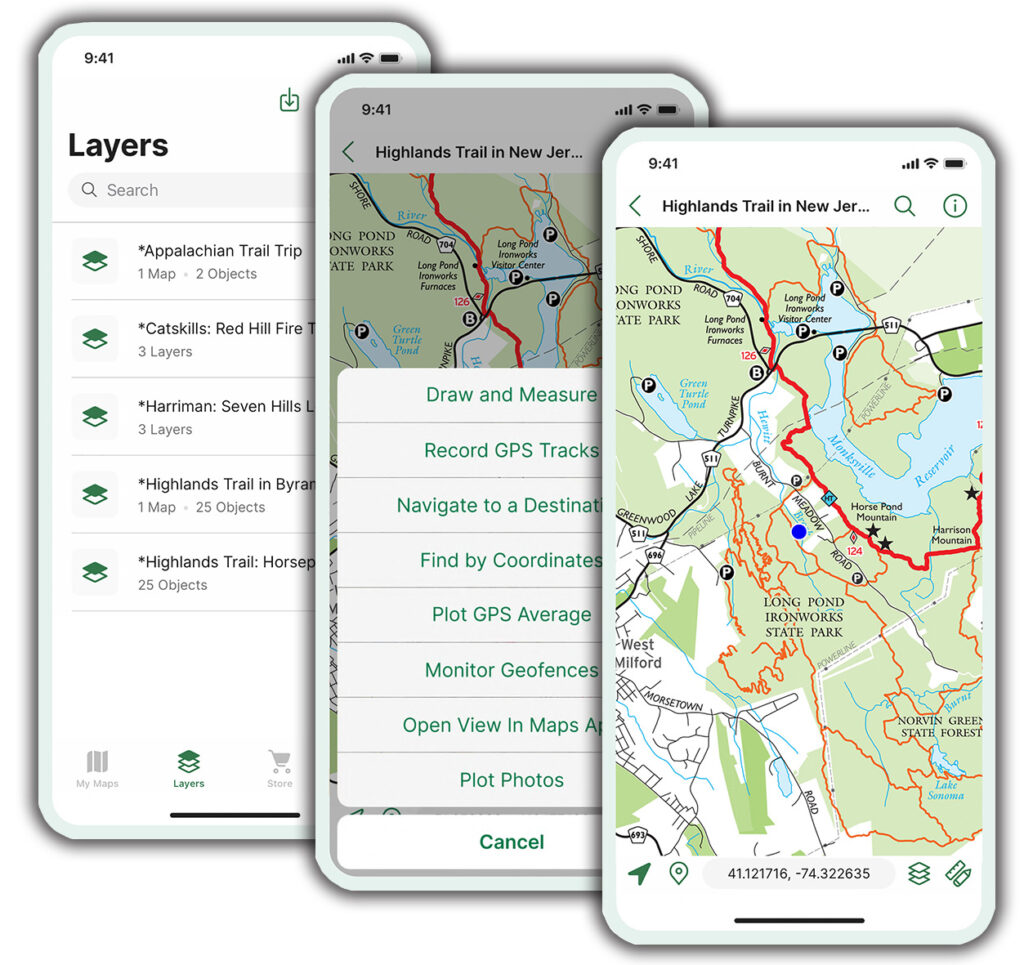
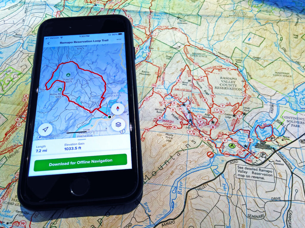
Be prepared with digital trail maps from the New York-New Jersey Trail Conference.  Our popular trail maps are available on Apple iOS and Android devices using the Avenza Maps app.  Enhance your outdoor experience by using our app maps to pinpoint your location with GPS (even in areas of no cell coverage), track your route, and navigate the trails in an exciting new way.  More than a 300,000 of our digital trail maps have been downloaded by trail users, so view Trail Conference maps on AvenzaMaps.com today to get started!
 

Get Started in a few easy steps:

  1. Download the free Avenza Maps app from Apple's App Store or from Android's Google Play.
  2. Open the app, go to the Map Store, and search by location or keyword (like "harriman state park"), or use the map to find Trail Conference maps near you.
  3. Tap on a map to preview it and read a description.
  4. Tap to either install a free map or purchase a for sale map.
  5. Your map is stored on your device within the app's Map Library, and you're ready for exploring!


For additional help with the app and learn about all the features of the app, please check out our latest User Guides!

Avenza Maps Guide Spring 2022


Ways to use the Avenza Maps app

Some of the things you can do with the Avenza Maps app are:Avenza Maps 2022

  • User your device's GPS to see your real-time position on the map without an internet connection
  • Track your movements and check speed and distance statistics
  • Plan and measure your trail route
  • Record locations of features and add photos
  • Orient yourself with a built-in compass
  • Import and export map data to share with others (internet connection needed)
  • Carry all your maps on one small device
  • Record the location of a trail problem, take a photo of the problem, and send the information to the Trail Conference


Frequently Asked Questions

  • Is the Avenza Maps app free?
    Yes.  Within the free app, there are both free and for-sale digital trail maps available for download.
  • Do I need an internet connection to use this app?
    Initially, you will need an internet connection (WiFi or cellular service) to download the app and download digital trail maps.  Once a map is downloaded, it is stored on the device and is viewable and functions with most tools without an internet connection.
  • Does this digital app map replace the need for a printed map?
    No.  These digital app maps are not a replacement for printed maps that every trail user should have on hand.  Batteries can die, software can have issues, and weather can become problematic, so we certainly suggest you carry printed maps just in case.
  • Are member discounts available, or are discounts for purchasing both print and digital maps available?
    No.  Discounts are currently not available on digital app maps.
  • Can I view the digital app map on my computer like I might view a PDF file?
    No, each digital app map is only viewable within the app.
  • Can I print out a copy of this digital app map?
    No, the app does not support printing.
  • Should I be worried about my device's battery life?
    Battery life depends on many factors, but short trips should minimally affect your device's battery.  For longer trips, you should monitor your battery life more closely.  To improve battery life, try adjusting brightness, closing other background apps, and turning off extraneous things like Wi-Fi, Bluetooth, notifications and e-mail syncing.
  • Who should I contact if I have issues with the App?
    Visit the Avenza Support Center to learn more about the app, troubleshoot, or ask questions about issues.
     

List of Trail Conference digital trail maps available in the Avenza Maps app

More than 85 Trail Conference maps are currently available, including free maps and maps for purchase.  Please note that map bundles group individual maps similar to print map sets. To view our complete catalog of digital app maps, visit the Trail Conference map page on AvenzaMaps.com.

Combined/Bundle Maps:

For Sale Maps:

Map Title

Map Number

Parks

Sterling Forest - 2020
100
 Sterling Forest State Park, Appalachian Trail, Tranquility Ridge County Park, Highlands Trail
East Hudson (South) - 2023
101
 Hudson Highlands State Park Preserve, Hudson Highlands Gateway Park, Manitoga, Manitou Point Preserve, Appalachian Trail
East Hudson (North) - 2023
102
 Hudson Highlands State Park Preserve, Fishkill Ridge Conservation Area, Mount Beacon Park
East Hudson (Fahnestock) - 2023
103
 Fahnestock State Park, Appalachian Trail
Shawangunk (South) - 2019
104
 Minnewaska State Park Preserve, Sam's Point Preserve, Long Path
Shawangunk (North) - 2019
105
 Mohonk Preserve, Mohonk Mountain House, Minnewaska State Park Preserve
Shawangunk (Mohonk Mountain House) - 2019
106A
 Mohonk Mountain House, Mohonk Preserve
Shawangunk (Shawangunk Ridge Wurtsboro) - 2019
106B
Shawangunk Ridge State Forest, Roosa Gap State Forest, Wurtsboro Ridge State Forest
South Taconic - 2015
107
Taconic State Park, Mount Washington State Forest (Mass.), 34 Miles of the Appalachian Trail in Conn. & Mass.
Hudson Palisades (#1) - 2018
108
Palisades Interstate Park, Flat Rock Brook Nature Center, Tenafly Nature Center, Lost Brook Preserve, Long Path
Hudson Palisades (#2) - 2018
109
Palisades Interstate Park, Tallman Mountain State Park, Blauvelt State Park, Clausland Mountain County Park, Buttermilk Falls County Park, Rockleigh Woods Sanctuary, Lamont Reserve, Long Path
Hudson Palisades (#3) - 2018
110
Hook Mountain State Park, Nyack Beach State Park, Long Path
Hudson Palisades (#4) - 2018
111
Rockland Lake State Park, Hook Mountain State Park, Haverstraw Beach State Park, Long Path
Hudson Palisades (#5) - 2018
112
High Tor State Park, South Mountain County Park, Gurnee County Park, Long Path
West Hudson (East) - 2019
113
Storm King State Park, Black Rock Forest, Highlands Trail
West Hudson (West) - 2019
114
Schunemunk State Park, Long Path, Highlands Trail
North Jersey (see new "Northern New Jersey Highlands" maps 150-154)
115, 116
 
Harriman-Bear Mountain (South) - 2023
118
Southern Harriman State Park, Long Path
Harriman-Bear Mountain (North) - 2023
119
Northern Harriman State Park, Bear Mountain State Park, Appalachian Trail, Long Path
Delaware Water Gap & Kittatinny (South 1) - 2021
120
Southern Delaware Water Gap National Recreation Area, Worthington State Forest, Appalachian Trail
Delaware Water Gap & Kittatinny (South 2) - 2021
121
Southern Delaware Water Gap National Recreation Area, Appalachian Trail
Delaware Water Gap & Kittatinny (North 1) - 2021
122
Northern Delaware Water Gap National Recreation Area, Stokes State Forest, Appalachian Trail
Delaware Water Gap & Kittatinny (North 2) - 2021
123
Northern Delaware Water Gap National Recreation Area, High Point State Park, Huckleberry Ridge State Forest, Port Jervis Watershed Park, Appalachian Trail
Morris County Highlands (East) - 2023
125
Pyramid Mountain, Farny State Park, Wildcat Ridge Wildlife Management Area, Pequannock Watershed, Highlands Trail
Morris County Highlands (West) - 2023
126
Mahlon Dickerson Reservation, Mount Hope Historical Park, Rockaway River Wildlife Management Area, Highlands Trail
Morris County Highlands (Allamuchy/Stephens) - 2023
127
Allamuchy Mountain State Park, Stephens State Park, Highlands Trail, Morris Canal Greenway
Morris County Highlands (High Mountain) - 2023
128
High Mountain Park Preserve
Westchester (Rockefeller) - 2020
130
Rockefeller State Park Preserve, Rockwood Hall Area, Peabody Preserve, Pocantico Park, Tarrytown Lakes Park, Westchester RiverWalk, Old Croton Aqueduct, North County Trail
Westchester (Ward Pound Ridge) - 2020
131
Ward Pound Ridge Reservation, Armstrong Preserve, Lewisboro Town Park, Old Field Preserve, Richards Preserve
Westchester (Teatown) - 2020
132
Teatown
Westchester (Greater Teatown) - 2020
133
Teatown, Teatown-Kitchawan Trail, Briarcliff-Peekskill Trail, Croton Gorge Park, Old Croton Aqueduct, North County Trail
Catskill (North Lake) - 2023
140
North/South Lake Campground, Escarpment Trail, Kaaterskill Falls, Long Path, North Mountain
Catskill (Northeastern) - 2023
141
Blackhead Range, Hunter Mountain, Devil's Path, Escarpment Trail, Tremper Mountain, Overlook Mountain, Kaaterskill Falls, North/South Lake Area, Long Path
Catskill (Central) - 2023
142
Panther Mountain, Balsam Mountain, Belleayre Mountain, Dry Brook Ridge, Balsam Lake Mountain, Halcott Mountain, Bearpen Mountain, Long Path
Catskill (Southern) - 2023
143
Slide Mountain, Burroughs Range, Peekamoose Mountain, Beaver Kill Range, Vernooy Falls, Long Path, Finger Lakes Trail
Catskill (Western) - 2023
144
Delaware Wild Forest, Trout Pond, Little Pond, Mongaup Pond, Frick Pond, Finger Lakes Trail
Catskill (Long Path North) - 2023
147
Huntersfield Mountain, Ashland Pinnacle, Richmond Mountain, Mount Pisgah, Mount Hayden, Long Path
Catskill Hikes - Kaaterskill Falls & North/South Lake, NY
---
North/South Lake Campground, Kaaterskill Falls, Kaaterskill Rail Trail
Northern New Jersey Highlands (Ramapos) - 2021
150
Campgaw Mountain County Reservation, Ramapo Mountain State Forest, Ramapo Valley County Reservation, Ringwood State Park
Northern New Jersey Highlands (Wyanokies) - 2021
151
Long Pond Ironworks State Park, Norvin Green State Forest, Ringwood State Park, Tranquility Ridge County Park, Highlands Trail
Northern New Jersey Highlands (Wawayanda & Bearfort Ridge) - 2021
152
Abram S. Hewitt State Forest, Appalachian Trail Corridor, Pequannock Watershed, Wawayanda State Park
Northern New Jersey Highlands (Pequannock Watershed) - 2021
153
Pequannock Watershed north of Route 23, portion of Wawayanda State Park, Highlands Trail
Northern New Jersey Highlands (A.T. Corridor) - 2021
154
Appalachian National Scenic Trail, Wallkill River National Wildlife Refuge, Wawayanda State Park
Lenape Trail Detailed Map - 2019
 
The Lenape Trail through Essex County, NJ

Free Maps:

We are continually adding maps, so be sure to check back often for new additions
 

Remember: Batteries die. Our printed maps are light-weight backups AND they are printed on waterproof, tear-resistant Tyvek, so be sure to visit our online store for all your print map needs!

Trail Conference Printed Maps

Comment: Please be relevant, civil, non-commercial.

Suzy's picture

I'm slowly adding these to my Iphone.  I bring the paper maps with me as well.  Iphones can be a distraction on the trails, but what the hay. Love all three sets of maps I have for all the trails: the electronic version, the maps I bring with me, and the maps I hang in my house with the highlighted trails I've completed. These are great gifts for your city-living friends.
jay's picture

The idea is really a great one. I purchased 8 maps to use on my galaxy s4 for Android device. The Android software is of limited use at this point because you cannot record your track or save your points  to plan a trip. I think the release was a little premature and should have waited for basic features that would make this a good tool. You Can however see where you are at all times, measure distances in the field, as well as more easily find the trailhead.  
Jeremy Apgar's picture

The Android version of this app just came out at the end of September, and it includes a number of great features that work to enhance our trail maps.  The ability to record/import/export tracks is not yet available; this feature just became available on the 2.0 iOS version of the app, so this feature will likely come to Android as well.  You can use the app to record/import/export placemarks, so this is a useful way to plan a trip or keep track of particular points. We realize that this app may not satisfy the desires of everyone, and we will continue to ask the app developer to work on bringing track recording to the Android app.  But even without that, the many tools and features that are currently available make this a great solution for many out on the trail.  We have heard firsthand from a number of users that one feature in particular, being able to pinpoint your location directly on the trail map, has helped them either keep from getting lost or get back onto their intended route after going slightly astray. Thank you for your comments, and I hope you are able to use the maps on your adventures. ~Jeremy, TC cartographer
jay's picture

Hi  jeremy your cartography and paper maps are stunning and I enjoy them immensly. yes you can import and export place marks but you cannot navigate to them like you do with a gps track point. a tracking function would allow a user to follow their way back from a geocache or side trip etc. it would essentially put a backup gps in the hands of every hiker and result in alot less people being lost.  I would pay a premium for the track feature.  perhaps ultimately one day the app will be able to follow the curvature  of the trail lines to give you accurate trail distances or have nav abilities. track however is the most important thing missing.        
jonboy's picture

I am using this app with a Galaxy S3.  What I like most about this new app is the clarity of the screen image.  I have been using Backcountry Navigator Pro with GPX tracks up loaded, but these tracks were overlayed onto a USGS map and are difficult to read, except at a very large magnification, as the map is too busy.  I also like the fact that the image on the screen is an exact duplicate of the map I am carrying, so that I can quickly transition to a paper map.  I also carry a high end Garmin, which is much more accurate for track recording and Geocaching, but this is a function of the limitations of the phone GPS, not the app. On my most recent hike I used the PDF app exclusively, never even pulling the paper map out, even when showing another hiker where we were while he looked over my shoulder.  I also like the fact that when I buy these maps, I am supporting the Trail Conference.  I highly recommend this app.
Jeremy Apgar's picture

Thank you very much for the great feedback and recommendation!  We're glad to hear people using the map app on their explorations.  The exact replica of the paper map, which can also be enlarged greatly on the screen if necessary, is one of the most helpful features users have mentioned.  I have found myself showing other hikers the map on the app rather than the paper map as well!  And we of course appreciate the support with your purchase, as these sales help the organization perform its trail work.~JeremyTC cartographer
banjolady's picture

i also love this app, using it on galaxy s3 but hope it gets the routing, tracking and measuring capability on android that it has on IOS. meanwhile i had bought the NJ maps 115 and 116 and they just upgraded to 2014. i tried to update but they charged me again for the same map! is this going to be true for all the maps as they upgrade we need to repurchase them? i bought them within the last 6 months...thanks susan
Jeremy Apgar's picture

Hi Susan! I'm glad you're getting great use of these app maps on your S3.  We are also hoping the tracking capabilities are made available on Android soon, as it is a great feature for use on the trails! For our paid maps in the app, whenever a new edition is made available, it is treated as a new map item to be purchased.  This is the same as our printed Tyvek maps, as we charge for new editions.  With the paid map apps, it should be noted that you don't lose access to an old edition when a new edition becomes available.  For example, if you paid for the 2012 North Jersey maps and did not want to pay for the new 2014 versions, you can continue to use the 2012 maps (and do things such as download the maps on multiple devices). I think I will add this question and response to our Frequently Asked Questions section above to provide clarification for others.  And I thank you for your support of the Trail Conference's work through your map purchases. ~Jeremy, TC Cartographer
smithg2010's picture

  (probably not the right place for this post, please move to appropriate section.)   I notice that in the past couple of years, National Geographic has come out with trail maps for both the Catskills and Harriman/Sterling Forest. I was wondering what is the driving force behind this?  I would think National Geographic must have bigger fish to fry than Bear Mountain ...? It also appears that the ADK club now packages the Nat Geo maps with their books (although they still offer their own maps for separate sale).  Is the Trail Conference considering a similar partnership with Nat Geo?
Daniel Chazin's picture

National Geographic has, indeed, in recent years, come out with maps for the Catskills, Harriman-Bear Mountain, Sterlng Forest, and Delaware Water Gap (Kittatinnies), all of which cover areas that are already covered by Trail Conference maps.  I think that the motivating force behind these maps is that they are popular hiking areas, and National Geographic wants to have maps that cover all important hiking areas in the United States.  These maps do, of course, compete with our Trail Conference maps, but we believe that our maps are vastly superior to the National Geographic maps for a number of reasons, including the size of the maps, their readability and their accuracy.  Our customers seem to agree, as sales of our maps have not been impacted in any significant way by the appearance of the National Geographic maps. By the way, the National Geographic maps generally cover a broader area than the Trail Conference maps, as they include much adjacent private land that does not have any trails.  They make excellent road maps, and I highly recommend them for this purpose.  But if you're interested in a trail map, our Trail Conference maps are far superior. Since we produce our own trail maps, which we believe to be superior to those produced by National Geographic, we see no reason to partner with National Geographic to package their maps with our books.
mtneer183's picture

What's the cost of an electronic trail map?  Are there any proposed opportunities for bundling electronic maps, thereby offering a discount (e.g. buy four maps and get the fifth one free)?
Jeremy Apgar's picture

The trail maps we currently offer through the free app range in price from Free to $5.99 per map.  Our free map offerings generally include either small parks or areas not covered by our regular Tyvek maps.  The for-sale map offerings are basically digital versions of our published Tyvek maps, and they go from $0.99 up to $5.99 based primarily on their coverage area and the amount of trails contained on the map (for instance, maps with more than 100 miles of trails are either $4.99 or $5.99).   We have not yet looked into creating bundles as you suggest, but that may certainly be a great incentive to offer along with other discounts such as receiving a discount on a digital version if you purchase the Tyvek version, etc.  I appreciate your inquiry and suggestion.   ~Jeremy, TC Cartographer
jay's picture

I am really glad the tracking feature was added in the latest android version. I can't wait to try it. Now this is complete....
Jeremy Apgar's picture

We are very excited as well!  The ability to capture/upload/download tracks is great to see.  In addition, the newest Android version also allows for the geotagging of photos so that photo locations can be captured with placemarks/waypoints. Enjoy the maps out on the trails!   ~Jeremy, TC cartographer
willdrad's picture

I wish you had a map of Highlands Trail. Also the Appalachian Trail. From state line to state line. Thanks
Jeremy Apgar's picture

Currently, important maps showing all of the Appalachian Trail, Long Path, and Highlands Trail are not in our digital map offereings, except for where portions of these trails occur on our available maps.  While the Appalachian Trail is covered by print maps, both the Long Path and Highlands Trail are not yet covered in their entirety by print maps.  We have plans in place to produce such maps for both the Long Path and Highlands Trail, both in some sort of print/downloadable form as well as digitally through the PDF Maps app.  These projects are large undertakings that we hope to be able to provide to individuals like yourself in the near future, so stay tuned!~Jeremy, TC Cartographer
seopious's picture

I am really very very glad the tracking feature was added in the latest . I will surly give it a try.
pintoj's picture

When maps are updated will we receive a discount on purchasing updates to maps we have already purchased in the app?
Jeremy Apgar's picture

Thanks for your inquiry about pricing for updated maps.Our digital maps through the PDF Maps app are currently treated the same as our printed Tyvek maps when it comes to new editions.  When a revised digital map is made available, it is a new map item to be purchased; the old edition is not replaced, and you don't lose access to an old edition when a revised edition becomes available.While our digital maps have been extremely popular, we do need to look at opportunities to promote them further and to new users, and part of that could include things such as discounts for revised editions, discounts for purchasing both print and digital maps, subscriptions for the latest print and digital maps, etc.  Each of these has many factors to consider, including working with the app developer to implement certain things.  These digital maps are still a relatively new product space for us, so we'll continue to develop the products as we hear more from users like yourself.  Anyone is welcome to send their thoughts to me directly, or post a comment/question on this page.Thank you for your support of the Trail Conference!~Jeremy, TC Cartographer
jay's picture

(edited) I had purchased  11 of your Android maps (2013 version). I got a new phone, and had problems moving the maps. Jeremy contacted me and helped me out, and all is well now.   Thanks for the great customer service, and the beautiful maps.   Jay
Jeremy Apgar's picture

I'm glad we were able to resolve your issue!  I have added information above to help others who may experience a similar issue (an optional Step 6 in the step-by-step instructions), so I thank you for bringing this to our attention.Enjoy the maps on your new phone!~Jeremy, TC Cartographer
Ray Lin's picture

I have iPad and iPhone.  Do I need to buy 2 copies of the same pdf map?
asimo042's picture

I have been tracking the conversation. It seems that paper and app maps are readily available. What are the news on the GPS front? Thank you.
Jeremy Apgar's picture

Currently, we do not offer any maps in digital format for use on handheld GPS units like those from Garmin and other manufacturers.  They are only available in digital format through the Avenza Maps app as described elsewhere on this page.

I hope that helps answer your question!

~Jeremy, Trail Conference cartographer

jwrushman's picture

I recently started using Avenza Maps for hikes in Harriman. I like being able to see where I am on the map when hiking. However, I feel like I don't know how to use the applications features and haven't found much help on Google and YouTube. On the NY-NY-TC website it mentions "Track your movements and check speed and distance statistics." "Plan and measure your trail route." How do I do this? I know how to record a GPS track and that give me time and distance stats, but how do you get statistics during the walk. And how does one "plan and measure" a trail route. Fortunately, the Harriman maps have excellent info on point-to-point distance, but most other maps don't.