71 miles of the Shawangunk Ridge Trail are maintained by volunteers and member groups.
Free, downloadable maps, of the southern gunks. See ad at right and links below.
A trail description of the southern half of the The Shawangunk Ridge Trail can be found in The Long Path Guide.
The northern half of the The Shawangunk Ridge Trail is shown on the Shawangunks map set.

 |
The Shawangunk Ridge Trail
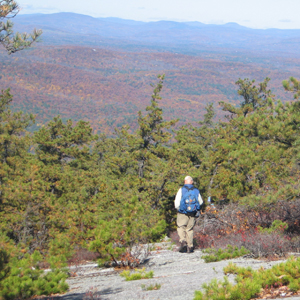
The Shawangunk Ridge Trail (SRT - blue blazes) starts at the Appalachian Trail in High Point State Park in New Jersey and heads north along the southern Shawangunks, then northeast through Sam's Point Preserve, Minnewaska State Park and the Mohonk Preserve in New York. It generally follows the spectacular Shawangunk Ridge, occasionally using local roads and abandoned rail beds.
In about 12 miles the Shawangunk Ridge Trail joins the Long Path in the town of Greenville, and it is co-aligned with the LP for the next 34 miles. After crossing Route 211 and going over Gobblers Knob, the trail descends to the Basha Kill Wildlife Management Area. The Basha Kill is an extensive wetland offering many opportunities for bird watching and other wildlife viewing. North of the Basha Kill, the SRT passes through the Village of Wurtsboro and then ascends the Wurtsboro Ridge.
The next 10 miles along the ridgetop are among the most spectacular in New York State with the open views of the Catskills looming in the distance, and views all the way back to High Point. Once the trail crosses Route 52, it ascends to Sam's Point Preserve and continues to Verkeerder Kill Falls, Minnewaska State Park and the Mohonk Preserve on its way north and east. The Long Path leaves the SRT in Minnewaska, and the SRT is then co-aligned with existing trails through Minnewaska and Mohonk. The trail is currently blazed to Mountain Rest Road near the main entrance to Mohonk Mountain House, from where one can follow local roads to the Wallkill Valley Rail Trail and the Rosendale Trestle.
The SRT was initiated by the Trail Conference in 1989 and continues to be a work in progress. The Trail Conference and its partners work to protect a ridge-length trail corridor and connect the trail to other trails along the way.
The Trail Conference is pleased to offer hikers free maps of the SRT via download to your computer. These maps have been fully revised to reflect many minor and some major changes. Four separate maps cover the current existing trail; each prints on an 8.5 x11-inch page. These maps complement the detailed description of the southern SRT found in The Long Path Guide.
** Map 1 (southern end) - High Point to Graham Fire Tower
** Map 2 - Graham Fire Tower to Wurtsboro
** Map 3 - Wurtsboro to Minnewaska
** Map 4 (northern end) - Minnewaska to Mohonk
The SRT also serves as an alternative route on the Long Path for the hiker who wishes to avoid the lowlands of Orange County. Upon reaching the intersection with the Appalachian Trail in Harriman Park, the hiker follows the AT south to High Point State Park in New Jersey, then goes north on the SRT to meet the Long Path in Greenville.
Comment: Please be relevant, civil, non-commercial.
Northern SRT and LP
Northern SRT and LP
Gobbler's Knob
Error on Trail Map
I just noticed that the map of the southern part of the Shawangunk Ridge Trail has a spelling error. The park outside Port Jervis is Elks - Brox Park not Elks - Bronx Park.
Tad Thayer Greenville Residents for Informed Planning (GRIP)
Error Noted!
Tad,
Thanks for bringing this error to our attention. Soon after we produced this map, I created a map detailing trails in and around Port Jervis and noticed this spelling error, so it has been noted for when we make revisions to these maps.
~Jeremy, Trail Conference cartographer
I've alerted our map maker