Hike: Catskill Escarpment Loop (South)
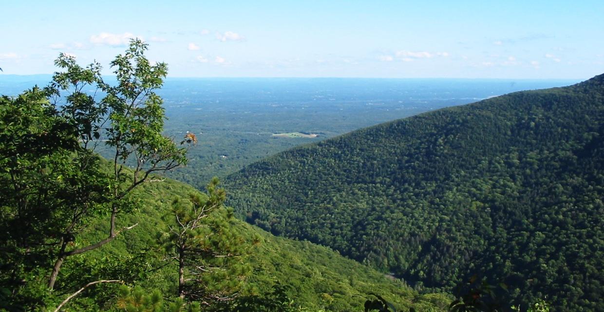
View East from Escarpment Trail just beyond Inspiration Rock – Photo by Daniel Chazin
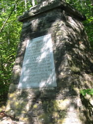
This 5.5-mile loop along the Escarpment Trail offers a stunning introduction to the dramatic cliffs and historic viewpoints of the northern Catskills. Beginning near North/South Lake, the route quickly crosses old railroad beds and the lake’s outlet stream before climbing steadily into a forested ridge. Early in the hike, a stone monument quietly honors Frank Layman, a firefighter who lost his life here in 1900—a reminder of the area’s deep human history.
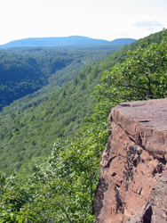
From there, the trail hugs the edge of the escarpment, unveiling one breathtaking view after another. Look down into Kaaterskill Clove, across to Kaaterskill High Peak and Roundtop, and out over the Hudson Valley to the Taconics. Viewpoints like Sunset Rock and Inspiration Point (with century-old carvings etched into stone slabs) offer some of the finest panoramic scenery in the Catskills, and the drop-offs are just as dramatic, so caution is advised.
The return follows a more relaxed grade via the red-blazed Schutt Road Trail, a gentle carriage road descent through mixed woods that gradually loops back to the trailhead. With sweeping vistas, historical markers, and a mix of rugged terrain and mellow trail, this loop is perfect for experienced hikers looking for a classic Catskill day hike rich in both natural beauty and cultural history.
How to Get There
Trails Related to this Hike
Don’t Leave Unprepared
The digital version of this map is available exclusively at:
Detailed Hike Description
Publication: Submitted by Daniel Chazin on 09/25/2008, updated/verified on 09/05/2014
Cross to the east side of the road and follow the blue-blazed Escarpment Trail (co-aligned with a yellow-blazed horse trail) into the woods. The trail heads south and descends through a mixed forest of hemlocks and deciduous trees.
In half a mile, the trail crosses two old railroad rights-of-way and a bridge over the outlet of North/South Lake. After crossing another bridge, you'll reach a four-way junction, where you will find a trail register (please sign). Here, you turn right, continuing to follow the blue blazes of the Escarpment Trail along a woods road, with the stream below to the right. You'll soon cross a wide bridge.
A short distance beyond, the trail turns left, leaving the road, and begins a steady climb. After leveling off, it begins to descend, first gradually, then more steeply. At the base of the descent, a stone monument on the left memorializes Frank Layman, a firefighter who lost his life here in August 1900.
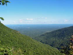
You've now reached the edge of the escarpment, which you'll follow for the next mile and a half. The trail turns left here, and in a short distance, it turns left again and begins to climb. In 500 feet, after a steep climb up a large rock, it reaches a panoramic viewpoint. Kaaterskill Clove - which you traversed to get here - is directly below, Kaaterskill High Peak and Roundtop tower above the clove to the south, and the small community of Twilight Park may be seen to the right.
A little further along, you’ll pass another expansive viewpoint on the right, and then you’ll climb to a third viewpoint with a more limited view. Just beyond, the trail climbs steeply, then more gradually, and it reaches a junction with a yellow-blazed connector trail that begins on the left.
Continue ahead on the blue-blazed trail, which shortly emerges onto Sunset Rock (usually marked by a sign), with a somewhat limited south-facing view. After a short level stretch, the trail descends steeply over rock ledges to reach Inspiration Point (Trail Conference Map 141 labels this viewpoint as "Sunset Rock" and the following viewpoint as "Inspiration Point"). Here, two large flat rocks with carved inscriptions (some of which date back over 100 years) afford panoramic views to the west and south. Be careful when approaching the edge, as the drop is precipitous!
A short distance beyond, you'll reach a broad viewpoint to the east over the Hudson River valley, with the Taconic Mountains beyond. For the next quarter mile, the trail continues to run very close to the edge of the escarpment, with more views.
About three-quarters of a mile beyond Inspiration Point, you'll come to a T-intersection with a yellow-blazed horse trail. Turn right, now following both blue and yellow blazes, and in 300 feet, turn left, continuing to follow the blue- and yellow-blazed trail. In the next half mile, you'll gradually climb about 200 vertical feet.
At the next junction, the blue-blazed Escarpment Trail turns right, but you should bear left, now following the red-blazed Schutt Road Trail and the yellow-blazed horse trail. In 60 feet, turn left, continuing to follow the red and yellow blazes.
In the next mile, you'll descend gradually along an old carriage road, passing the end of the yellow-blazed connector trail on the left. The Schutt Road Trail ends at the four-way junction that you passed towards the start of the hike. Continue ahead, immediately crossing a bridge, and follow the blue-blazed Escarpment Trail back to the parking area where the hike began.
Support the trails you love
Your gift helps build, maintain, and protect over 2,150 miles of trails across the region.

Get your hands dirty for a great cause.
Join our network of volunteers and help maintain the trails we all rely on.

Protect the trails you love.
Your gift helps build, maintain, and protect over 2,150 miles of trails across the region.

Be part of something bigger.
Membership supports our mission year-round and connects you to a passionate trail community.