The Long Path – Section 38
Featherstonhaugh State Forest to the Mohawk River


Distance: 10.2 miles
Parks: Featherstonhaugh State Forest, Plotter Kill Preserve, Empire State Trail, Lock 9 State Canal Park
Maps: LP Interactive Map
This section is begins on a road through scenic farm country. In the beginning there are several vistas of the Rotterdam Hills and the Helderbergs. The trail passes through the Plotter Kill Nature Preserve in the Town of Rotterdam, where a short side trip will lead to some pretty falls. The trail then follows a road under the New York State Thruway and then turns onto the Mohawk-Hudson Bike-Hike Trail (Empire State Trail) along the old Erie Canal to Rotterdam Junction. Section 38 ends in the Canal Park at Lock #9, immediately after crossing the Mohawk River. The blazing on this section is sporadic.
Access
From I-87 N/NYS Thruway, keep straight onto I-90 W/NYS Thruway. In 4.7 mi take exit 25; take ramp on right for I-890 toward Schenectady. At exit 2A, take ramp on right for Route 337 toward Campbell Road, then bear right onto Route 337 (Rice Road). In 0.8 mi bear right onto Putnam Road (County Route 54), and in 1.8 mi turn right onto Route 159 (Mariaville Road). Continue 5.5 mi, then turn left onto Lake Road (County Route 88). In 0.3 mi bear right onto Judith Lane, and in 0.2 mi arrive at the parking area of Featherstonhaugh.
Parking
0.00 Featherstonhaugh Boat Launch Parking lot on Judith Lane. (42.81148°, -74.11646°)
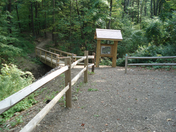
6.40 Plotter Kill Preserve parking lot off Gregg Road. (42.84646°, -74.02944°)
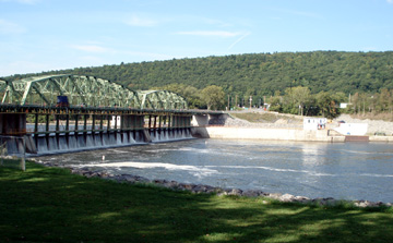
10.20 Lock #9 Canal Park. (42.87962°, -74.04102°)
Camping
Camping in Featherstonhaugh State Forest is allowed, but subject to the standard DEC rules and regulations.
Detailed Trail Description
0.00 Continue straight (east) on Judith Lane.
0.20 Turn left on Lake Road.
0.50 Turn right on Route 159 (Mariaville Road), and continue east.
2.70 Turn left onto Rynex Corners Road and in 100 feet turn right onto Gifford Road and driveway (#132 Rynex Corners Road).
3.00 The blazed LP trail leaves the town maintained road/driveway to the right, by the unmaintained section of the old town road, and descends toward the creek.
3.20 A few feet before reaching the site where the road crossed on a bridge many years ago, the trail heads left through the woods and parallels the creek. Just upstream from the bridge there was once a grist mill on this side of the creek and a saw mill on the other.
3.40 The LP leaves the creek bank and climb a side-hill slope to the left.
3.50 Emerge at a T intersection of a well maintained pathway and turn right.
3.60 Turn right from the pathway and descend to the creek again. The trail passes a small foundation hole which was the site of a “spinney”, a little shack where a spinster lived for many years back in the early 1800s. Follow along the creek, then turning to the left, climb up to the ridge and reconnect to the pathway.
3.70 Turn right and continue on this pathway.
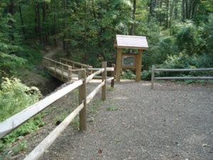
3.80 Cross two foot bridges to reach a stone wall which is the Gifford-Plotter Kill Preserve’s boundary. (The LP blazes end here and we now follow preserve blazing which is maintained by Schenectady County.)
3.90 Continue straight ahead to the intersection with the preserve’s Highland Trail and continue straight on the yellow blazed trail.
4.00 Following a zigzag, the trail turns left to reach the end of the yellow-blazed at the junction with the red blazed North Rim Trail. Continue straight on this red trail, heading NNE.
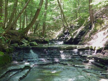
4.10 Pass the large waterfalls on the right. Use extreme caution in this area as many visitors have been injured here.
4.30 Reach another junction with the yellow trail. Continue on the red trail which swings to the left and ascends the rim of Rynex Creek. Start to descend by way of switchbacks to the creek. Follow the creek downstream to a shallow crossing just above the waterfalls. (There is no bridge here and the crossing may be impassible during high water events, use extreme caution here.)
4.40 Cross Rynex Creek and climb steeply on old steps to the ridge top and then start a steady descent.
4.60 Reach a trail junction from the right. Stay straight on the rim trail.
4.80 After a quick left-right jog, the trail crosses under power lines.
5.00 Continue to descend, cross an access road and follow the trail along the rim again.
5.10 Pass by a trail junction from the right which crosses the gorge to the south rim.
5.20 Pass by a yellow blazed trail on the right.
5.30 The trail bears left and crosses two small streams.
5.70 Pass under another power line.
5.90 Reach a trail junction on the left where a #7 sign is nailed to a tree on the right; leave the red trail, turning left onto a trail marked with red disks over white paint.
6.10 The trail swings left and in 200 feet swings back right to cross a foot bridge.
6.40 Reach another foot bridge and the Lower Gregg Road trailhead parking area. Continue north by once again following LP blazes on Lower Gregg Road past the intersection with Crawford Road, under the NYS Thruway and over the railroad tracks to a T intersection.
6.90 Turn left and continue west for a short distance on NYS Route 5S.
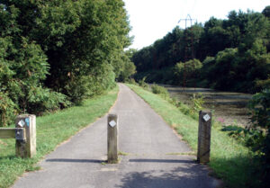
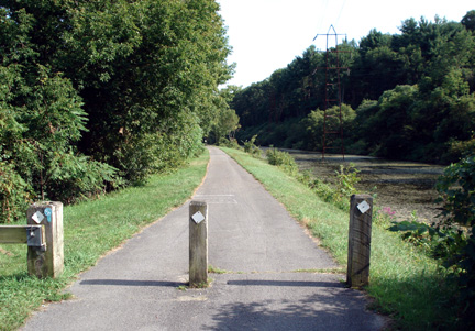
7.10 The trail turns left to join the Mohawk-Hudson Bike-Hike Trail, which runs just south of the Mohawk River along sections of the old Erie Canal and is also part of the Empire State Trail.
9.25 Proceed on the Mohawk-Hudson Bike-Hike Trail through a tunnel under the railroad tracks.
9.50 Turn right onto Iroquois Street, use the crosswalk to cross Main Street/NYS Route 5S, and turn left. Turn right onto the next street, Spruce Street, left onto Leonard Street, and finally reach Bridge Street/NYS Route 103.
9.80 Turn right onto Bridge Street/NYS Route 103 and approach the Barge Canal Lock #9 Bridge over the Mohawk River. Before reaching the bridge, cross to the west side of the road to follow the pedestrian sidewalk across the bridge.
10.20 Reach the end of this section after crossing the bridge and reaching the junction of NYS Route 5 and NYS Route 103. Just after crossing the bridge, you’ll pass the driveway on the opposite side of the road that leads to the Lock 9 State Canal Park.