Gertrude’s Nose Loop/Millbrook Mountain
Park: Minnewaska State Park Preserve
Ulster Co., NY
GPS: 41.729, -74.2371
Distance: 7 Miles
Difficulty: Mod./Strenuous
This loop hike runs along the dramatic cliffs of Shawangunk conglomerate, with exceptionally fine views.
Hike Description
Gertrude’s Nose Loop/Millbrook Mountain
This hike traverses the ridge of Gertrude’s Nose – one of the most spectacular rock formations in the Shawangunks.
From the end of the parking area, bear left on a dirt road, then turn right on the red-blazed Lake Minnewaska Carriage Road that encircles Lake Minnewaska. After a short descent, you’ll reach a junction with the Upper Awosting Carriage Road (with a swimming area on the left). Continue ahead on the Lake Minnewaska Carriage Road, which now begins to climb. Soon, you’ll reach a junction with the blue-blazed Castle Point Carriage Road, which begins on the right. Again, continue ahead on the red-blazed Lake Minnewaska Carriage Road.
About 0.8 miles from the start, you’ll reach a junction with the yellow-blazed Millbrook Mountain Carriage Road. Turn right, following the yellow blazes. Soon, you’ll come to another junction. The Hamilton Point Carriage Road continues straight ahead, but you should bear left, continuing to follow the Millbrook Mountain Carriage Road.

In about half a mile, you’ll reach a glacial erratic to the right of the trail known as Patterson’s Pellet. Here, there are views to the west over the Palmaghatt Ravine – a pristine wilderness valley that separates the Millbrook Mountain-Gertrude’s Nose ridge that you are following from the main ridge to the west. Continue ahead along the carriage road, passing more views of this beautiful, unspoiled ravine.
Soon, you’ll notice a sign on the right marking the start of the red-blazed Gertrude’s Nose Trail. Turn right and follow this trail, which climbs through a dense evergreen forest to reach another west-facing viewpoint over the Palmaghatt Ravine. The trail now descends, first moderately, then more steeply, and crosses a stream under a power line.
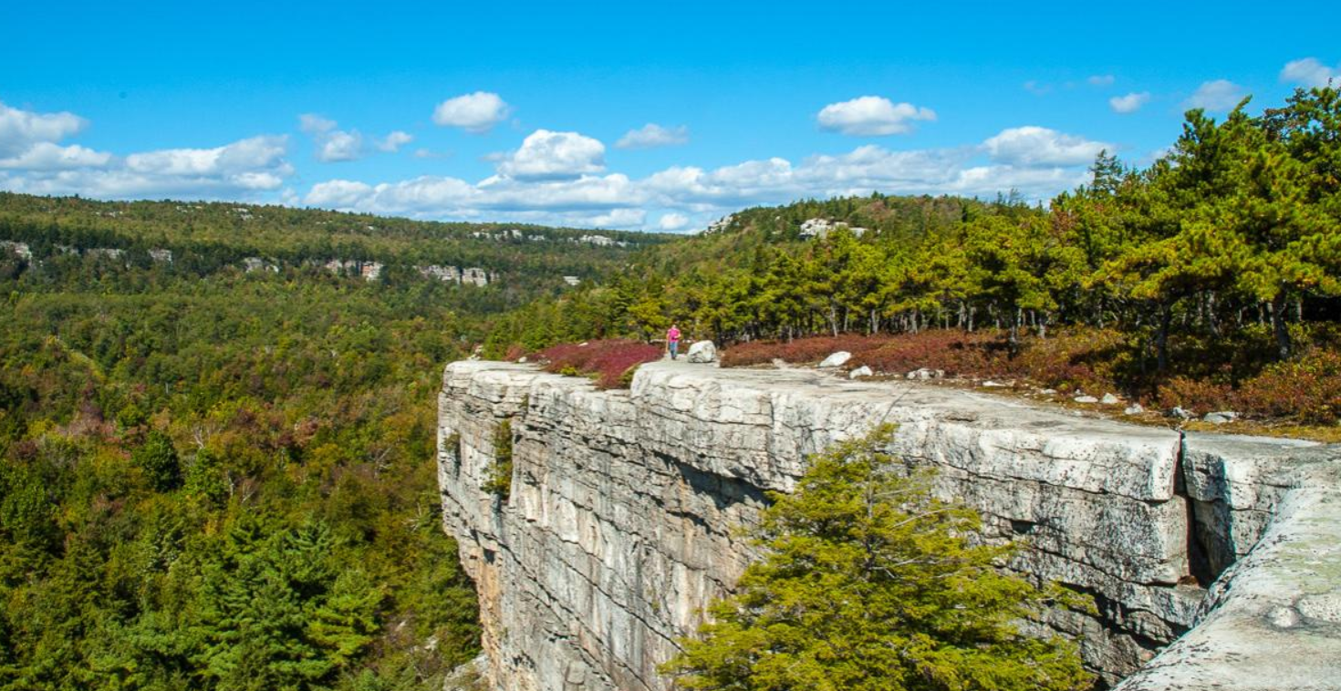
The trail now climbs along bare rock ledges, with sheer drops of several hundred feet just to the right of the trail. This trail section is one of the most scenic in the entire Shawangunks, with many views over the Palmaghatt Ravine to the west. Glacial erratics perched near the cliff edges, deep crevices in the rock, and the pitch pines growing out these crevices make the hike even more interesting. The trail is sometimes a little difficult to follow (most of the blazes are painted on the rocks), and it detours away from the edge and heads through the woods in a few places. You’ll want to take some time to savor the beauty of this magnificent area. Keep in mind, though, that the unprotected cliff edge can be dangerous (children should be kept well away from the edge). This hike is not recommended for those who are fearful of heights!
You’ll eventually come out at Gertrude’s Nose, the southern tip of the ridge, which features broad views to the east and south. Here, the trail curves around and begins to run north along the eastern side of the ridge. This part of the ridge is not as dramatic as the western section that you just traversed, as it lacks the many open rock slabs. But there are a number of good viewpoints over the Wallkill Valley to the east from rocks to the right of the trail.

After a relatively flat section, the trail descends to once again cross beneath the power line. A short distance ahead, you’ll notice an unmarked trail on the right. Follow this trail a short distance to a deep crevice in the rock. You can feel the cool air escaping from this crevice – quite refreshing on a hot day!
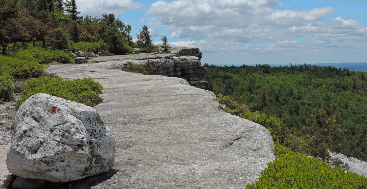
Return to the main trail and turn right. The Gertrude’s Nose Trail now begins a steep climb. At the top, you can look back to the southeast at the ridge you just traversed. After a relatively level stretch, you’ll emerge onto an area where pitch pines grow out of long expanses of bedrock. There are several panoramic east-facing viewpoints along this trail section.
About three-quarters of a mile from the second power line crossing, you’ll notice that the Millbrook Mountain Carriage Road begins to parallel the trail just to the left. Soon, you’ll reach the turnaround at the end of the carriage road, just below the summit of Millbrook Mountain. To the right, at the top of the rock ledges, there are outstanding views to the north and east, with the Sky Top Tower visible on the ridge to the north.
The Gertrude’s Nose Trail ends here, but you should briefly continue ahead on the Millbrook Ridge Trail. You now enter lands of the Mohonk Preserve, but it is not necessary to obtain a day-use permit from the Preserve to continue the hike. Just ahead, watch carefully for a sign pointing to “Lake Minnewaska.” Turn left here and head downhill on the Millbrook Mountain Trail, also blazed red.
Follow the Millbrook Mountain Trail as it descends steadily into the valley of the Coxing Kill. In about a quarter of a mile, the blue-blazed Coxing Kill Trail leaves to the right, but you should continue ahead on the red-blazed Millbrook Mountain Trail. Beyond this point, the trail is often very wet, and you should exercise caution to avoid slipping on the wet rocks.
At the base of the descent, you’ll cross the scenic Coxing Kill. The trail now begins a steady climb up to Lake Minnewaska. This section of the trail is generally drier than the section south of the Coxing Kill, but you should still be alert for slippery spots. As you near Lake Minnewaska, you’ll pass a broad viewpoint to the north, with the Sky Top Tower dominating the horizon.

After crossing the lake’s outlet stream, you’ll reach the end of the Millbrook Mountain Trail. Turn right onto the Lake Minnewaska Carriage Road and follow it in a counterclockwise direction along the northeast shore of the lake. Soon, a side trail leaves to the left, but you should continue ahead on the main carriage road. At the next fork in the road, take the left fork, which leads up to the former site of the Cliff House, now a picnic area, that overlooks the lake.
From the Cliff House site, continue downhill along the carriage road. Just beyond a junction where a road to the right leads to an old barn, continue straight ahead on a footpath as the carriage road curves to the left. This path leads over a picturesque wooden bridge (known as the “Dry Bridge”) and continues ahead to join the main carriage road, which leads back to the parking area where the hike began.
Publication: Submitted by Daniel Chazinon 08/07/2003updated/verified on 09/04/2017