Black Mountain Loop from Anthony Wayne Recreation Area
Park: Harriman-Bear Mountain State Parks
Orange Co., NY
GPS: 41.288905, -74.02333
Distance: 8 Miles
Difficulty: Mod./strenuous
This loop hike climbs to the ridge of Black Mountain, with views over the Hudson River and the surrounding hills, and returns via lesser-used trails.
Hike Description
Black Mountain Loop
The first part of the hike includes climbs totaling over 800 vertical feet over the Black and Letterrock Mountains, but the remainder of the hike follows relatively level, little-used trails.
From the kiosk at the southeast corner of the parking area, proceed south on the Horn Hill Loop Mountain Bike Trail, with blue-on-white diamond blazes. This pleasant, level trail (little used by bicycles) passes through a pine forest and crosses several bridges. In about half a mile, you’ll reach an intersection with the white-blazed Appalachian Trail (A.T.), marked by a sign. Turn right, leaving the Bike Trail, and follow the white A.T. blazes, soon crossing a footbridge over Beechy Bottom Brook.
After climbing an embankment, you’ll come to a junction with the red-dot-on-white-blazed Ramapo-Dunderberg (R-D) Trail. Turn right and follow the joint A.T./R-D, with both red-dot-on-white and white blazes. A short distance ahead, the trail descends wooden steps and crosses the Palisades Interstate Parkway – first the northbound lanes, then a wooded median strip, and finally the southbound lanes. The cars are traveling at high speeds, so use extreme caution!
The A.T./R-D now begins to climb Black Mountain, passing through an area with dense barberry thickets and crossing several old stone walls (signs that the land in this area was once farmed). At the top of a steep section of the climb, a cairn marks the intersection with the 1779 Trail (blue-on-white blazes). Continue ahead on the A.T./R-D, which descends briefly to cross a stream on rocks and then resumes a steady climb. For part of the way, the trail follows an improved route constructed by the Long Distance Trails Crew of the New York-New Jersey Trail Conference.
After a very steep climb over a rock outcrop, the trail emerges onto a viewpoint to the south and southeast. The AT&T relay towers just south of Route 106 may be seen directly ahead, with the Hudson River visible to the left. You’ll want to take a short break here to rest from the climb. As you continue ahead along the summit ridge, there are views through the trees to the right (northeast) over Bear Mountain.
When you reach the highest point on the ridge, turn right and walk north for about 100 feet. Here you will see an open pit – a remnant of the Spanish Mine. Piles of tailings (waste rock that contains little or no iron ore) are visible adjacent to the pit. The history of this mine is the subject of much conjecture – one possible account is outlined in Ed Lenik’s book Iron Mine Trails.
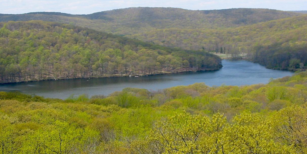
Continue ahead on the A.T./R-D, which descends steeply through a crevice in the rock and levels off along the south side of the ridge. After another rather steep descent over rocks and stone steps, you’ll reach a panoramic viewpoint over Silvermine Lake from a rock ledge. The trail continues to descend until it crosses a small stream at the lowest point between the Black and Letterrock Mountains.
Across the stream, you’ll notice a well-built stone embankment that carries the Silvermine Ski Road, built by workers of the Temporary Emergency Relief Administration in 1934. After crossing this moss-covered road, the A.T./R-D begins a gradual climb of Letterrock Mountain. From a high point on the ridge, it descends through dense mountain laurel thickets, then traverses a few short ups and downs. After descending stone steps, the trail reaches the stone William Brien Memorial Shelter (built in 1933 as the Letterrock Shelter and renamed in 1957 in memory of Mr. Brien).
With the shelter on your right, turn left, leaving the A.T./R-D, and begin to follow the yellow-blazed Menomine Trail, which descends gently into a valley. After a while, the trail joins an old woods road, with a stream in a ravine below to the left. Since the road is badly eroded, portions of the trail have been rerouted to parallel the road.
The yellow trail ends at an intersection with the Red Cross Trail (red cross on white). Turn left onto the Red Cross Trail, crossing the stream on a wooden footbridge and continuing along another woods road. About 250 feet beyond the bridge, you’ll notice a large barberry-covered depression to the left of the trail. This is the site of the “Burnt House” – reputed to have once been the home of woodcutter Jonas Lewis.
After passing a reed-filled marsh to the right, the trail bears left to parallel Stillwater Brook. In a short distance, it turns sharply right, crosses the wide brook on rocks (this crossing can be difficult if the water is high), proceeds through a wet area, and begins a gentle climb along the shoulder of Big Bog Mountain. You will soon hear the sounds of automobile traffic – a sign that you are once again approaching the Palisades Interstate Parkway.
When you reach the southbound lanes of Parkway, turn left and follow the road for 150 feet, then cross opposite the end of the guardrail and enter the woods on the median strip. At the northbound lanes, cross the road, turn left and follow the guardrail for 100 feet, then turn right at a Red Cross blaze on a tree and reenter the woods. Again, be sure to use extreme care when crossing this busy road!
In about 0.2 miles, you’ll reach a T-intersection with a woods road – the route of the 1779 Trail. A double-blaze indicates that the Red Cross Trail turns right here, but you should turn left, leaving the Red Cross Trail, and begin to follow the blue-on-white-blazed 1779 Trail.
The 1779 Trail briefly approaches the Parkway, but it soon bears right, away from the busy road. After crossing a stone-lined causeway over a brook, the 1779 Trail turns left onto another woods road, the route of the Bike Trail. For a short distance, you follow both the 1779 Trail and the Bike Trail, but when the 1779 Trail leaves to the left, you should continue ahead on the Bike Trail. The Bike Trail once again comes near the Parkway, but it runs high above the road, which is in a rock cut.
In another third of a mile, you’ll notice a cairn on the right side of the road. Here, the Bike Trail splits into two branches, and you should turn left, leaving the wide woods road and following a slightly rougher road (still the route of the Bike Trail), which descends to parallel a brook. After bearing right, away from the brook, the R-D Trail joins from the left.
When the R-D Trail turns right, continue ahead on the Bike Trail. A short distance ahead, you’ll come to the intersection with the A.T. (marked by a sign) that you encountered earlier in the hike. Continue to follow the Bike Trail, now retracing your steps, until you reach the parking area where the hike began.
Publication: Submitted by Daniel Chazinon 05/09/2008updated/verified on 01/30/2017