Hike: Cranberry Lake Preserve Loop
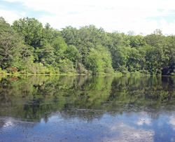
Cranberry Lake Preserve – Photo: Jane Daniels
The Cranberry Lake Preserve loop is a peaceful 3.5-mile loop that explores the varied terrain of Cranberry Lake Preserve, a 190-acre natural area tucked amid the suburban bustle of Westchester County. Despite its modest size, the preserve offers a rich and diverse hiking experience, from tranquil lakeside paths and stone-lined wetlands to historic remnants of past industry. Beginning at the Nature Center, the route travels through forested trails marked by numbered junctions and a well-blazed network of color-coded loops.
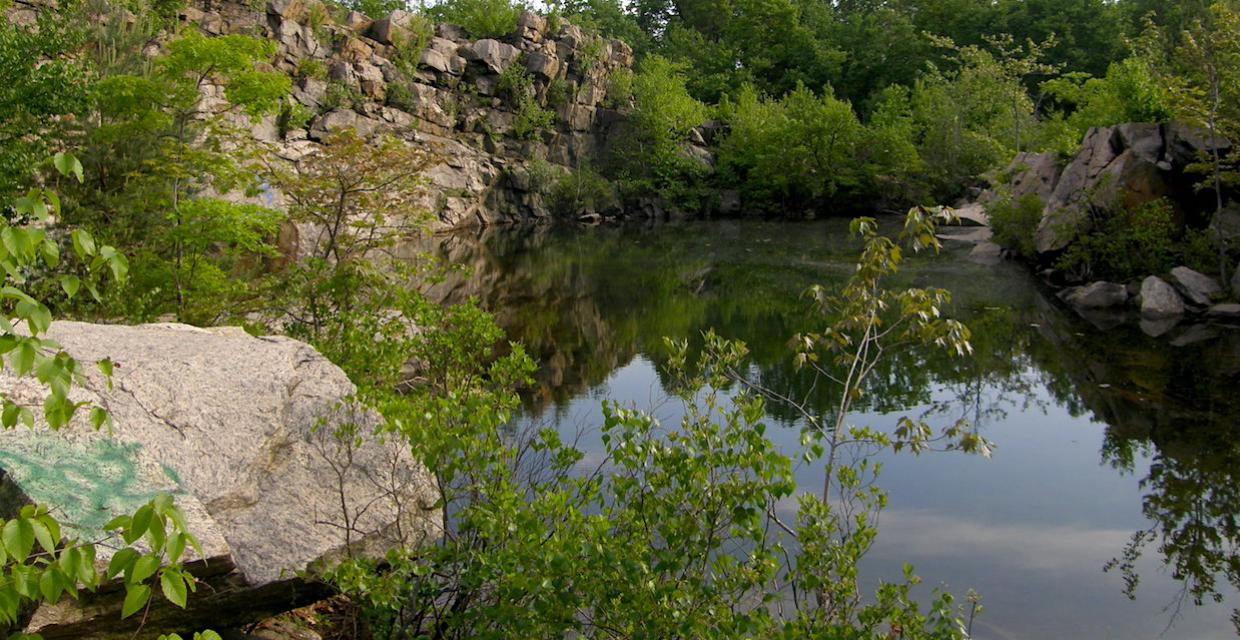
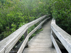
The hike winds past Cranberry Lake itself, with shoreline views and quiet ledges overlooking the water. Along the way, hikers will pass over boardwalks and footbridges, through mountain laurel stands, and by landmarks such as the Bent Bridge, an old stone chamber, and the expertly crafted dry stone boundary wall that separates the preserve from New York City watershed lands. Midway through, the trail skirts the remains of a century-old quarry facility once used in the construction of the Kensico Reservoir, offering a glimpse into the region’s industrial past.
This is a relatively gentle hike, ideal for families or casual hikers, though it includes occasional rocky footing and short but steep grades. With its mix of natural beauty, local history, and surprising quiet, Cranberry Lake Preserve is a hidden gem worth exploring year-round.
How to Get There
Free Maps from The Trail Conference
Don’t Leave Unprepared
The digital version of this map is available exclusively at:
Detailed Hike Description
Publication: Submitted by Daniel Chazin on 02/25/2005 updated/verified on 06/29/2018
Although comprising only 190 acres, Cranberry Lake Preserve is surrounded on several sides by watershed lands. It is a quiet oasis amid suburban Westchester County and offers a pleasant walk around a tranquil lake. Trail junctions in the preserve are marked by numbered wooden signs, and the numbers are referenced in this description.
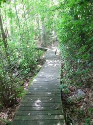
From the Nature Center, proceed south on a wide yellow-blazed path. At a blue sign to the "Lake" (junction #4), turn left and follow an orange-blazed trail downhill to the shore of Cranberry Lake, then turn right (at junction #26) onto a trail with blue and yellow blazes. After briefly following the lake shore, the trail climbs to ledges overlooking the lake, continuing to parallel it. At the end of the lake, it descends. After crossing a boardwalk, the trail reaches junction #6.
Turn left onto a wide path, and following blue, purple, and red blazes, then turn left at the next junction (#7) onto an orange-blazed trail, immediately crossing the Bent Bridge over a bog. The trail runs along old stone walls and passes the "stone chamber" – probably an old root cellar. At the end of the orange trail (junction #16), turn right onto a wide path (an old railroad bed) and follow it to a Y-intersection, with a sign for the New York City Watershed grown into a tree (junction #18).
Bear left here, now following the Red Loop Trail. This trail, which circles the park, will be your route for most of the remainder of the hike. On the right, marking the boundary between the park and New York City Watershed lands, is an expertly laid dry stone wall, built over a century ago and still in nearly perfect condition today (except where damaged by fallen trees). Soon, the trail bears left and heads south, continuing to follow the wall.
At the southern end of the park, with private homes visible ahead through the trees, the red trail turns left and begins to head east. Be alert for a sharp right turn (marked by an arrow on a tree to the left) and head downhill toward Hush Pond, continuing to follow the red trail. Cross the outlet of the pond on puncheons, bear left (north), and soon begin to parallel a wetland on the left. In a short distance, you’ll join a level dirt road, with cliffs on the right.
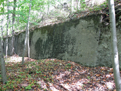
Soon, the cliffs are supplanted by a concrete wall. This wall is a remnant of a facility built about 1912 to crush stone that was quarried just to the east of the trail and used for the construction of the Kensico Reservoir. Just beyond a crumbling section of the wall, you’ll reach junction #13, where a blue-blazed trail leads left to a wooden observation platform. Unfortunately, the view over South Pond is largely obscured by vegetation.
Return to the main trail and turn left (north), now following both blue and red blazes. Soon, you’ll reach a small cascade with a bench (junction #14). Just beyond the bench, turn right, leaving the wide road, and cross the stream on a wooden footbridge, continuing to follow blue and red blazes. At the next fork, bear right and proceed along the Red Loop Trail through a mountain laurel thicket. After a short climb, you’ll reach junction #20, where the Purple (History) Loop, marked with purple-on-white blazes, joins from the right.
The trail now descends rather steeply. At the base of the descent (junction #21), the blue trail joins from the left, and the trails cross a boardwalk. Just beyond, at junction #22, the trails again split. Bear right, continuing to follow the red and purple-on-white trails, which cross another boardwalk. Bear right at junction #23, continuing to follow the red and purple-on-white blazes.
After curving to the left, the trail reaches a T-intersection (junction #34), with cliffs ahead. Here, the red and purple-on white trails turn right, but you should turn left, now following yellow blazes. At the next junction (#33), bear left, continuing to follow the yellow blazes, and descend to the lake. At junction #24, turn right and follow yellow and blue blazes, with the trail paralleling Cranberry Lake. After passing junction #27, you'll reach a viewpoint over the lake (with the view partially obstructed by vegetation). Just beyond, you’ll reach junction #26. Turn right onto the orange trail, follow it back up to the yellow trail at junction #4, and turn right on the yellow trail to return to the Nature Center where the hike began.
Support the trails you love
Your gift helps build, maintain, and protect over 2,150 miles of trails across the region.
Join

Become a member and protect wild places
Shop

Maps, gear & books, all proceeds support trails
Volunteer

Give back by helping maintain the trails
Donate

Keep trails open and safe with a one-time gift