Hike: Short and Scenic Loop Hike on Bullwheel, High Peters Kill, and Red Trails
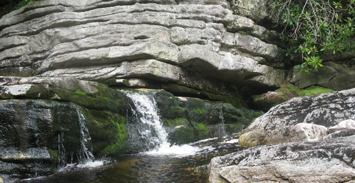
Cascade on the Peters Kill – Photo by Daniel Chazin
This scenic 2.1-mile loop in Minnewaska State Park Preserve offers a compact but memorable tour of the Shawangunks, combining forested carriage roads, dramatic cliffs, cascading streams, and historical relics from a bygone ski era. Starting on the Red Loop Trail, the route quickly joins the Bullwheel Trail, a gradually climbing former carriage road that leads past remnants of the old Ski Minne downhill ski lift, including the original bullwheel slab.
The trail descends through mountain laurel and blueberry thickets, then meets the blue-blazed High Peters Kill Trail, cutting through the Dickie Barre notch with tilted conglomerate cliffs before opening onto a rock ledge viewpoint with distant views of the Catskills. After a steeper descent, the hike turns onto the yellow-blazed trail, which follows the Peters Kill through shaded hemlocks, rhododendron, and slanted rock cascades.
A short link to the Red Trail continues the streamside experience, passing multiple cascades and flumes before the trail climbs gently through open fields to complete the loop.
How to Get There
Trails Related to this Hike
Don’t Leave Unprepared
The digital version of this map is available exclusively at:
Detailed Hike Description
Publication: Submitted by Daniel Chazin on 07/22/2010, updated/verified on 06/22/2018
Although this hike is relatively short, it offers some of the most attractive scenery in the “Gunks.” The average hiker should be able to complete the hike in an hour and a half, but you might want to allow extra time to pause and take in the beautiful scenery.
From a kiosk at the western end of the lower parking area, head north on a gravel road, following the Red Loop Trail. At the top of a rise, a sign and a triple-white blaze on a tree on the right mark the start of the Bullwheel Trail. Turn right onto this trail, which climbs gradually on an old carriage road. After a short descent, the trail bears right at a fork and continues to climb on a rougher route.
After narrowing to a footpath, the trail reaches the crest of the rise, where it passes a concrete slab with steel bolts protruding. A tower that was anchored to the slab via the bolts once supported a pulley for a ski lift – part of the Ski Minne downhill ski area, which operated from 1964 to 1978. The pulley is commonly referred to as a “bullwheel” – hence the name for the trail.
The trail now descends gradually, passing through mountain laurel thickets and blueberry bushes. Several side trails for rock climbers leave to the left. After passing the cliffs of Dickie Barre on the left, the Bullwheel Trail ends at a junction with the blue-blazed High Peters Kill Trail. Turn left onto this trail, which climbs briefly to cut through a notch in Dickie Barre (notice the tilted blocks of conglomerate rock on the left), then begins a long, gradual descent through mountain laurel thickets and blueberry bushes to the Peters Kill.
About halfway down, the trail emerges on exposed rock ledges, with pitch pines growing from the bedrock, and bears right. Before continuing ahead, you should bear left and cross the ledges to reach a dramatic viewpoint from the edge of the cliffs, with the Catskills visible in the distance to the right. Then return to the trail, which descends more steeply for a short distance. The grade soon moderates, and the trail runs close to the edge of the escarpment, with sheer drops on the left.
At the base of the descent, just before reaching the Peters Kill, turn left onto a yellow-blazed trail (at a sign “Peters Kill parking lot”). The trail parallels the picturesque stream amid hemlocks, rhododendron, and mountain laurel. After passing an interesting cascade, where the stream flows over slanted rock slabs, the Yellow Trail bears left, away from the stream, and it soon ends at a sign for the Red Trail. You’ll notice nearby another concrete slab with protruding bolts and steel cables along the ground - more remnants of the downhill Ski Minne operation.
Turn left onto the Red Trail, but in only 20 feet, turn right and follow the red blazes parallel to the stream. This trail section is even more scenic than the previous one, as you pass numerous cascades and flumes in the stream.
After reaching a small waterfall and a pool on the right (a good place to stop and take a break), the Red Trail bears left, leaving the stream, and climbs back towards Route 44/55. At the top of the climb, the trail turns left and follows a gravel path through successional fields, soon returning to the parking area where the hike began.
Support the trails you love
Your gift helps build, maintain, and protect over 2,150 miles of trails across the region.
Join

Become a member and protect wild places
Shop

Maps, gear & books, all proceeds support trails
Volunteer

Give back by helping maintain the trails
Donate

Keep trails open and safe with a one-time gift