Hike: Stillman/Highlands/Bluebird Trails Loop from Mountain Road
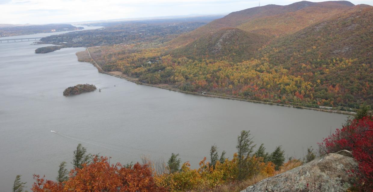
North-facing view over the Hudson River from Storm King Mountain – Photo by Daniel Chazin
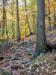
This 4.5-mile loop explores the dramatic ridgelines and sweeping vistas of Storm King Mountain, a crown jewel of the Hudson Highlands. Starting from the trailhead off Route 218, the hike climbs steadily along the yellow-blazed Stillman Trail, soon joined by the teal-diamond Highlands Trail. Together, they lead hikers through a series of ascents, ridgeline scrambles, and unforgettable viewpoints high above the Hudson River.
A side trip along the red/blue-blazed Bluebird Trail offers quieter forest paths and a bit of steep, switchback climbing before rejoining the main route. From there, the hike ascends to Storm King’s summit and an open ledge offering some of the most iconic vistas in the region. Look east across the Hudson to Breakneck Ridge, Bannerman’s Castle on Pollepel Island, and the distant Shawangunks and Catskills. The views continue south toward Cold Spring and Constitution Island, and north to Schunemunk and Beacon Mountains.
Though relatively short, this hike is rugged and rocky in spots, with steep climbs, narrow sidehill sections, and exposed ledges that require sure footing, especially when wet or icy. But for seasoned hikers, the payoff is immense: a loop packed with scenic drama, Hudson River history, and a true sense of mountain adventure.
How to Get There
Trails Related to this Hike
Don’t Leave Unprepared
The digital version of this map is available exclusively at:
Detailed Hike Description
Publication: Submitted by Daniel Chazin on 10/23/2008, updated/verified on 09/08/2024
From the parking area, proceed uphill on a wide gravel road, following the yellow blazes of the Stillman Trail. In about half a mile, after crossing a stone-arch bridge, the trail turns left, leaving the gravel road. Just before reaching a north-facing viewpoint over the Hudson River, the teal-diamond-blazed Highlands Trail joins from the left.
The joint Stillman/Highlands Trail now begins to climb on a footpath. With the gravel road just to the right, the trail turns sharply left and continues to climb. At the next sharp left turn, a triple red/blue blaze on a tree to the left marks the start of the red/blue-blazed Bluebird Trail. (A small stone spring house may be seen just below this intersection.) Turn right onto the Bluebird Trail, which follows around the side of a hill, then climbs gently. After turning left onto a woods road, the trail climbs rather steeply on switchbacks. It passes a limited west-facing viewpoint and ends at a junction with the Stillman/Highlands Trail (yellow and teal diamond blazes).
Turn left, uphill, and continue on the Stillman/Highlands Trail. A short distance ahead, you’ll reach the northern end of the blue-blazed Howell Trail, which leaves to the right. Bear left here, continuing along the yellow/teal diamond-blazed trail, which follows a relatively level route. After a short, steep climb, you’ll reach a limited view to the northwest. The Metro-North Railroad’s Moodna Viaduct is directly ahead, with Schunemunk Mountain to its left. A few minutes ahead, after climbing a little more, you’ll come to a viewpoint looking north over the Hudson River. North and South Beacon Mountain are to the right, and the Newburgh-Beacon Bridge is visible in the distance.
Proceed ahead, and climb to the summit of Storm King Mountain. Just beyond, you’ll come to a broad but somewhat obstructed north-facing viewpoint, with a good view of the Newburgh-Beacon Bridge spanning the Hudson River. Continue ahead for a short distance, and you'll come to a panoramic, unobstructed viewpoint over the Hudson River, with superb views. Pollepel Island, with the ruins of Bannerman’s Castle, is directly below. To the east, Breakneck Ridge (marked by the rail tunnel) is visible across the river. The stone building at the foot of Breakneck Ridge caps a shaft of the Catskill Aqueduct, which tunnels over 1,100 feet below the river (views of both the rail tunnel under Breakneck Ridge and the stone building at its foot may be obstructed by vegetation) . North Beacon Mountain (with communications towers) and South Beacon Mountain (with a fire tower) are to the northeast, and the Newburgh-Beacon Bridge crosses the river in the distance. The Shawangunks and Catskills can be seen on a clear day. To the left, the village of Cornwall is below, along the west bank of the river. The rail line running along the east shore of the Hudson is Metro-North’s Hudson Line (also the route of Amtrak trains to Albany).
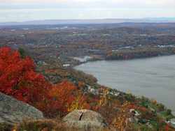
The Stillman/Highlands Trail now continues to descend, soon reaching a junction with the white-blazed By-Pass Trail. Continue along the yellow/teal diamond-blazed Stillman/Highlands Trail, which turns sharply left, immediately reaching a panoramic viewpoint from rock ledges on the right. This viewpoint faces south, with the village of Cold Spring visible across the river to the southeast, and Constitution Island jutting into the river just beyond. Even better views can be had from rock ledges a little further along the trail.
Soon, the Stillman/Highlands Trail bears left and descends along a beautiful stretch of sidehill trail. This narrow trail is quite rocky and can be slippery when wet or covered with snow or ice, so use caution. After passing another panoramic viewpoint to the north, the trail descends on a switchback. About a third of a mile further on, the trail goes down another switchback and crosses a wooden bridge over a steep drop at the edge of a cliff.
Shortly thereafter, you’ll reach the junction with the Bluebird Trail that you encountered earlier in the hike. Turn right and continue to follow the yellow-blazed Stillman Trail, retracing your steps back to the parking area where the hike began.
Support the trails you love
Your gift helps build, maintain, and protect over 2,150 miles of trails across the region.

Get your hands dirty for a great cause.
Join our network of volunteers and help maintain the trails we all rely on.

Protect the trails you love.
Your gift helps build, maintain, and protect over 2,150 miles of trails across the region.

Be part of something bigger.
Membership supports our mission year-round and connects you to a passionate trail community.